As the Earth takes approximately twenty-four hours to complete the cycle of rotational movement - which results in existence alternating between days and nights - the planet is divided into 24 time zones, where each time zone represents one hour in its area of coverage. This count is made from the Greenwich Meridian, an imaginary line established by convention and which “cuts” the city of London and its entire length towards the south.
In this way, all locations that are to the east (east) in relation to Greenwich have their hours summed by the number of time zones, while everything to the west (west) has its hours diminished.
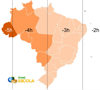
The Brazilian territory, being in the western hemisphere, has its time delayed in relation to the mentioned meridian. In addition, because the country has a large extension, its location is divided into four time zones, whose official demarcation (the legal time) is established according to the following map:

Map with Brazilian time zones. The lines represent the real time, and the colors indicate the legal time.
The vertical lines drawn above represent the “real” time of the zones, that is, the exact time in relation to the distance of each one of the time zones. However, if this division were adopted to the letter, it would be very complicated for certain locations that would be positioned in two different zones at the same time. Therefore, it is established in Brazil - and also in the world - the cool time, which is officially adopted by governments, represented by the color differences on the map above.
O first time zone Brazilian is two hours behind the Greenwich Meridian and one hour ahead of Brasília time. This time zone only covers some oceanic islands belonging to Brazil, such as Fernando de Noronha and Penedos de São Pedro and São Paulo.
O second time zone of the country is three hours behind Greenwich and covers most of the national territory, with the all of the Northeast, Southeast and South regions, in addition to the states of Pará, Amapá, Tocantins, Goiás and the District Federal. It is the official time for Brasília.
O third time zone it is four hours behind Greenwich and one hour behind Brasília time. In summer time, this difference increases to two hours, compared to Brasília time, in the states of Roraima, Rondônia and Amazonas (which do not adopt this special schedule) and remains the same in Mato Grosso and Mato Grosso do Sul (states that adopt the schedule of summer).
O fourth time zone it is five hours behind Greenwich and two hours behind Brasília time, increasing to three hours during daylight saving time. It only covers the state of Acre and a small western part of Amazonas. This time zone was extinguished in 2008, when the area became part of the zone of -4, however, in September 2013, this extinction was revoked after approval in a referendum enacted in 2010.
Are you confused about the various official changes in Brazilian time zones? Click here and understand the changes
By Rodolfo Alves Pena
Graduated in Geography
Source: Brazil School - https://brasilescola.uol.com.br/brasil/fuso-horario-brasileiro.htm
