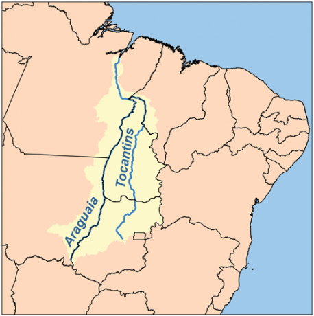
THE Tocantins-Araguaia Basin gets its name because it is formed mainly by the Tocantins river, with 2,416 km and the Araguaia river, with 2,115 km. As it is located only in Brazil, it is considered the largest hydrographic basin entirely in Brazil.
The Tocantins-Araguaia Basin is located northeast of the state of Goiás, and connects to 49 municipalities in different parts of the country. Find out which regions the basin can be located:
- In the North region, it is found in the states of Pará and Tocantins;
- In the region Midwest, is located in the states of Goiás, Mato Grosso and Distrito Federal;
- In the Northeast region, the Tocantins-Araguaia basin is in Maranhão.
Index
- Importance of the Tocantins-Araguaia Basin
- Tocantins-Araguaia Basin Hydroelectric Power Plants
- Main rivers of the Tocantins-Araguaia Basin
Importance of the Tocantins-Araguaia Basin

Most of the rivers in the Tocantins-Araguaia Basin are navigable, having great importance for the region's economy, especially for the transport of agricultural products.
In addition, the energy generated at the Tucuruí Plant, in addition to supplying most cities in the region north-central Brazil is used by mining companies, mainly located in the Serra dos Carajás (Pará).
besides the ttransport of agricultural and energy products generated by this basin, fishing is also an economic activity developed in the rivers of this hydrographic basin.
- Free Online Inclusive Education Course
- Free Online Toy Library and Learning Course
- Free Online Math Games Course in Early Childhood Education
- Free Online Pedagogical Cultural Workshops Course
Tocantins-Araguaia Basin Hydroelectric Power Plants
With an area of approximately 960 thousand km², the Tocantins-Araguaia basin drains about 11% of the territory national, being the second hydrographic basin in energy production in the country, with the presence of hydroelectric power plants.
The plants that stand out are: Tucuruí Plant, on the Tocantins River, in the state of Pará, and the Lajeado Plant, in Tocantins.
Main rivers of the Tocantins-Araguaia Basin
Formed by several rivers, the the main ones that form the Tocantins-Araguaia Basin are:
- Tocantins River
- Araguaia River
- river of souls
- Formoso river
- egrets river
- Baggage River
- Rio Tocantinzinho
- Parana River
- River Manuel Alves Grande
- river sleep
- Santa Teresa River
- Rio Cane Brava
- Santa Clara River
- river of ducks
- Uru River
- Cocoa River
- clear river
- crystalline river
- Kayapó River
- Crixá-açu River
The region of this hydrographic basin has been suffering environmental problems generated by mineral exploration and increased agricultural activities.
While the first economic activity is responsible for the increase in river pollution, the second has caused an increase in deforestation aimed at expanding agricultural areas.
Also read: Paraguay River Basin – Extent, location, map, economy, Pantanal
The password was sent to her email.

