O La Niña it consists of a cyclical change in the mean temperatures of the Pacific Ocean, being observed mainly in waters located in the central and eastern portion of this ocean. Such transformation is capable of modifying a series of other phenomena, such as heat distribution, rainfall concentration, drought formation and fishing. When the change in the temperature of the waters of the Pacific Ocean points to a reduction in thermal averages, the phenomenon is named La Niña. In short: the La Niña effect is linked to the cooling of the average temperatures of the waters of the Pacific Ocean, representing the exact opposite of the El Niño phenomenon, which produces an abnormal heating of their temperatures.
Like El Niño, the origins of La Niña are still quite controversial in the scientific world, but its alternation with El Niño points out for changes in solar heat intensity, that is, solar cycles that now determine greater solar radiation and consequent heating of water of the Pacific, now determine a weakening of the solar radiation that reaches the planet, promoting the cooling of the temperature of the waters of the Pacific. In the case of an ocean that covers practically 1/3 of the Earth's surface, the implications of these alternations are very wide and affect the distribution of heat and humidity in different parts of the globe.
The La Niña phenomenon occurs in the intervals between El Niño and the situation of normal temperatures in the Pacific Ocean. Its occurrence is due to the strengthening of subtropical high pressure zones, located approximately at a latitude of 30º. For this reason, the trade winds, which are born exactly in this location, gain greater intensity, remembering that the winds are originated by the formation of high pressure zones. The cooler air, and at the same time denser, potentiates the force of atmospheric pressure and, consequently, of the winds.
La Niña reduces the amount of rain off the coast of Chile, Peru and Ecuador, because with the increase in the speed of the trade winds, the formation of clouds ends up dispersing towards Oceania and Indonesia. Australia, for example, has a considerable increase in its rainfall during the occurrence of La Niña. Fishing, on the other hand, is favored on the east coast of the Pacific Ocean, close to South America, which can be explained by the strengthening of high pressures, which make the winds blow. with greater intensity, displacing surface water and causing nutrients and phytoplankton located in deeper water to approach the surface, which is called resurgence. Through upwelling, schools are attracted to surface waters, offering benefits to fishing nations such as Chile and Peru.
Do not stop now... There's more after the advertising ;)
In Brazil, La Niña causes drought in the Midwest, Southeast and especially the South. In the Northeast and in the Amazon region there are increases in the intensity of the rainy seasons, which may even even justifying more expressive floods of some Amazonian rivers and more vigorous floods on the coast northeastern.
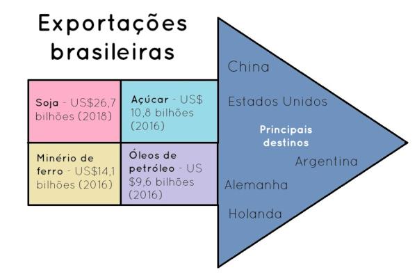
Taking as a reference the last La Niña event, which took place between 2010 and 2012, it is possible verify some of its consequences for the climate and the economy, especially for activities agricultural. In the case of sugarcane production, the reduction in rainfall in the Center-South helped reduce the sugarcane crop. cultivation, which could also be felt in the increase in the prices of ethanol, a fuel made from cane. It should be noted that the increase in ethanol prices is not only related to the La Niña phenomenon, but to a combination of factors, such as increased demand for fuel, increased vehicle manufacturing “flex” and of ethanol exports made by Brazil.
The Brazilian soybean production, despite maintaining its expansion process, was also limited by the droughts caused by the La Niña phenomenon in the highlighted period. Even the United States, a country that has modern and precision agriculture, suffered losses in its wheat production practiced in the southern plains thanks to droughts related to La Niña.
Julio César Lázaro da Silva
Brazil School Collaborator
Graduated in Geography from Universidade Estadual Paulista - UNESP
Master in Human Geography from Universidade Estadual Paulista - UNESP


