
THE altitude is the vertical distance between a certain point or object on the surface of the planet Earth and the mean sea level, which is a fixed reference. It is a measure used in the description of the relief and that can be obtained through the altimeters and also the GPS devices. THE climate of a region is directly influenced by its altitude, which acts together with other climatic factors.
Check out our podcast: What do I need to know about weather factors
altitude summary
Altitude is the vertical distance between any point on the earth's surface and the sea surface (sea level).
Altitude is measured using an instrument called an altimeter.
Altitude and height are different concepts. Height refers to the vertical measurement from the top to the bottom of an object, with no fixed reference.
Altitude directly influences the climatic dynamics of places, and is therefore considered a climate factor.
The Brazilian territory has modest altitudes due to its ancient geological substrate, shaped by the action of erosive agents, and relatively stable.
What is altitude?
The altitude can be defined as the vertical distance between any point on the earth's surface and sea level. It is expressed in meters, being a measure widely used in geomorphology for the characterization of the different forms of relief.
How is altitude measured?
The altitude measurement is made with the aid of an instrument called an altimeter.It can work in different ways, the most common being through atmospheric pressure. In this case, the altimeter contains a barometer inside, formed by a compartment that expands or contracts according to the pressure of the air that fills it. This movement causes the spring to react and moves the pointer, which indicates the altitude of a place, in meters or feet.
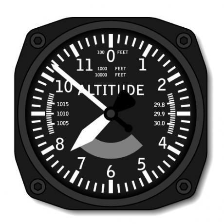
The altimeter can also obtain information from radars or global positioning systems (GPS), which collect information through satellites. Currently, modern instruments for locating on the earth's surface, such as the navigation gps, already indicate, in addition to the geographic coordinates, the altitude of the point we are at.
Brazil altitude
THE Brazil is located in an area of very old and relatively stable geological formation, without orogenetic movements responsible for the constitution of the modern folds. As a result, exogenous forces are the main shapers of the Brazilian relief, predominating processes of erosion and sediment deposition.
Thus, plateaus, plains and depressions are the three main landforms observed in the territory, with most terrains presenting modest altitudes ranging from 200 to 600 meters above sea level.
Despite that, the highest point in Brazil is Pico da Neblina, which has an altitude of 2995.3 meters and is located in the state of Amazonas, in the northern region of the country, close to the border with Venezuela. It is inserted in the unit of the North-Amazonian residual plateaus. Furthermore, the highest altitude city in the country is Campos do Jordão, in the state of São Paulo, located at 1628 meters above sea level.
Along with Campos do Jordão, they make up the list of highest cities in Brazil:
Camanducaia (Minas Gerais): 1554 meters;
Senador Amaral (Minas Gerais): 1505 meters;
Urupema (Santa Catarina): 1425 meters;
Bom Repouso (Minas Gerais): 1360 meters.
What is the difference between altitude and height?
Although they seem similar concepts, it is necessary to pay attention to the differences between the definitions of altitude and height. This is because altitude is measured based on the sea surface, that is, this reference is fixed and used to determine the altitude of any point or object. In turn, the height corresponds to the vertical measurement of a body, point or object from its base to its top. It is the individual dimension that has as reference the extreme points of the same object.
Relationship between altitude and climate
Altitude is what we call the climate factor or climatic factor, since it has a direct influence on climate characteristics of a locality. This happens due to atmospheric pressure, which is different in higher and lower areas, and also due to the incidence of winds and precipitation.
In areas of higher altitude, the air is thin and the atmospheric pressure is lower. Under these conditions, temperatures tend to be lower, due to the lower heat retention capacity. For every 100 meters of altitude, the temperature decreases by 0.6 °C. Thus, the higher the altitude of a place, the colder it is. Furthermore, there is a greater occurrence of winds and precipitation in the form of rain and snow.
On the lower altitude areas, the air column is larger, which results in higher atmospheric pressure. Temperatures tend to be higher due to the greater heat retention capacity.
See too:Weather Factors and Elements — What's the Difference?
What is the difference between altitude and latitude?
Both altitude and latitude are factors that influence the climate of an area, each acting in its own way, since they are different concepts.
While altitude corresponds to the elevation of an area above sea level, Latitude refers to the position of an area on the Earth's surface with respect to the parallel of 0°, which is the equator. Latitude is defined as the distance in degrees from any point on the planet Earth with respect to the Equator and is used to determine geographic coordinates, which are fundamental for location and orientation in space.
With regard to its influence on the climate, areas of lower latitude receive a greater incidence of heat from the Sun, while that the regions further away from the equator are much colder, due to the lower incidence of solar rays.
Exercises solved about altitude
question 1
(Fuvest) Mount Everest is the highest peak on the planet, located in the Himalayas, on the border of China and Nepal, with an altitude of 8,848 meters. It has five weather stations at different altitudes operating since 2019, including the highest station on the planet (8,430 m), which records valuable data for climatology. This project was led by Dr. Paul Andrew Mayewski, geographer and climatologist, whose team designed and trained for months to install the weather station in such an adverse condition in less than 90 minutes.
Available in https://www.climadeensinar.com.br/. Adapted.
The difficulty of installing the station at the mentioned altitude is due to:
A) the high humidity conditions resulting from the melting of snow.
B) the occurrence of intense rains, which increase the risk of avalanches.
C) the reduced temperatures and low oxygen concentration at this altitude.
D) the shorter days at this altitude, which reduces sunlight.
E) the high atmospheric pressure, which produces intense winds at that altitude.
Resolution:
Alternative C
The air in higher altitude areas is thin, making breathing difficult. In addition, the temperatures recorded at the highest points in the Mount Everest are very low. For this reason, it was difficult to install the station.
question 2
(PUC-Rio)

Available in:. Accessed on: 30 Jul. 2012.
The temperature variation observed in the cartogram above is explained:
A) the difference in atmospheric pressure at different altitudes.
B) by correcting the highest latitude for longitudinal variations.
C) by the variation in longitude that affects the change in latitude.
D) lower pressure concentration at lower altitudes.
E) by climate change in the ice sheets at higher altitudes.
Resolution:
Alternative A
Thermometers indicate the reduction in temperatures with increasing altitude, which is due to the difference in atmospheric pressure.
By Paloma Guitarrara
Geography teacher