O Mato Grosso do Sulis a federative unit located in Midwest region of Brazil. Its capital is the municipality of Campo Grande, the most populous in the state. Its natural landscape is predominantly composed of two biomes, the Cerrado and the Pantanal, in addition to a mostly flat relief. It is a large agricultural producer, with emphasis on cattle raising and grain cultivation.
Read too: Regions of Brazil - division of territory according to similar characteristics
General data for Mato Grosso do Sul
Region: Midwest
capital: Large field
Government: representative democracy
Areatterritorial: 357,147.994 km² (IBGE, 2020)
Population: 2,809,394 inhabitants (IBGE, 2020)
Densitydemographic: 6.86 inhab./km² (IBGE, 2010)
spindle: Amazon Standard Time (GMT -4 hours)
Climate: tropical
Do not stop now... There's more after the advertising ;)
Geography of Mato Grosso do Sul
Mato Grosso do Sul is located in the Center-West region of Brazil, with the city of Campo Grande as its capital. Its territorial area is 357,147,994 km², which places it in sixth position among the largest federal units in the country.
The southern territory of Mato Grosso borders:
to the north, with the Mato Grosso
northeast, with Goiás
to the east, with Minas Gerais and Sao Paulo
to the southeast, with the Paraná
To the west, the state borders two countries: Bolivia, in a narrow strip to the northwest, and Paraguay.
Mato Grosso do Sul climate
The predominant climate type in Mato Grosso do Sul is the Tropical, with variations between the north and south of the territory. While in northern areas the average temperature is around 24.5 ºC, in southern lands annual temperatures are lower, ranging from 18 ºC to 20 ºC.
The volume of rainfall is considerably greater in the center of the state, reaching 1500 mm per year. In other areas, metrics range from 1000 mm to 1250 mm per year. Considering the climate, rainfall is concentrated in the months of summer, being the winters drier.
Mato Grosso do Sul relief
The Mato Grosso do Sul relief is quite dissected and marked by low and medium altitudes, being characterized by the predominance of plateaus and plains.
According to the classification proposed by Jurandyr Ross, most of the state is included in the unit of Planaltos and çslaps of Bacia do parana, which extends through the central and eastern lands. Another plateau domain that forms its relief is the Planaltos and smistakes rUpper Paraguay rivers.
THE dMiranda's epression covers a narrow strip to the west of the state, a region in which the PPantanal wool, where the altitudes are between 100 m and 200 m. It is the largest wetland on the planet.
The highest point in the state is Morro Grande, with an altitude of 1065 meters and located close to another important mountainous area in Mato Grosso do Sul, the Serra da Bodoquena.
Mato Grosso do Sul vegetation

The vegetation cover of the state is composed of features characteristic of three biomes. The main one is the Cerrado, which covers the largest portion of the Mato Grosso do Sul territory.
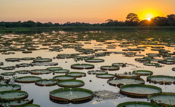
Across the western range of the state and especially in the northwest, there is the predominance of wetland. In this biome it is possible to find plant species that make up other natural frameworks, such as the Cerrado itself, Amazon and Atlantic Forest. A small part of the flora is endemic, that is, it consists of species originating from the Pantanal biome. With large surfaces that are permanently flooded, aquatic plants such as water lilies stand out.
In the southeast of the state, there is an area covered by Atlantic forest.
See too: Fires in the Pantanal – anthropic and natural actions that threaten this biome
Mato Grosso do Sul hydrography
The state's drainage system is divided between two hydrographic basins: Paraguay and Paraná, respectively to the west and east in the territory of Mato Grosso do Sul. Its watershed are the Maracaju and Bodoquena mountains, in the center-south of the state. The main rivers are: Aquidauana, Apa, Aporé, Miranda, Paraguay, Paraná, Paranaíba and Sucuriú.
Map of Mato Grosso do Sul

Demographics of Mato Grosso do Sul
Mato Grosso do Sul é the state fewer populationsO of the Midwest, with 2,809,394 inhabitants, equivalent to 17% of the entire population of the region. In addition, it gathers a share of 1.3% of the Brazilian population, ranking 21st among the states. At the time of the 2010 Demographic Census, the population distribution was 6.86 inhabitants/km². With data from 2020, there is a value of 7.86 inhab/km².
Most of the population of Mato Grosso do Sul lives in cities, being the 85.63% urbanization rate. Campo Grande, capital of the state, is the most populous municipality, with 906,092 inhabitants. Next is Dourados, with 225,495 inhabitants.
The state has the second largest contingent of self-declared indigenous population in the country, which in 2010 was 73,295 people. This value represented 9% of the entire self-declared indigenous population in Brazil, according to the 2010 IBGE Census. The population of the state is also composed of migrants in other Brazilian states, like Minas Gerais and Paraná, and countries like Bolivia, Paraguay, Portugal, Japan, Lebanon, among others.
Geographical division of Mato Grosso do Sul
The territorial division of the state of Mato Grosso do Sul is made through intermediate and immediate geographic regions, according to the IBGE classification in force since 2017. Thus, the 79 municipalities of Mato Grosso do Sul are grouped into 12 immediate regions. These, in turn, form the three intermediate regions listed below:
Campo Grande, which covers the entire central and eastern portion of the state;
Dourados, to the south and part of the southeast;
Corumba, to the west.
Flag of Mato Grosso do Sul

Economy of Mato Grosso do Sul
The Gross Domestic Product (GDP) of Mato Grosso do Sul is R$ 106.96 billion, which corresponds to the lowest GDP in the Midwest region of the country and the 15th on the national scale. The state's economy is equivalent to 1.5% of the Brazilian GDP.
According to IBGE data for 2018, the service sector corresponds to the main portion Mato Grosso's GDP, with 40.09%. Following is the industry, with a share of 22.26%, and, finally, agriculture, which accounts for 19.02% of the added value.
Mato Grosso do Sul is a great grain producer, of which soybeans are the flagship. In addition to this, other crops are important to the state's revenues, such as corn, sugarcane, cotton and wheat. THE cattle ranching is also one of the outstanding activities of primary sector. The state industry is made up of branches such as paper and cellulose, civil construction, food, and chemicals.
In the service sector, the tourism and the activities linked to it, which is mainly due to the beautiful natural landscapes found in the Pantanal.

Government of Mato Grosso do Sul
Mato Grosso do Sul consists of a representative democracy. State elections are held every four years so that the population can nominate their representatives. One of them is the governor, who heads the executive branch of the state. The Legislative is formed by three senators, eight federal deputies and 24 state deputies.
Mato Grosso do Sul Infrastructure
Important federal roads cross the territory of Mato Grosso do Sul and promote its integration with other Brazilian states and also with neighboring countries, reaching its border region. In this case, the BR-262, which goes to the city of Corumbá, close to the border with Bolivia, stands out. Besides it, the BR-163, BR-158, BR-060, among others, pass through the state.
O waterway transport occurs mainly through the Paraguay-Paraná waterways, which crosses the northwest and part of the west of the Mato Grosso do Sul to the border with Paraguay, and Tietê-Paraná, on the border with the state of São Paul. In addition to the waterways, two branches rail serve the state, among which is the Malha Oeste, which also extends across the territory of São Paulo.
Mato Grosso do Sul's main airport is in the capital, Campo Grande.
Read too: What is the relationship between infrastructure and development?
Culture of Mato Grosso do Sul
The cultural manifestations of Mato Grosso do Sul come from the traditions and customs characteristic of the peoples that make up its population, such as Africans, Portuguese, migrants from neighboring countries, such as Paraguayans and Bolivians, as well as Hispanics, Asians, among others. The main influence, however, comes from the indigenous populations..
O craft work is one of the expressions that brings with it the identity of the various indigenous peoples who live in Mato Grosso do Sul. The pieces are made with raw materials such as straw and clay.
many of the festivities of the state are directly linked to local or regional production as well as religious reasons. We can mention: Feast of the Divine, Procession of the Navigators, Feast of Fish, Bath of São João, Feast of the Sobá, among others.
Some typical dishes are sobá, pork on the roller, pantaneira fish and rice with guariroba. Tereré is one of the typical beverages of Mato Grosso do Sul, which includes crushed mate tea and cold water.
History of Mato Grosso do Sul
Mato Grosso do Sul became a state in the year of 1979, when its separation from Mato Grosso was made official. The movement for the division of territories began to take shape much earlier, in 1889, when politicians from Corumbá, in the northwest of the current state, proposed that the capital of Mato Grosso be transferred to this City. At the time, the seat of government was in Cuiabá, which is still the capital of Mato Grosso today.
Initially supported by the elites (mostly farmers), from the 1930s onwards, the separation movement winsor support ofand part of military, and Campo Grande became its main political center.
In the Estado Novo, through the policy known as "west march", was created, in 1943, the tPonta Porã Territory, aiming to protect the Brazilian border, and thus leaving the city of Campo Grande, which is in the center of the current state, out of its limits. The dissolution of that territory happened a short time later, in 1946, in the government of Eurico Gaspar Dutra.
Mato Grosso do Sul was created on October 11, 1977, through the enactment of Complementary Law 31 by the then president Ernesto Geisel, who also named the first state governor, Harry Amorim Costa. This took office on January 1, 1979, the year in which Mato Grosso do Sul officially became a state.
By Paloma Guitarrara
Geography teacher
Mato Grosso do Sul is a Brazilian state located in which regional complex?
The state of Mato Grosso do Sul has 78 municipalities. Check the alternative that indicates the capital of Mato Grosso do Sul.


