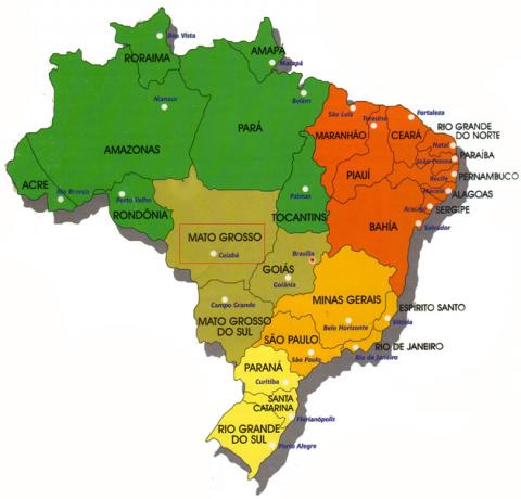
Espírito Santo has a territorial extension of 46,098,571 square kilometers, divided into 78 municipalities. According to the population count, carried out in 2010, by the Brazilian Institute of Geography and Statistics (IBGE), the state has a total of 3,514,952 inhabitants.
Located in the Southeast region, main responsible for the national economy (accounting for 56.4% of the the country's GDP), Espírito Santo contributed, in 2008, with 2.3% to the Gross Domestic Product (GDP) Brazilian. At the state level, this participation was 4%. This average is the lowest among the states in the Southeast.
The composition of Espírito Santo's GDP is as follows:
- Agriculture: 9.3%
- Industry: 34.5%
- Services: 56.3%
The service sector is the main economic activity in the state. Vitória, capital of Espírito Santo, is home to the ports of Tubarão and Vitória, the latter being one of the busiest in Brazil, a fact that drives this segment of the economy in the state.
Agriculture is based on the cultivation of rice, beans, coffee, vegetables, sugar cane and various fruits (in the areas on the coast there are banana, pineapple, papaya, passion fruit and lemon plantations, while in the mountains, strawberries are cultivated. and grape). Espírito Santo is the second largest producer of coffee beans in the Southeast, only behind Minas Gerais.
Do not stop now... There's more after the advertising ;)
The industrial sector, responsible for 34.5% of the state's GDP, stands out in the food, wood, pulp, steel and textile segments.
Espírito Santo is a great exporter of iron, steel and granite, it is also the second largest producer of oil and natural gas in the country, its production is only inferior to that of Rio de Janeiro. With the discovery of large oil reserves in 2002, the state rose from sixth to second position among the holders of the largest reserves in the country. With the start of oil exploration in the pre-salt layer, the state will significantly increase its production.
Export and import data:
Exports:
Iron ore: 46%
Steel products: 25%
Cellulose: 10%
Granite: 6%
Coffee beans: 6%
Others: 7%.
Imports:
Mineral coal: 14%
Machines and equipment: 12%
Cathodes and other copper products: 9%
Yarns, fabrics and garments: 7%
Products from chemical industries: 6%
Equipment for cargo handling: 6%
Cars, tires and parts: 5%
Others: 34%.
By Wagner de Cerqueira and Francisco
Graduated in Geography
Brazil School Team
Holy Spirit - Southeast region
geography of Brazil - Brazil School
Would you like to reference this text in a school or academic work? Look:
FRANCISCO, Wagner de Cerqueira and. "Economy of the Holy Spirit"; Brazil School. Available in: https://brasilescola.uol.com.br/brasil/a-economia-espirito-santo.htm. Accessed on June 28, 2021.


