Sao Paulo is a Brazilian state of Southeast region. it is about the most populous federation unit in the country, with 46 million people, and also home to the city with the highest concentration of inhabitants in Brazil, which is its capital.
The state has a tropical climate and relief characterized by the presence of plateaus and depressions. Still in the 20th century, São Paulo became one of the main economic centers in Brazil.
Read too: Espírito Santo – fourth smallest Brazilian state in territorial extension
General data for São Paulo
Region: Southeast
capital: Sao Paulo
Government: representative democracy
Areatterritorial: 248,219.481 km² (IBGE, 2020)
Population: 46,289,333 inhabitants (IBGE estimate, 2020)
Densitydemographic: 166.23 inhab./km² (IBGE, 2010)
spindle: Brasília Standard Time (GMT -3)
Climate: tropical
São Paulo geography
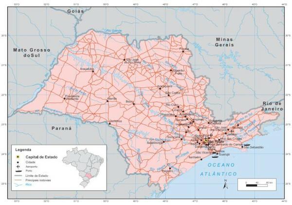
São Paulo is in the Southeast region of Brazil. It has a territorial area of 248.21 thousand km², making it the 12th Brazilian state in size. to the east, has a coastal strip of approximately 622 km. Does chevron:
to the north, with Minas Gerais
to the east, with Rio de Janeiro
south and southwest, with Paraná
to the west, with Mato Grosso do Sul
São Paulo climate
The predominant climate in the state of São Paulo is the Ttropical, with variations in the higher portions of the territory (Tropical de Altitude) and also in coastal areas (Tropical Atlantic).
In general, you winters are milder and the summers they are hot. Average temperatures in the state are between 18 ºC and 22 ºC, with the west region being considerably warmer than the higher lands and east. Winters tend to be dry in most parts of São Paulo, and in the summer, there is the rainy season. Annual rainfall exceeds 2000 mm on the coast, while it varies from 1500 mm in central areas to 1000 mm or less in western cities.
Relief of São Paulo
The relief in São Paulo is formed by plateaus and depressions, concentrating the highest elevations in the eastern portion of the territory, close to the coast. Altimetric averages range from 300 m to 900 m.
According to the classification proposed by Jurandyr Ross, the São Paulo relief can be divided into three morphological units. The first, which extends to the west, corresponds to the Plateaus and Plateaus of the Paraná Basin. Covering the central strip of the state from north to south, we have the Peripheral Depression of the East Rim of the Paraná Basin. To the west of this unit are the East-Southeast Plateaus and Mountains.
The main elevations in the state are the Serra do Mar and Mantiqueira, located to the east. The peak of the Marins is located in Mantiqueira, with 2420 meters. On the border with Rio de Janeiro, is the Pedra da Mina, at 2798 meters of altitude.

Vegetation of São Paulo
At plant formations characteristic of the thick (32.7% of the state area) and of the Atlantic forest (67.3%) cover the state, while mangroves and sandbanks are found on the coast, in addition to pioneer formations in wetlands, both on the coast and in the fluvial zones.
São Paulo hydrography
São Paulo's drainage system is divided between the hydrographic basins of the Paraná It's from Southeast Atlantic. O Tiete river is the main one of the state, crossing it from northwest to southeast. Other important rivers are the Grande, Paraíba do Sul, Paranapanema, Mogi Guaçu, Piracicaba and Ribeira do Iguape.
See too: São Francisco River – one of the most important water courses in Brazil
Sao Paulo map

São Paulo Demographics
The state of São Paulo is the most populous of the Brazil. According to the estimates of the IBGE for 2020, the population of São Paulo is 46,289,333 people, equivalent to 21.9% of the Brazilian population. THE demographic density of the state was 166.23 inhab./km² at the time of the 2010 Census. Currently, this value reaches 186.48 inhab./km², considering that São Paulo has gained more than five million inhabitants in a decade.
The state's urbanization rate is 95.9%. The city of São Paulo is its most populous municipality and also the largest capital in the country, with today 12,325,232 inhabitants. Two other municipalities have a population of over one million inhabitants: Guarulhos, in the Metropolitan Region of São Paulo, and Campinas. Also noteworthy are São José dos Campos, São Bernardo do Campo and Santo André.
The population of the state has been going through a gradual process of aging, characterized by an increase in the number of people aged 65 and over and a reduction in the number of people under 15 years of age. Life expectancy at birth is 78,9 years old, according to the IBGE.

São Paulo geographic division
The state of São Paulo is composed of 645 municipalities. IBGE groups these territorial units into 53 immediate geographic regions, which are subdivided into 11 intermediate regions:
Sao Paulo
Sorocaba
Bauru
marilia
Prudent President
Aracatuba
Sao Jose do Rio Preto
Ribeirao Preto
Araraquara
Campinas
São José dos Campos
São Paulo Economy
The Gross Domestic Product (GDP) of São Paulo is the largest among Brazilian federative units. According to IBGE, the São Paulo GDP is R$ 2.21 trillion, a value that corresponds to around 31.6% of Brazil's GDP. It is the only state to register a value that exceeds billions of reais.
O tertiary sector leads the economy of São Paulo, with greater participation related to trade and activities related to the financial, insurance and other sectors included in the same branch. a portion of 67.48% of the state's GDP it comes from this sector, with the exception of public administration, as indicated by IBGE data.
THE The state's industry is very broad and diversified., made up of a series of industrial centers that are well distributed spatially and that are specialized in different sectors, such as the production of sugar and alcohol, aerospace, automotive, leather and shoes, chemicals and petrochemicals, textiles, pharmaceuticals, and food and drinks.
Agriculture is responsible for a very small slice of GDP, although its activities are part of some of the most important production chains in the state. The highlights in this sector are the cultivation of sugar cane, coffee, cotton, corn, soybeans and fruits, such as oranges, in addition to cattle herds and the production of meat and milk.
See too: Agrosystems - set of production techniques in the agrarian space
Government of São Paulo
São Paulo is a representative democracy, which means that the population periodically elects its governors, every four years, through state elections. The head of the executive branch is the governor. The Legislature is represented by three senators, 70 federal deputies and 94 state deputies.
Flag of São Paulo

São Paulo Infrastructure
O road transport is the main modal used for the displacement of people and cargo in São Paulo. The state has a dense road network of 37 thousand km, counting the federal and state roads. Among the federal roads that cross the territory of São Paulo are: a stretch of the BR-050 known as Rodovia Anhanguera (SP-030), BR-101, BR-116, BR-153, BR-364 and others.
The São Paulo railway network is important for cargo transportation derived mainly from the primary sector exporter, connecting the producing areas with other modes, such as Tietê-Paraná Waterway, and with ports in both São Paulo and neighboring states. The Port of Santos, located on the coast of São Paulo, is currently the main national export route and one of the largest port complexes in the Latin America.
In the metropolitan region of São Paulo and in the city of Campinas, in the interior of the state, three of the largest São Paulo airports, which are, respectively, Guarulhos, in the city of the same name, Congonhas, in the capital, and Viracopos.
THE energy matrix state is composed mainly of hydroelectric power., highlighting also the biomass derived from sugarcane as one of the renewable sources used in the region.
São Paulo Culture
The culture of São Paulo is quite plural, which is due to its diverse population composition. There are aspects derived from indigenous, African, European and other parts of the world. Currently living in São Paulo more than three millions of immigrants who came from other regions of the country and miscellaneous nations, directly contributing to the cultural diversity observed in the state.
A series of regional festivals and folkloric and religious celebrations, like the Fthese Junited, Folia de Reis, Feast of the Divine, Feast of Our Lady Aparecida and others. In the capital, the Cultural turn has become a fixture in the events calendar and brings together several presentations in various spaces in the city.
O craftsmanship, in addition to being a cultural manifestation that expresses the identity of a particular group, it has become an important source of income in several areas of the state. The highlights are ceramics, sculptures made in wood, crochets, various braids characteristic of the Paraíba Valley, and various other works that use natural raw materials.
The state's traditional dish is the famous “virado à paulista”.

History of São Paulo
Indigenous populations were predominant in the territory of São Paulo when the first Portuguese arrived, which happened right at the beginning of colonization. Martim Afonso de Souza landed on the coast of São Paulo and founded Vila de São Vicente in 1532. The settlement of lands beyond the coastal strip began with the Jesuit priests of the Society of Jesus, who built the so-called Colégio São Paulo de Paraitinga in 1554. The building is located in the current historic center of the city of São Paulo under the name Pátio do Colégio.
São Paulo was the place of departure of expeditions known as Bwalkers, which had as objectives the capture of indigenous people to become enslaved labor and the discovery of precious metals in the interior of Brazil in the 17th and 18th centuries.
The economic development of the region accelerated with the introduction of coffee plantations in the interior paulista, in the 19th century. With the abolition of slavery at the end of the period, the entry of immigrants into the state intensified. The coffee economy enabled a large accumulation of income and the rise of both the transport infrastructure, with the advent of railroads, and industry.
The urbanization process intensified in thes centurys XX and XXI, at the same time that there was an expansion and diversification of the São Paulo industry, consolidating São Paulo as one of the main economic and industrial centers in the country.
By Paloma Guitarrara
Geography teacher

