
Rondônia is one of the 27 federation units in Brazil and integrates the rnorthern region. Inserted in the Amazon biome, the state's climate is the Hot and Humid Equatorial. Its vegetation cover is composed of forests and Cerrado species are found in some areas.
The Madeira River flows through the state, with little hilly terrain, on which the Madeira waterway is located, through which passengers and cargo are transported. Extractive activity is of great importance in the state's economy, with emphasis on the production of rubber and wood. In agriculture, soy is today the main crop.
Read too: Amapá - state in the North of Brazil located in the Hemisphere North and South
Rondônia general data
Region: North
capital: Porto Velho
Government: Marcos José Rocha dos Santos (2018-2022)
Areaterritorial: 237,765.240 km² (IBGE, 2019)
Population: 1,796,460 inhabitants (IBGE, 2020)
Densitydemographic: 6.58 inhab/km² (IBGE, 2010)
spindle: GMT -4 hours (Amazon Standard Time)
Climate: Wet Equatorial
Rondônia geography
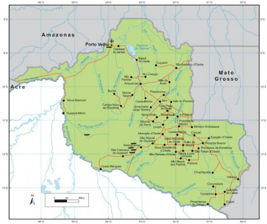
the state of Rondônia is located in the western portion of the northern region of Brazil. In national territory, it borders, to the north and northwest, with the Amazons and Acre, and, to the east and southeast, with the Mato Grosso. To the west the state borders the Bolivia. It has a territorial extension of 237,765.240 km², and is located in the Amazon biome. Despite this, Cerrado characteristics can be found in some parts of the territory.
Rondônia climate
With continentality as the main climatic factor, the predominant type of climate in the state is the ANDquatorial Hot and humid. Its main features are the high temperatures most of the year, with averages ranging from 24 ºC to 27 ºC, and maximum temperatures can reach 37 ºC. Rainfall rates are high and vary between 1600 mm and 2300 mm per year. The dry season is short and lasts approximately three months (between June and August).
In the south of the state, the climate differs slightly from the rest of the territory, presenting a seasonal drought a little longer, about four months, and average temperatures ranging between 21 °C and 24 °C °C.
Rondonia Vegetation
The vegetation cover of Rondônia is, in most of the state, marked by the characteristic species of the biome Amazon.Forests are predominant, such as the open rainforest, which covers more than half of the state's territory. There is occurrence of dense ombrophilous forest, campinarana and seasonal deciduous forest. In the southeast of the territory, close to the border with Mato Grosso, it is possible to observe patches of thick.
According to Embrapa|1|, in 2019, the state had 65.6% of its territory covered by native vegetation.
See too: Amazon rainforest - largest tropical forest in the world
Rondonia relief
The state is located in a region where there is a predominance of plains, and for that reason, it presents little bumpy relief and at altitudes ranging from 100 m to 300 m. There is occurrence of plateaus in the west of the territory, where elevations can vary between 600 m and 1000 m, such as the chapada dos Parecis and Pacaás Novos.
The highest elevation in the state is the peak of Tracoá or Jaru, with 1,126 meters.
Rondônia Hydrography
One of the main rivers in Rondônia is the Madeira, a tributary of the Amazon river and that it has more than 3 thousand km of extension, bathing other territories. Also noteworthy are the rivers:
Guaporé
Mamore
jaci-parana
Ji-Paraná
Jamari
Curassow Parana
![Navigable stretch of the Madeira River, in Porto Velho, the capital of Rondônia. [1]](/f/683ed2527d04917e964b18d9736cbbd8.jpg)
Rondônia Demographics
The population of Rondônia is 1,796,460 inhabitants, according to IBGE 2020 estimates. In the last Census, carried out in 2010, this figure was 1,562,409 people, placing the state among the least populated in the country. According to this same survey, the demographic density Rondônia has 6.58 inhab/km², ranking 20th among federation units.
The capital, Porto Velho, is the most populous municipality in the state., with 539,354 inhabitants. On the other hand, Pimenteiras do Oeste has the smallest population in Rondônia, with 2,148 people. Most of the population of Rondonia lives in urban areas, with a rate of urbanization 73.55% (IBGE, 2010).
Life expectancy in Rondônia is the lowest in the North region and the third lowest in the national territory, with 71.9 years registered for 2019. THE child mortality from the state went to Monday biggest in Brazil, also in 2019, with a rate of 18.8 deaths per live birth.
Rondônia map
Geographical Division of Rondônia
The territory of Rondônia is divided into 52 municipalities, which were grouped, until 2018, in micro-regions by the IBGE. The microregions, in turn, were part of two mesoregions.
We list the mesoregions and their respective microregions:
-
East Rondônia
→ Dawn of the West
→ Arichemes
→ Cacoal
→ Colorado of the West
→ Ji-Paraná
→ Vilhena
Guaporé Wood
→ Old Port
→ Guajará-Mirim
Currently, the geographic division is made by intermediate regions and immediate regions. Rondônia has two intermediate regions: Porto Velho, in the northern and northwestern portion of the territory, and Ji-Paraná, in the southern and southeastern portions. Each of them is divided into three immediate regions: Porto Velho, Ariquemes and Jaru; Ji-Paraná; Cacoal and Vilhena, respectively.
Also access: Socioeconomic regionalization of the world space
Rondônia Economy
OGross Domestic Product (GDP) of Rondônia was R$ 44.91 billion for the year 2018, according to the IBGE. The services sector contributed the largest share of this amount, corresponding to 68.2%. Industry accounted for 17.5% of GDP in 2018, a figure that had been going through a process of decline since at least 2010. Agriculture, in turn, corresponded to 14.2% of the state's revenue.
O extractivism is one of the main economic activities Rondônia, with the extraction and production of wood, rubber and metallic minerals.
The state's industry stands out in essential services, such as in electric power generation, mainly attributed to the Santo Antônio hydroelectric power plant. Another important branch is the transformation industry, with a focus on the production of food and beverages, and, finally, civil construction.
The state of Rondônia is one of the areas where the Brazilian agricultural frontier keep advancing in the North of the country, and soy crops have been gaining more and more space in the state's agricultural production.
Soy is the main agricultural crop in Rondônia. Other production highlights are: corn, cassava, coffee, rice, bananas, beans and cocoa. The state is a major producer of beef, the state's main export product, bee milk and honey.

Government of Rondônia
The seat of the government of Rondônia is established in the municipality of Porto Velho.
The state is governed by Marcos José Rocha dos Santos (PSL), whose vice-governor is José Atílio Salazar Martins (PSL), elected in 2018 for a four-year term. Rondônia is also represented by two senators, eight federal deputies and 24 state deputies.
Rondônia Infrastructure
in addition to state highways, Rondônia is crossed by six federal roads, among them the BR-364, which extends from Acre to the interior of Sao Paulo, crossing the territory of Rondonia from northwest to southeast.
The main airport in the state is the Porto Velho International Airport. Among the regional airports are those of Ji-Paraná and Vilhena, in addition to others classified as local, complementary and private.
THE Madeira-Mamoré Railway (EFMM) it is located in the state and had its construction completed in 1912. It connects the capital of Rondônia to the municipality of Guajará-Mirim, on the border with Bolivia.
The state also has theHMadeira waterway, considered the second most important in the North region of the country. Through it, passengers and cargo are transported, mainly from agricultural production, mineral oils and fuels.
Rondônia culture
The cultural aspects of the state reflect the diversity of its population, made up of indigenous peoples and migrants from different parts of Brazil.
Among the traditional festivities are the Arraial Flor do Passion Fruit and the Feast of the Divine. It is located in Rondônia, in the capital Porto Velho, the Jerusalem of the Amazon, one of the biggest scenographic cities in the world and where the reenactment of the Passion of Christ takes place during Holy Week.
O craftsmanship it is also an important cultural manifestation of the state. In cooking, there are dishes such as tacacá, stew, buriti jam and cupuaçu pie.
![Handicraft fair at the Madeira-Mamoré warehouse in Porto Velho, Rondônia. [1]](/f/ea421a50710c99a42a5d1efd385dd590.jpg)
Rondônia history
The exploration of the territory that we know today as the state of Rondônia began in the 16th century. However, the its consolidation began with the Treaty of Petropolis, signed between Brazil and Bolivia, which incorporated Acre into the national territory and established the construction of the Madeira-Mamoré railway, which would link Brazil to the neighboring country. THE EFMM construction attracted workers from other countries and regions of Brazil.
In 1943 the Federal Territory of Guaporé was established. During this period, the rubber cycle, which attracted a new wave of migrants.
As a tribute to Marshal Cândido Rondon, in 1956, the area was renamed Federal Territory of Rondônia. In the 1960s, workers came to the territory for the opening of BR-364 (BR-29 at the time). In the 1970s and 1980s, a large contingent of migrants from other regions of the country arrived in the territory.
THE creation of the andstate of Rondônia date of December 22, 1981, and Porto Velho was established as its capital.
Note
|1| Rural properties in Rondônia allocate 6.7 million hectares to native vegetation. EMBRAPA – News, September 23 2019 (Click here and access).
Image credit
[1] Vinicius Bacarin / Shutterstock
By Paloma Guitarrara
Geography teacher