The GPS (Global Positioning System) is formed by three segments: space, control and user.
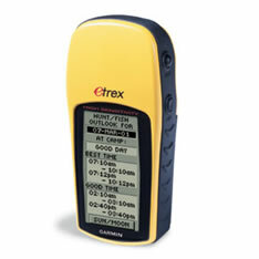
Space consists of 24 satellites distributed in six orbital planes. The control segment is responsible for monitoring satellite orbits. Finally, the user's segment is the GPS receiver, responsible for capturing the signals provided by the satellites.
This navigation system makes it possible, through artificial satellites, to obtain geographic location information anywhere on the earth's surface and at any time of day.
The geographic location occurs due to the radio emission from the satellites, which are captured by GPS receivers on Earth, where the information is decoded and the latitude, longitude and altitude.
In human history, location techniques have always been used, many of them through natural factors such as stars, sun, wind, rock formations, among others. However, the Global Positioning System is extremely effective in obtaining information regarding location and geographic orientation. Provides geographic position anywhere on the planet.
Do not stop now... There's more after the advertising ;)

GPS Receiver Model
The Global Positioning System is a program that was developed by the US Department of Defense, with a cost of approximately 10 billion dollars. The first receiver was tested in 1982. The goal was for this to become the main navigation system for the US armed forces.
There are currently two fully functioning Satellite positioning systems, the GPS developed and maintained by the United States and the Glonass, developed in Russia. China is developing a system called Compass. Another system being implemented is the European Galileo.
The development of other satellite positioning systems is of fundamental importance for users, as GPS, a technology developed and controlled by the US Department of Defense limits information intended for civilians, and in case of wars involving that country, the signal emission may be even more restricted.
By Wagner de Cerqueira and Francisco
Graduated in Geography
Would you like to reference this text in a school or academic work? Look:
FRANCISCO, Wagner de Cerqueira and. "GPS - Global Positioning System"; Brazil School. Available in: https://brasilescola.uol.com.br/geografia/gpssistema-posicionamento-global.htm. Accessed on June 27, 2021.


