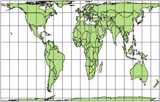
THE Peters projection it is an equivalent cylindrical cartographic projection, that is, it maintains the proportion of the areas represented, but alters their shapes. It is often called Gall-Peters projection, since it would have been first conceived by James Gall, in 1885, and taken up in the second half of the 20th century by the German historian Arno Peters.

Peters or Gall-Peters projection **
There is some controversy surrounding this projection, since, in addition to technical propositions, it also has a political nature, for expand the areas of the southern countries, whose majority of the countries are underdeveloped, and reduce the areas of the northern countries, with the majority developed. Furthermore, in this planisphere, Africa is placed at the center of the map, as opposed to the Mercator projection, where Europe was at the center. This projection is often referred to as the “Third Worldist”.
However, his proposal was not well received by cartographers of his time, who elaborated three main criticisms. The first referred to the lack of scientificity in his work, which abdicated technical details to the detriment of political options; the main “fault” would be an error in the position of the 46º 2’ parallel that should be in the 45º position. The second criticism was related to the distortions of its equivalent projection, which left the continents “thinner” at Ecuador and “wider” at the poles, making location and displacement more difficult. The third and most serious criticism referred to the fact that Peters had supposedly plagiarized the real work of James Gall, little or nothing altering his original conceptions.
Do not stop now... There's more after the advertising ;)
Controversies aside, Peters' work was widely disseminated and disseminated throughout the world, especially after the release of his atlas, in 1992. In addition, organizations such as the UN and UNESCO have made extensive use of their planisphere in order to raise awareness among populations and developed countries on the issues of underdeveloped countries, such as hunger, violence and social exclusion.
Controversies and discussions involving cartographic projections such as Peters and Mercator are evidence that there is no more “correct” projection than the others. Each serves a different purpose, and it is up to the user to determine which is the most suitable.
__________________________
* Image Credits: Street Journal
** Image Credits: Maximilian Dörrbecker / Wikimedia Comons
By Rodolfo Alves Pena
Graduated in Geography
Would you like to reference this text in a school or academic work? Look:
PENA, Rodolfo F. Alves. "Peters Projection"; Brazil School. Available in: https://brasilescola.uol.com.br/geografia/projecao-peters.htm. Accessed on June 28, 2021.
