THE Robinson Cartographic Projection is an aphylactic cylindrical projection made by the North American cartographer and geographer Arthur Robinson (1915-2004) in the 1960s. It is classified as cylindrical, as its elaboration occurs as if the terrestrial globe was wrapped around a cylinder.
It is one of the best known cartographic projections in the world. In it, meridians are represented in curved lines or ellipse, while parallels remain in straight lines.
We know that all cartographic projections are distorted due to the fact that they are representations of the terrestrial sphere carried out in a plane. In this way, different elaborations were built. In the case of cylindrical projections, these elaborations are classified into two main types: similar or compliant and equivalent.
Similar projections try to correctly represent the shape of the continents, with the prejudice of distorting their areas, as in the case of Mercator projection. On the other hand, the equivalent projections try to conserve the areas, but with the distortion of their shapes, as in the case of the
Peters projection.The big advantage of Robinson's projection it is that she finds herself in the middle ground between these two types. It preserves neither the shape nor the correct area of the continents. However, it manages to minimize the distortions that occur in these two aspects.
Do not stop now... There's more after the advertising ;)
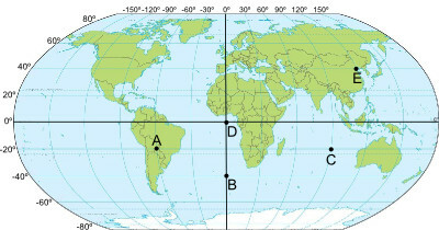
For this reason, it is ideal for maps that seek to represent the Earth's area as a whole and, thus, it is the most used projection in maps and atlases, being well known also as the world map from the earth. Note the image at the beginning of the text, you've certainly seen it in the most common representations of the earth map.
As we have already stated, this projection presents distortions both in the areas and in the shape of the continents. In the deformation of the areas, we can mention Antarctica and the regions of high latitudes (near the poles). Furthermore, the size of the area of the vast majority of continents is not in its correct proportions. It is interesting to observe how the areas more in the center of the projection are less distorted in relation to those located in the periphery of the map.
Thus, the main use of the Robinson Projection is not intended for technical performances and representations – as in the case of the Mercator projection, widely used in navigation -, but for didactic use, having been recommended for this purpose by several educational institutions throughout the world.
By Rodolfo Alves Pena
Graduated in Geography
Would you like to reference this text in a school or academic work? Look:
PENA, Rodolfo F. Alves. "Robinson's Projection"; Brazil School. Available in: https://brasilescola.uol.com.br/geografia/projecao-robinson.htm. Accessed on June 28, 2021.