O Paranáis a Brazilian state located in South region from the country. It has a predominantly humid subtropical climate and a plateau relief, with the highest elevations concentrated in the east of the state. Its economy is the fifth largest in the country, highlighting the transformation industry and grain production. On the coast of Paraná is the largest bulk port in Latin America, the port of Paranaguá. In the west, in turn, on the border with Paraguay, is located the Itaipu plant.
Read too: States of Brazil - autonomous federative units of our country
Paraná general data
Region: South
capital: Curitiba
Government: Carlos Roberto Massa Júnior (2018-2022)
Areatterritorial: 199,298.982 km² (IBGE, 2020)
Population: 11,516,840 inhabitants (IBGE, 2020)
Densitydemographic: 52.40 inhab/km² (IBGE, 2010)
spindle: Brasília Standard Time (GMT -3 hours)
Climate: Wet Subtropical
Do not stop now... There's more after the advertising ;)
Paraná geography
Paraná is one of the Brazilian states that make up the southern region of the country. It is limited to:
to the north, with Sao Paulo;
to the south, with Santa Catarina; and
to the west, with the Mato Grosso do Sul.
The western portion of Paraná also borders the Paraguay and the Argentina. To the east, the state has a brief coastline, with an exit to the Atlantic Ocean.
Paraná climate
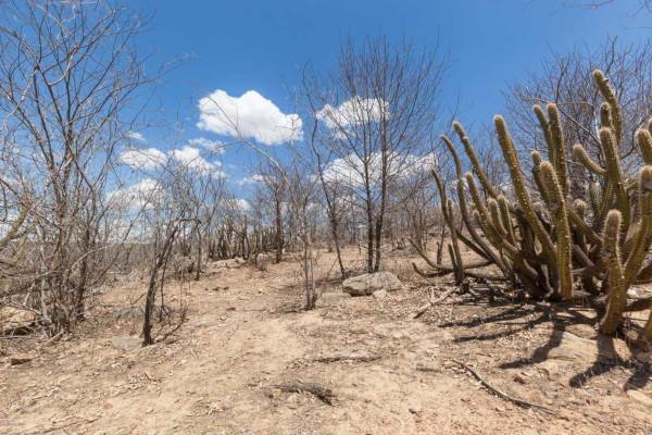
With most of its territory located below the Tropic of Capricorn, the predominant climate of Paraná is the subtropical Úkid. The highest temperatures are around 22 ºC, while the minimum can reach 14 ºC. The main local variations occur on the coast, which is hotter and more humid, and in the mountainous areas and higher portions of the plateaus, where lower temperatures prevail.
Rainfall rates vary between 1500 mm and 2500 mm. Some areas of the state experience the occurrence of frosts during the autumn it's the Winter.
Paraná Relief
Paraná can be divided into four morphosculptural units. In the west of the state, located in the Paraná sedimentary basin, is the third plateau of Paraná, whose average altitude is 170 meters. The terrain rises from the second plateau, whose average altitude exceeds one thousand meters. Immediately afterwards, there is the first plateau and the Serra do Mar unit, which precedes the flat land coastline.
The highest peak in Paraná and the South region is the Paraná peak, in the east of the state, with 1877 meters.

Vegetation of Paraná
Most of Paraná is inserted in the biome Atlantic forest. Its vegetation cover is mainly formed by seasonal forests and mixed ombrophilous. In the latter part of the domain of araucarias. In the east of the state, where the Serra do Mar is located, there are dense forests.
Paraná Hydrography
Intensely drained, the state of Paraná is part of two hydrographic regions: the South Atlantic and Paraná, where the river of the same name is inserted and whose waters serve as the driving force for the Itaipu plant. Also noteworthy are the Paranapanema River, a tributary of the Paraná River, and the Iguaçu River, the three being the longest courses in the state.
Read too:Hydrographic basins - part of the relief supplied by a river and its tributariesyou
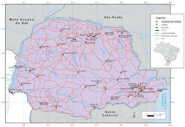
Paraná Map
Paraná Demographics
According to the estimates of the IBGE for 2020, Paraná has more than 11 million inhabitants, constituting the fifth Brazilian state in terms of population and the most populous in the South region. The largest portion of this population lives in cities, being the urbanization rate of 85.3%, according to the 2010 Census.
The capital, Curitiba, is the most populous municipality in the state, with 1,948,626 inhabitants. Among the Brazilian capitals, it represents the eighth largest population. The second municipality in Paraná with the highest concentration of inhabitants is Londrina, with 575,377.
Several ethnic groups make up the population of Paraná, the result of intense migratory flows that had the state as their destination. The presence of Germans, Arabs, Spaniards, Dutch, Italians, Japanese, Poles, Ukrainians, Portuguese, Africans as well as indigenous peoples stands out. In all, the population of Paraná is made up of 28 different ethnicities.
Geographical Division of Paraná
Until 2017, IBGE divided Brazilian states into micro-regions and meso-regions. The 399 municipalities in Paraná were divided into 39 microregions, which are grouped into 10 mesoregions. Are they:
Western Center of Paraná
Eastern Center of Paraná
South Center of Paraná
Metropolitan of Curitiba
Northwest of Paraná
North Central Paraná
North of Paraná Pioneer
West Paraná
Southeast of Paraná
southwest of Paraná
See too: Socioeconomic regionalization of the world space
Paraná Economy
The Paraná economy is the fifth largest in the country. O GDP of the state in 2018 was BRL 440,029 million, the equivalent to 6.28% of Brazil's GDP for the same year. The largest portion of this amount comes from the tertiary sector, which covers commerce and services (with the exception of public administration).
O secondary sector, that is, the industry, accounts for almost a quarter of the state's GDP. In addition, Paraná's industrial GDP has a share of just over 7% in the country. The main industry in the state is manufacturing, being also the third in the country in 2018. The highlight goes to food production, followed by vehicle assembly, Petroleum and derivatives, pulp and paper, chemicals, and wood.
Agriculture, in turn, is responsible for a share of 9.51% of the value added to GDP. Paraná is one of the main grain producers in Brazil, of which soybeans are the most important. In addition to it, the crops of corn and wheat stand out. When it comes to livestock, the state is a major producer of poultry and swine.
Government of Paraná
At the head of the executive branch of Paraná are the state governor and his deputy, both elected to their positions every four years. In the same election, representatives of the Legislature are chosen, which, in the state in question, is currently composed of three senators, 30 federal deputies and 54 state deputies.
Flag of Paraná

Paraná Infrastructure
It is on the coast of Paraná one of the most important Brazilian ports: the Portho of Paranagua, considered as the largest grain drainer in the Latin America. Its facilities serve, in total, 10 states in Brazil. Exports correspond to products from various economic sectors, ranging from wood and food to those derived from the mechanical industry. The great highlight is, however, with agricultural products.
In the west of the state, on the border with Paraguay, theufate HItaipu hydroelectric plant. It is the second largest hydroelectric plant in the world and has recorded successive records in energy production on a world scale. a portion of 10.8% of the energy consumed in Brazil comes from Itaipu, while the plant is responsible for 88.5% of energy consumption in Paraguay.

Paraná Culture
The culture of Paraná is derived from customs and traditions characteristic of the diverse origins of its population. Some of the more traditional manifestations are the fandango, which became popular mainly among caiçaras and fishermen, the Congo (or congada) and the cavalcades.
Among the celebrations are the Feast of the patron saint of Paraná, on November 15th, and the Festa da Luz, celebrated on September 8th. The Ethnic Folklore Festival is also held in the state.
Some of the typical dishes of Paraná are pinhão (which is araucaria seed), barreado, ounce meat (beef ground beef and seasoned and arranged in slices of black bread), mutton in the hole, and pierogi (original dish Polish).

History of Paraná
Paraná was declared as a province in the mid-19th century., more precisely in 1853. Prior to that, the territory of Paraná was known as the captaincy of Paranaguá, which was found incorporated into what would become the captaincy of São Paulo.
In the same period in which it separated from the captaincy of São Paulo, the yerba mate cycle, which led the state's economy at the time and was largely responsible for the development of some of its main transport networks. Still in the nineteenth century, a large flow of immigrants arrived in the state, from the
Germany;
Poland;
Sweden;
Russia;
Ukraine.
Over time, the wood and coffee cycles motivated the arrival of new migrants both foreigners and from other Brazilian states. The 1970s marked both the entry of soy in the state and the advance of the industrialization process.
By Paloma Guitarrara
Geography teacher