Cartographic projections are systems of geographic coordinates, constituted by meridians (imaginary semicircle drawn from a Earth pole to the other) parallels (imaginary lines parallel to the Equator Line), on which the spherical surface of the Earth.
This means that the spherical surface of the planet is therefore flattened through drawing, giving rise to a map. The construction of this system is made through mathematical and geometric relationships. The best known cartographic projections are:
- Cylindrical projection
- azimuth projection
- conical projection
readalso:What are parallels and meridians?
Main cartographic projections
Second Brazilian Institute of Geography and Statistics, the best known cartographic projection classifications are those that use the surfaces of a cone, plane or cylinder in order to plan the spherical area of the Earth.
→ Cylindrical projection
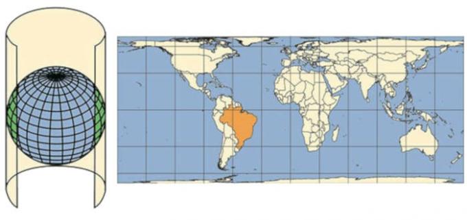
Cylindrical projection refers to the representation of the spherical surface of the Earth in a plane using as
base one cylinder that envelops the entire globe. In this projection, the geographic coordinates (parallel and meridians) are represented by straight lines that meet at right angles.There is conservation of form, directions and angles in it, but the surface proportion is distorted. It is common to choose this type of projection for world maps. As it approaches the poles, the deformations increase, so the polar regions are usually exaggerated in their presentation.
→ conical projection
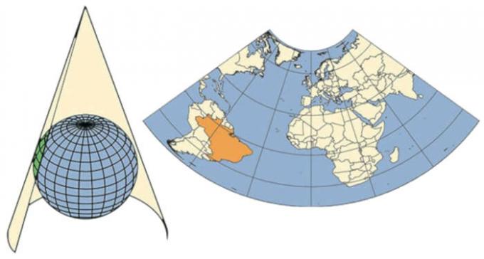
Conical projection refers to the representation of the spherical surface of the Earth projected onto a cone. Geographic coordinates originate from a single point. The meridians converge towards the polar regions, and the parallels form concentric arcs. The areas that are farthest from the parallel in contact with the cone present greater deformations. Usually this type of projection is used for represent regions of intermediate latitudes.
→ azimuth projection

Azimuthal projection, also called planar projection, refers to the representation of the spherical surface of the Earth on a flat surface touching the globe. The geographic coordinates in this type of projection form concentric circles. It is used to represent any point of the Earth, being more common the representation of the polar regions, that is, smaller areas of the globe. It is classified into three types: polar, equatorial and oblique.
Types of cartographic projections
There are several approximate representations of the Earth's spherical surface in a plane. They can be classified as to the projection surface (which are the most common and have already been mentioned above); as to the type of contact with the surface; as to properties; as to the method of elaboration of the tracing; or regarding the situation from the point of view.|1| The best known are:
→ contact surface
- Tangent: projection surface is tangent to the reference surface.
- drying: projection surface divides (splits) the reference surface into parts.
→ Property
- Equidistante: cartographic projection that does not present linear deformation, but the conservation of the scale real in a certain direction. There is deformation of the area and angles in it, conserving distances.
- According: cartographic projection in which there is conservation of angles and deformation of areas, especially in small regions. There is in it the intersection between geographic coordinates at right angles.
- Equivalent: cartographic projection that does not show deformation of the areas, that is, the proportion with the real area is preserved. However, there is distortion of the angles, causing deformities around a point, due to scale variation.
- aphylactic: cartographic projection that does not conserve angle, area or length, therefore, there is no conservation of properties. However, there is as little deformation as possible together.
→ projection surface position
- Polyconic: projection whose representation surface is a cone showing deformations at the center that increase as the area moves away from the central region. Used especially in representations of large areas from north to south.
- Transverse: projection in which the geographic coordinates are not shown in a straight line (except the equator line), mainly used to represent large areas from north to south.
- Normal: projection in which parallels appear as circles and meridians as straight lines, with a low level of deformation. Especially used in representations of large areas from west to east.
→ Tracing preparation method
- geometric: projection represented according to geometric principles, being divided into: gnomonic (point of view in the center of the Earth), stereographic (point of view in the plane contrary to the tangency of the projection plane) or orthographic (point of view in the infinite).
- analytics: projections represented according to mathematical formulations (calculations, tables, abacuses).
- Conventional: projections represented through calculations and tables.
knowalso: Map of Brazil: states, capitals and regions
Examples of cartographic projections
There are several types of projections according to the criteria already mentioned, but some of them are well known when the subject is representation of the world map. Meet three of them:
→ Mercator projection

THE Mercator projection, drawn up in 1569 by cartographer Gerhard Mercator, is of the cylindrical and one of the best known in the world. Geographic coordinates are plotted in straight lines that intersect at right angles. In this type of projection, there is conservation of the angles and deformation of the areas. The regions at high latitudes are exaggerated.
→ Peters projection

THE Peters projection, elaborated in 1973 by the German historian Arno Peters, is of the type cylindricalequivalent. Parallels are shown at intervals that descend from the Equator Line. Unlike the Mercator projection, the Peters projection presents the region of the underdeveloped and developing countries. In the east-west direction, there is flattening, while in the north-south direction, there is elongation. The main feature of this model is the conservation of areas and the deformation of angles and shapes.
→ Robinson's projection
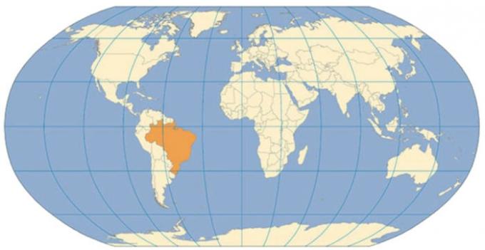
THE Robinson's projection, drawn up in 1961 by geographerArthur H. Robinson, is the type aphylactic and pseudocylindrical. In this type of projection, parallels are represented in a straight line and meridians in the form of concentric arcs. The map drawn up shows minimal deformation of areas and shapes, conserving angles. It is considered the best cartographic projection to represent the continental masses.
Know more: What are the elements of a map?
Why are cartographic projections distorted?
Due to the great difficulty of representing something spherical on a flat surface, cartographic projections usually present distortions, be they in the area, in the shape or in the angle. Thus, each projection, among the existing hundreds, prioritizes some aspect in its representation and will never be free from distortions, therefore, it will not faithfully represent the surface.
It can be said then that there is no ideal cartographic projection. The choice of each one will be related to the purpose of what you want to represent. The representation that presents the least problems with the alterations, and the closest to reality, is the globe.
Curiosities about cartographic projections

- According to the IBGE, the representation of Brazil is made through an equatorial cylindrical projection of Mercator and polyconic. The official mapping of the Brazilian territory is elaborated in the polyconic projection, which aims to reduce the deformation of the meridians as they converge.
- The emblem of United Nations Organizations is an example of azimuthal or plane projection. This projection is centered on the North Pole, extending to 60° south latitude.
Read too: Legend and symbology of maps
solved exercises
1) (UESC) Knowledge about cartographic projections and the use of maps make it possible to state:
a) The azimuthal projection provides a Eurocentric view of the world and, therefore, is no longer used.
b) The distortions of representation, in the cylindrical projections, are greater in Ecuador and smaller in the poles.
c) Peters' projection is the only one that does not intend to privilege any continent, because it rigorously reproduces reality.
d) The conical projection can only be used to represent large regions, because distortions are small between the tropics, therefore not representing the reality of the mapped areas.
e) Cartographic projections allow, in the construction of thematic maps, the meridians and the Earth parallels are transformed from a three-dimensional reality to a reality two-dimensional.
Letter e
The main objective of cartographic projections is to represent a three-dimensional area in a two-dimensional way. Choosing the type of projection will depend on the purpose of the map.
2) (FGV/2017) Considering cartography as a set of techniques, cartographic projections face the challenge of representing the geoid shape of planet Earth in a plane. As for the type of projection surface, the one whose distortions increase as we move away from the equator is called projection
a) polysuperficial.
b) conical.
c) cylindrical.
d) azimuthal.
e) polyhedral.
Letter C
In the cylindrical projection, as it moves away from the equator and approaches the poles, the deformation of the area increases, and therefore the poles are presented with exaggeration.
3) (UEL-PR/2015) In order to represent, as close to reality as possible, the geographic space, the scientists used cartographic projections. The most used are those of Mercator and Peters. Based on your knowledge of cartographic projections, tick the correct alternative.
a) In the Peters projection, the projection surface plane is tangent to the terrestrial sphere (azimuth projection); in Mercator projection, the projection surface plane is a cone (conical projection) surrounding the terrestrial sphere.
b) In the Mercator projection, the spacing between parallels decreases from the Equator to the poles, while the spacing between meridians increases from the central meridian.
c) In the elaboration of a cartographic projection, the Peters planisphere maintains the proportional distances between the elements of the map, increasing the length of the central meridian.
d) The Mercator projection is developed on a cylinder, the shape property being maintained. This projection shows a Eurocentric worldview.
e) In the Peters projection, the spacing between parallels increases from the Equator to the poles, while the spacing between meridians decreases from the central meridian.
Letter D
Peters and Mercator's projections are cylindrical. While Peters presents an exaggeration in underdeveloped regions, Mercator presents a Eurocentric view increasing the area of countries at the highest latitudes.
Grades
|1| Cartographic projections. To access, Click here.
By Rafaela Souza
Geography teacher
Source: Brazil School - https://brasilescola.uol.com.br/geografia/projecoes-cartograficas.htm