O Sergipe is a Brazilian state that integrates the Northeast region of the country. consists of the smallest unit of the federation in territorial extension. The capital of Sergipe is Aracaju, its most populous municipality. In total, the state has just over 2.3 million inhabitants. The predominant climatic types are semi-arid and humid tropical, respectively in the west and east of Sergipe territory. Orange juice is the flagship of exports in the state, while sugarcane leads agricultural production. In industry, the highlight is civil construction.
Read too: States of Brazil: what they are, capitals and general information
Sergipe General Data
• Region: North East.
• capital: Aracaju.
• Government: Belivaldo Chagas Silva (2018 – 2022).
• Territorial area: 21,938.184 km² (IBGE, 2020).
• Population: 2,318,822 inhabitants (IBGE, 2020).
• Demographic density: 94.36 inhab/km² (IBGE, 2010).
• spindle: Brasília Standard Time (GMT -3 hours).
• Climate: semi-arid and tropical hot and humid.
Sergipe geography
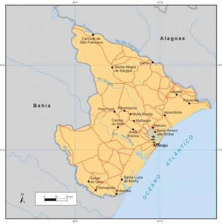
Sergipe is one of the Brazilian states that make up the RNortheast region. It is the smallest federation unit in the country, with an area of 21,938 km². It borders, to the north, with Alagoas; and to the west and south, with Bahia; to the east is the Atlantic Ocean. The state capital, Aracaju, is located on the coast.
Taking into account the sub-regions into which the Northeast is divided, the largest portion of Sergipe's territory is part of the Zona da Mata, to the east. Part of the west of the state is inserted in the Agreste, with a small area to the northwest integrating the northeastern Sertão. This classification helps us to understand some of the physiographic characteristics of the state.
Climate
The two predominant weather types in Sergipe are the semiarid, in the west, and the tropical hot and humid, to the east. In addition to high temperatures, the first is characterized by low rainfall, with averages that can be between 500 and 700 mm per year. In other areas, the summers are dry and the rains are concentrated in the autumn and winter months, which may exceed 1000 mm in some regions.
Relief
most of the Sergipe terrain integrates the domain of the Sertaneja Depression, which covers almost the entire west of the state. Relatively flat or undulating surfaces are interrupted only by the presence of residual relief. To the east of this area, the landscape is composed of hills, followed by the coastal plateaus and the flat land coastline.
The highest point in the state is in Serra Negra and has an altitude of 752 meters.
Vegetation
Sergipe is situated in two biomes, featuring vegetation cover characteristic of both. Are they the Atlantic forest, in the east, and the Caatinga, to the west, where species of medium and small size can be found, some of them adapted to long periods of drought. Between these biomes, there is a transition area.
Hydrography
The state is divided into six big watersheds, of which the São Francisco River Basin stands out. Other important rivers are: Japaratuba-Mirim, Sergipe, Vaza-Barris, Piauí and Real.
Sergipe Map
Sergipe Demographics
According to IBGE estimates for the year 2020, Sergipe has a population of 2,318,822 inhabitants. Because it has a restricted area, its demographic density it is high, at 94.36 inhab/km², according to the latest IBGE Census. Currently, this value reaches 105.69 inhab/km². The state is, therefore, one of the most populated in the country, albeit sparsely populated.
The 2010 Census indicates an urbanization rate of 73.51%. THE Sergipe's most populous city is its capital., Aracaju, with 664,908 inhabitants. Next is Nossa Senhora do Socorro, with 185,706 inhabitants. The smallest city in Sergipe is Amparo de São Francisco, with a population of 2,380.
Sergipe's population growth rate is 0.77%, higher than rates on a regional and national scale. Life expectancy in the state is 73.4 years and, although it has grown, it is lower than that recorded for the country (76.6 years).
Read too: São Francisco River — one of the most important Brazilian rivers
Geographical Division of Sergipe
the state of Sergipe is formed by 75 municipalities. Since 2017, IBGE has grouped these units into immediate geographic regions, which, in turn, make up the intermediate geographic regions.
Sergipe's territory is thus divided into two intermediate regions: Aracaju, which covers the east of the state, and Itabaiana, in the west. The region of Aracaju is composed of the immediate regions of Aracaju, Estância and Propriá. Itabaiana is formed by the immediate regions of Itabaiana, Lagarto and Nossa Senhora da Glória.
Sergipe Economy
O Gross Domestic Product (GDP) of Sergipe is R$ 42.018 billion (IBGE, 2018), placing the state among the smallest state economies. This value also represents 4.18% of the economy of the Northeast Region. The largest portion of this value corresponds to the service sector, followed by industry.
The industrial profile of the state is made up of civil construction - which represents almost a quarter of the industry Sergipe — food and chemical production — of which petrochemicals stands out — and production from non-minerals metallic. Therefore, the extractivism plays an important role in Sergipe's economy.
Also in the primary sector, we have agricultural production led by the cultivation of sugar cane. The state is also a producer of corn, cereals, oranges, cassava, beans, bananas, peanuts and milk. Among the various products intended for the foreign market are orange juice and leather.

Sergipe Government
Sergipe's Executive Branch is headed by the state governor (currently Belivaldo Chagas Silva) and his deputy governor, both elected by popular vote every four years. The Legislative, in turn, is exercised by three senators, eight federal deputies and 24 state deputies.
Sergipe Infrastructure
O Sergipe territory is crossed in the north-south direction by the BR-101, federal highway that extends for most of the Brazilian coast (between Rio Grande do Sul and Rio Grande do Norte). BR-325 connects the state to Pará, while BR-349, which reaches Aracaju, extends from the interior of Goiás. The main airport is in the capital and has national and international flights.
With regard to electricity, the largest portion of the energy generated in the state comes from hydroelectric plants, especially the Xingó Hydroelectric Plant and the Santa Cruz Plant. The state's energy matrix is also composed of wind, biomass and fossil fuels.
Sergipe Culture
Sergipe's cultural wealth is built from various manifestations, which have their origins in European traditions, especially Portuguese, African and traditional local populations.
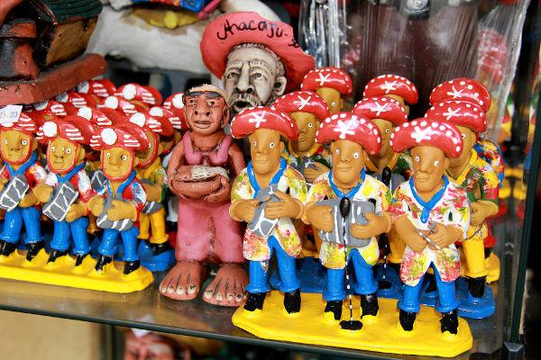
Among the typical celebrations of Sergipe, is the Party of Lambe Sujo and Caboclinhos, which takes place every October and is marked by drama, songs and dances that portray the native populations and Africans who were enslaved in the colonial period. Another local tradition is the fire boat, which became a symbol of June festivities in the municipality of Estância.
Sergipanidade Day is celebrated on October 24th. The date was chosen due to the political emancipation of the territory, which took place in 1820 and was celebrated for the first time on October 24, 1836.
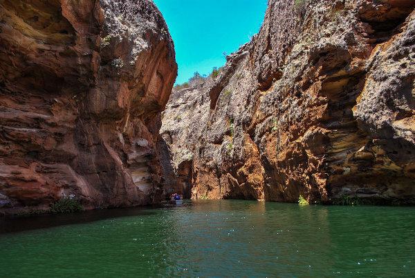
The final stretch of the famous Rota do Cangaço is located in Sergipe, in the municipality of Poço Redondo: Grota do Angico, in Poço Redondo. It is the place where the cangaceiro Lampião and his group were ambushed and killed in 1938.
Read too: Brazilian culture — from diversity to inequality
History of Sergipe
The territory we know today as the state of Sergipe was integrated into the Bahia between 1534 and 1820, forming the then Captaincy of Baía de Todos os Santos.
Although the separation was decreed on July 8, 1820, many consider the date of the political emancipation of the state. as being October 24, 1824, due to several political conflicts that occurred after the dissolution of the captaincy. Furthermore, it was in 1824 that the royal charter with the decree reached Sergipe.
Sergipe was elevated to the status of state in 1889, when it happened to Proclamation of the Republic.
Image credit
[1] Joa Souza / Shutterstock.com
By Paloma Guitarrara
Geography teacher