
You extreme points of Brazill correspond to those localities located on the northern, southern, eastern and western limits of the country. The space between them, which is more than 4 thousand kilometers both from north to south and from east to west, represents the greatest distances that can be covered within the national territory. The identification and demarcation of the extreme points of Brazil is important for the delimitation of the limits of the Brazilian territory, in addition to adding tourist value to the corresponding locations.
Read too: Map of Brazil — the cartographic representation of the country
Summary on the extreme points of Brazil
The extreme points of Brazil are the localities located on the north (source of the Ailã river), south (Arroio Chuí), east (Ponta do Seixas) and west (source of the Moa river) limits of the national territory.
The space between them represents the greatest distances that can be traveled both from north to south and from east to west within the limits of the Brazilian territory.
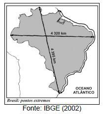
From north to south, this distance is 4,378.41 km, while the east-west measure is 4,326.63 km.
Its demarcation is important for the determination of the territorial limits of Brazil and the consequent establishment of national borders.
What are the extreme points of Brazil?
The extreme points of Brazil are those located in the northern, southern, eastern and western extremities of the national territory. The measured distance between them, from north to south and from east to west, are the greatest possible distances to be measured within the borders of the country. The demarcation of the extreme points of Brazil was made by the Brazilian Institute of Geography and Statistics (IBGE).
Far north: source of the Ailã River |
The northernmost point, that is, the northernmost point of the Brazilian territory, is the source of the Ailã River. It is located in the municipality of Uiramutã, belonging to state of Roraima It's close à border with Guyana. Its coordinates are as follows:
Latitude: 05° 16'19" S
Longitude: 60° 12'45" W
The source of the Ailã River is on Mount Caburaí, which is at an altitude of 1465 meters above sea level. This point was not always considered one of the extremes of Brazil. Mount Caburaí was made official as the extreme north of the country only in 1998, after confirmation made using the Global Positioning System (GPS). Until then, it was said that the Brazilian territory extended from the Oiapoque, the extreme north of the state of amapá, to Chuí, present-day extreme south of Brazil.
Southern end: Arroio Chuí |
The southernmost point of Brazil, or the southernmost, is located in the municipality of Chuí, belonging to state of Rio Grande do Sul, on the border with the Uruguay. It is the Arroio Chuí, a river that acts as a natural border between both countries. According to the IBGE, the coordinates of this point are:
Latitude: 33° 45'07" S
Longitude: 53° 23'50" W
It is important to consider that the point corresponding to the extreme south of Brazil is located on the river bed, and its exact location may undergo periodic variations.
Far east: Ponta do Seixas |
The easternmost point in the national territory, also called the eastern point, is Ponta do Seixas. She stays situated in city of João Pessoa, which is the capital of state of paraíba, in the northeast of the country. Its geographic coordinates are as follows:
Latitude: 07° 09'18" S
Longitude: 34° 47'35" W
Far west: source of the Moa River |
The westernmost or westernmost point of the Brazilian territory is located in the municipality of Mâncio Lima, in the state of acre, on the border with the Peru. It is the source of the river Moa, which is in the Serra de Contamana or Serra do Divisor, at an altitude of 158 meters. Your geographic coordinates are the following:
Latitude: 07° 32'09" S
Longitude: 73° 59'26" W
As we have seen, the distance between the extremes north and south and west and east are the largest found in Brazilian territory. We show below what these measures are:
North-South Distance: 4,378.41 km |
East-West Distance: 4,326.63 km |
See too: Location of Brazil in the world
What is the importance of the extreme points of Brazil?
The demarcation of the extreme points of Brazil is important for the official determination of the territorial limits of the country and therefore the defining your borders. In addition, many of these locations receive physical landmarks that indicate that this is one of the extreme points of the national territory, which can be used as a way of promoting the tourist activity in these areas.
Exercises solved on the extreme points of Brazil
question 1
(UFT) According to the figure, mark the alternative that correctly represents the extreme points of Brazil and their respective locations.
A) To the north, Cape Orange, in Roraima; to the east, the point of Seixas, in Paraíba; to the south, the Arroio Chuí, in Rio Grande do Sul, and to the west, the Serra da Contamana, in Acre.
B) To the north, the Caburaí mountain range, in Roraima; to the east, the point of Seixas, in Paraíba; to the south, the Arroio Chuí, in Rio Grande do Sul, and to the west, the Serra da Contamana, in Acre.
C) To the north, Cape Orange, in Amapá; to the east, the point of Seixas, in Pernambuco; to the south, the Arroio Chuí, in Rio Grande do Sul, and to the west, the Serra da Contamana, in Acre.
D) To the north, the Caburaí mountain range, in Amapá; to the east, the point of Seixas, in Paraíba; to the south, Arroio Chuí, in Rio Grande do Sul, and to the west, the Serra da Contamana, in Amazonas.
Resolution:
Alternative B
The second alternative is the only one that presents the location and correct identification of the extreme points of the Brazilian territory.
question 2
Brazil has more than 8 million km² of territorial extension, being therefore characterized as a country of continental dimensions. Its extreme points are located more than 4 thousand km away in both directions (north-south and east-west), and its delimitation is of great importance, because:
A) attracts greater investment to the municipalities.
B) establishes major national tourist hubs.
C) determines the limits of the territory and assists in the demarcation of borders.
D) renews the geodesic landmarks of the territory.
Resolution:
Alternative C
The greatest importance attributed to extreme points concerns their role in identifying the limits of the national territory and helping to define the country's land borders.
image credit
[1] IBGE (reproduction)
By Paloma Guitarrara
Geography teacher
Source: Brazil School - https://brasilescola.uol.com.br/brasil/pontos-extremos-do-brasil.htm