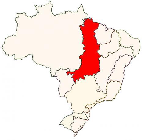
THE rio Tocantins is a Brazilian watercourse that bathes part of the regions Midwest and North of Brazil. It travels 2,416 km from its source, in the state of Goiás, to its mouth, in Marajó Bay, near the capital of Pará. In the region of Bico do Papagaio, it receives the waters of the Araguaia river, thus forming one of the most important hydrographic basins in the country, the Tocantins-Araguaia Basin.
The Tocantins River, in addition to being essential for the direct supply of the local population, for economic activity through fishing, irrigation and tourism, has a high hydraulic potential. Several hydroelectric plants were installed along its course, among them the Tucuruí plant.
Read too: Brazil's hydrographic basins — the drainage network of the Brazilian territory
Overview of the Tocantins River
The Tocantins River is 2416 km long and is the second longest entirely Brazilian river.
It rises in the state of Goiás, from the junction of the rivers das Almas and Maranhão, and crosses the territories of Tocantins and Maranhão until it flows into Marajó Bay, in the north of Pará.
Its main tributary is the Araguaia River, with which it joins at the height of the Bico do Papagaio, in the extreme north of the Tocantins, and gives rise to the Tocantins-Araguaia Hydrographic Basin, the largest basin entirely located in national.
It has great potential for generating Hydro-electric energy, which is why there are several plants installed along its course. The main one is the Tucuruí power plant.
The Tocantins River is also important for supplying the local population, for fishing (commercial or subsistence) and for regional economy, since it has great navigable potential and is a source of water for agricultural crops and other activities economic.
General data of the Tocantins River
Length: 2416 km.
Source: 1100 m altitude.
Main tributaries: Araguaia River, Almas River, Bagagem River, Sono River, Tocantinzinho River, Santa Tereza River, Manoel Alves Grande River and Paranã River.
Mouth: Marajo Bay (PA).
Average flow: 13,600 m³/s.
Maximum flow: 70,000 m³/s.
Basin area: 803,250 km².
-
Parents: Brazil.
States: Goiás, Tocantins, Maranhão and Pará.
Do not stop now... There's more after the ad ;)
Features of the Tocantins River
The Tocantins River is a Brazilian river that rises in the Midwest region of Brazil, in the interior of the Central Plateau. It travels 2416 km in a south-north direction from its source to its mouth, located on the northern coast of Brazil, where it flows into the Atlantic Ocean. Due to its extension, it is considered the second largest entirely Brazilian river, that is, it flows exclusively in the national territory. Just behind the rio San Francisco.
In its course, the Tocantins river bathe a total of four Brazilian states, being them:
Goiás;
Tocantins;
maranhão;
For.
The waters of Tocantins also pass through a set of municipalities in the Midwest, Northeast and North of Brazil, among which are cities such as Colinas do Sul (GO), Porto Nacional (TO), palms, capital of Tocantins, Imperatriz (MA) and Tucuruí (PA). all in all, 29 municipalities are on the path of the Tocantins River. Furthermore, this watercourse crosses two important Brazilian biomes, the thick and the amazon.
In the extreme north of Tocantins, a region known as Bico do Papagaio, the waters of the Tocantins and Araguaia rivers meet. From that point onwards, until its mouth in the state of Pará, the river is commonly referred to as the Tocantins-Araguaia River.
It is a perennial river, whose waters are permanent and flow throughout the year, even during the driest season. Due to the pluviometric regime in the area of its head, it can be said that the Tocantins River is fed mainly by the rains, which are more intense between the months of October to April. The dry season, which is when the lowest rainfall is recorded, occurs from May to September.
Underground water reserves, called aquifers, are also important for the supply of the Tocantins River and its tributaries. One of these aquifers is the Urucuia, which covers part of the north of Minas Gerais and part of the states of Goiás, Tocantins, Maranhão, Piauí and Bahia, being also responsible for part of the flow of the São Francis.
The course of the Tocantins River is divided into three sections:
Upper Tocantins: segment located between its source, which is in Goiás, and the Lajeado waterfall, in Ponte Alta do Tocantins. It consists of the longest stretch, with about 1,000 km long and 925 meters of unevenness.
Middle Tocantins: segment located between the Lajeado waterfall, in the state of Tocantins, and the Itaboca waterfall, in the state of Pará. It has approximately 980 kilometers of extension and 150 meters of unevenness.
Lower Tocantins: final segment of the Tocantins River, entirely located in the state of Pará. The gap is low, only 25 meters, and its total length is about 360 kilometers.
Source of the Tocantins River
As described by the National Water and Sanitation Agency (ANA), the source of the Tocantins River is in the state of Goiás, which integrates the Center-West region of Brazil. It is located between the municipalities of Ouro Verde de Goiás and Petrolina de Goiás, in the central region of the state and north of the capital, goiânia. The Tocantins River is born from the confluence of the Almas and Maranhão rivers, at an altitude of approximately 1100 meters.
Tributaries of the Tocantins River
The main tributaries of the Tocantins River are:
Right bank: Paranã River, Sono River, Tocantinzinho River, Manoel Alves Grande River, Bagagem River, Balsas River and Farinha River.
Left margin: Araguaia River, Santa Tereza River, São José River and Itacaúnas River.
Mouth of the Tocantins River
The mouth of the Tocantins River, which is nothing more than the place where it flows into the Atlantic Ocean, is located in the state of Pará, in the North region of Brazil, in an area known as Baía do Marajó, Golfão Marajoara or even Golfão da Amazônia.
How important is the Tocantins River?
The Tocantins River directly serves a population of almost 8 million inhabitants, a number that tends to increase in the coming years. The Tocantins basin area, in addition, comprises a large agricultural region producing commodities (commodities) such as soybeans, corn and cotton, covering several exporting municipalities and production outlets. In view of this fact, its importance lies both in its socioeconomic, environmental and energy role.
The population that lives on the banks of the Tocantins River has fishing as one of their means of subsistence, serving both for direct food and for generating income for families. The hundreds of species of fish found in the course of the river also attract sport fishing practitioners, making it an attractive region for visitors.
THE tourism is also practiced on the freshwater beaches that appear along the Tocantins River during periods of drought. In economic terms, the use of river waters for irrigation of agricultural crops and in the activity livestock.
Another aspect to be highlighted about the Tocantins River is its navigability, which corresponds to the conditions for carrying out river transport. The river in question has about 1150 km of navigable stretches, which makes it very useful for transporting people and goods on a small scale. The main navigable stretch is in the state of Tocantins, but there is no continuity between the routes. The idea of building a waterway of the Tocantins river has existed for decades, and a series of studies were carried out in the region for the execution of the project.
One of the main characteristics of the Tocantins River is its energy potential, that is, its capacity to generate electricity. The power of the waters of this spring can generate up to 11,500 MW, the third largest power among Brazilian rivers.
In the course of the Tocantins River, there is a set of hydroelectric plants that provide energy to the municipalities and localities in the region and neighboring areas. Among them is the Tucuruí hydroelectric plant, built at the height of the city of the same name in the state of Pará, being the second largest Brazilian plant after Belo Monte, which is in the same state.
Read too: 10 biggest hydroelectric dams in the world
Tocantins-Araguaia Basin
The Tocantins River is the main and largest river in the Tocantins-Araguaia Hydrographic Basin. It is the second largest hydrographic basin in the country and the most extensive located exclusively in Brazil. It covers an area of 86 thousand km² comprising a total of 470 municipalities, which are distributed among the states of Tocantins, Pará, Maranhão, Mato Grosso and Goiás, in addition to the District Federal. Its second main river is the Araguaia River, which flows parallel to the Tocantins River to the Bico do Papagaio, where they meet.
The Tocantins-Araguaia Basin has high hydroelectric power, which is mainly due to the Tocantins River. Is it over there it is also important for the supply of a vast population and for the supply of water to two large brazilian biomes, which are the Cerrado and the Amazon, in addition to its role as a waterway in daily travel.
In addition, the rivers that make up this region are located inside an area known as the agricultural and mineral frontier. of the country and are fundamental for the productive chains that develop there, both in the supply of water and in the transport. To learn more about this basin, read: Tocantins-Araguaia Basin.
Preservation of the Tocantins River
The preservation of the waters of the Tocantins River, as well as its banks and its source, is essential for the maintenance of environmental balance and to guarantee the supply of the population that depends directly on this source, whether for income, food, water itself or even electricity.
In recent years, the removal of riparian vegetation, the damming of extensive areas for the construction of hydroelectric plants and the direct impacts that these large projects imply for the flow of water and the river ecosystem, in addition to residues from economic activities such as The mining and agriculture, have been the main environmental problems observed in the Tocantins River.
Monitoring the use of the waters of the Tocantins River and the elaboration of policies for the preservation of this watercourse are some of the responsibilities of the Secretary of State for the Environment and Water Resources (Semarh) of Tocantins, the state that has the largest extension of the River.
There are ongoing monitoring projects in the Tocantins River, especially in the areas close to the hydroelectric plants, which aim to measure and monitor the quality and composition of the waters, for example. There are also initiatives put into practice through partnerships with local universities, such as the Federal University of Tocantins (UFT), which aim to recover the vegetation cover of springs through the use of seeds of species native.
Some of the projects under execution incorporate the cooperation of civil society, emphasizing the importance of direct involvement of the population and also of environmental education in the protection and preservation of the environment environment.
Check it out on our podcast: Challenges of conserving Brazilian biodiversity
Curiosities about the Tocantins River
The name of the Tocantins River is derived from the Tupi language and was composed of the terms tukan (toucan) and tin (nose), forming the expression Bico do Toucano or Bico do Papagaio. The state of Tocantins was named after the river.
The Tocantins River Basin is the fourth largest in the South America.
The hydroelectric power generation potential of the Tocantins River is the third largest in Brazil. It is behind only the Amazon and Paraná rivers.
Almost 400 species of fish live in the Tocantins River.
Several regional legends and tales are linked to the Tocantins River. One of them is that of the Pirarucu Indian, transformed into a fish by the god Tupã when his body fell into the waters. of this river after being hit by a tree during a hunt he carried out in the midst of a strong storm. Both the storm and the metamorphosis were punishments from Tupã imposed on the indigenous, who, despite his bravery, practiced evil and was a very vain person.|1|.
Grades
|1| ELETROBRAS/ELETRONORTE. Fish from the Tocantins River Basin. Available here. Accessed on 02 Jan. 2022.
By Paloma Guitarrara
Geography teacher