
THE wind rose is a figure that graphically represents the main orientation points on the earth's surface, bringing the indication of cardinal, collateral and sub-collateral points. It was incorporated into maps and also into compass, thus becoming an important instrument for navigation, to indicate the position of an object or person in relation to another and also to move in space.
Read too: World map — the representation of the terrestrial globe on a plane
Summary about the wind rose
The compass rose is the graphical representation of orientation points on the Earth's surface.
It has been incorporated into the compass and is used as a navigation and location instrument.
It also appears on maps as one of its elements.
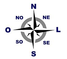
It is composed of four cardinal points (N, S, L, O), four collateral points (NE, SE, NO, SO) and eight subcollateral points (NNE, ENE, ESE, SSE, SSO, OSO, ONO, NNO).
What is the wind rose?
The wind rose is the graphical representation of landmarks that are used for location and orientation
on the earth's surface. These reference points are called Cardinal points and they appear represented in all the figures of compass roses. In some cases, they also bring collateral and sub-collateral points, intermediate positions that offer greater accuracy when finding directions.Also called nautical rose because it is still widely used in objects intended for navigation, it is believed that the origin of the compass rose is associated with the Ancient Greece, as it was justly employed with the aim of determining the direction of the winds.
Its incorporation into portolan charts and maps took place in Middle Ages, from the fourteenth century. At the time, 32 reference points were already identified, which were established from the direction of different winds. There are also reports that the incorporation of the compass rose into compasses took place in the same period, becoming an indispensable object in the period of Great Navigations of the sixteenth century.
Cardinal points
the cardinal points are the main points of reference represented in the compass roses. They are four:
North, represented by the letter No, which always points up. Also called northern or boreal.
South, represented by the letter s and 180° north. It is also called southern or southern.
East, represented by the letter L or AND, from English east. It is in an intermediate position between north and south, positioned on the right. Refers to the east.
West, represented by the letter THE or W, from English west. It is also in an intermediate position between north and south but at 180° east, therefore situated on the left in the compass rose. Refers to the West.
collateral points
the collateral points are intermediate points to the cardinals. There are a total of four points of reference, namely:
North East, represented by the acronym HUH and situated between north and east;
Southeast, represented by the acronym IF (or ES, in English) and situated between east and south;
Northwest, represented by the acronym AT THE (or NW, in English) and situated between north and west;
South-west, represented by the acronym ONLY (or SW, in English) and situated between the south and the west.
subcollateral points
The subcollateral points they are you landmarks located between a cardinal point and a collateral point. In all, there are eight sub-collateral points, which are listed further below.
Like collateral points, they are not represented on all compass roses, but knowing their position is important. important for locating points on a map or even for guiding us more accurately on the earth's surface.
North-Northeast (NNE), situated between the north and northeast;
East-Northeast (ENE), situated between the northeast and the east;
East-Southeast (ESE), situated between the east and the southeast;
South-Southeast (SSE), situated between the southeast and the south;
South-Southwest (SSO), situated between the south and the southwest;
West-Southwest (OSO), situated between the southwest and the west;
West-Northwest (ONO), situated between the west and the northwest;
North-Northwest (NNO), located between northwest and north.
See too:What are geographic coordinates?
Wind rose and Brazil
The study of the compass rose and the knowledge of the points of reference it represents, in addition to being important to guide ourselves, allows us to better understand its correlation with the current Brazil regional division and why each regions receive the name it has.
The current regional division of Brazil was established by the Brazilian Institute of Geography and Statistics (IBGE) in 1970. Although their delimitation was carried out based on social, economic, natural and cultural criteria, all the regionsreceived names according to their position in the Brazilian spatial planning, referring to some of the cardinal points, such as the regions North and South, and collateral, in the case of regions North East and Southeast.
The federation units of Midwest are comprised in part of the center and the western region of the territory. In addition, the Federal District houses, in Planaltina, the central point of Brazil.
Orientation with wind rose and compass

THE compass is a navigation instrument guided by the magnetic needle, which always points to the north. The introduction of this element and therefore the invention of the compass as we know it today was carried out by the Chinese in the 1st century of the current era. However, the incorporation of the wind rose in the base of this instrument is attributed to the Italian Flávio Gioia in the year 1302. Gioia placed a card with a compass rose under the magnetic needle, which made navigation easier.
All compasses we know today have a representation of the compass rose., making it a very important tool for reading maps and identifying the referential position of objects and people on the surface, in addition to helping with displacements. Although technological modernization has culminated in the emergence of more modern methods of positioning, such as satellites and GPS, the compass remains a practical and easily accessible instrument for guiding us across the surface of the planet.
Exercises solved on compass rose
question 1
(PUC-Rio) In a random situation, a person who travels by car from São Paulo to Brasília, from Brasília to Manaus, from Manaus to Belém do Pará and Belém do Pará to Salvador, will follow the path, respectively, in the following directions (based on the cardinal and collateral points, the follow):
a) north; northwest; southeast; North East.
b) north; northwest; North East; southeast.
c) northwest; north; southeast; North East.
d) north; southeast; North East; south-west.
e) northwest; southeast; North East; southeast.
Resolution:
Letter B
Brasília is north of São Paulo, so we can rule out options C and E as an answer. From Brasília to Manaus, the driver will head northwest, which leaves us between A and B. The city of Belém do Pará is located on the coast of Pará, northeast of Manaus. To head towards Salvador, the driver will descend in the southeast direction from Belém to the capital of Bahia. The answer is therefore the letter B. have beside one Brazil's map and the compass rose helps to resolve this issue.
question 2
In the past, the wind rose was used to identify the direction in which the winds were blowing and that's why it got its name. Today, it is an important aid in moving around the earth's surface and in determining absolute and relative positions of a frame of reference, be it a person, a building, a city or even A country. Regarding the aspects and use of this figure, indicate the correct statement:
a) It is composed of the following subcollateral points: northeast, southeast, southwest and northwest.
b) It became obsolete with the advent of new technologies such as GPS.
c) It was incorporated into the compass to facilitate navigation and is now part of that instrument.
d) Indicates only four directions: north, south, east and west.
Resolution:
Letter C
In the 14th century, the compass rose became part of the structure of compasses, which helped with orientation during long-distance travel of the period. Since then, it has become one of the elements of compasses, positioned at its base.
By Paloma Guitarrara
Geography teacher
Source: Brazil School - https://brasilescola.uol.com.br/geografia/rosa-dos-ventos.htm