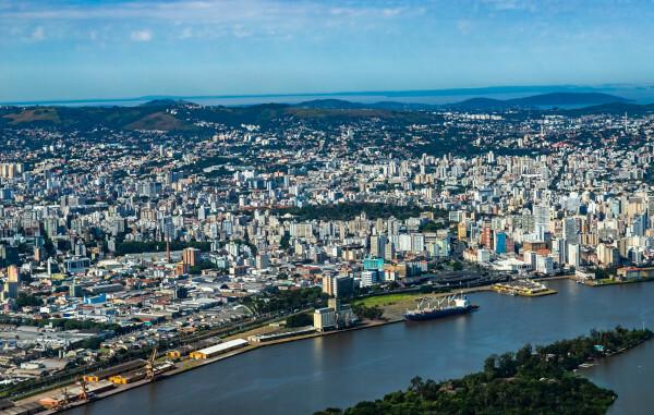
Porto Alegre is the capital of the state of Rio Grande do Sul, which is in the southern region of Brazil. A part of its surface, which is 495 km², is divided into islands surrounded by Lake Guaíba, which has become an important leisure area and tourist attraction in the state capital. The municipality is the most populous in the state and one of the largest in Brazil, currently with 1.48 million inhabitants. The POA Metropolitan Region accounts for 40% of the state's GDP, and the capital's economy is led by the tertiary sector.
Read too: What are the capitals of Brazilian states?
Summary about Porto Alegre
Porto Alegre is the capital of Rio Grande do Sul.
Its foundation took place on March 26, 1772, two decades after the beginning of settlement by the Azoreans.
The city has an area of 495 km², a portion of which corresponds to an archipelago surrounded by the waters of Lake Guaíba.
It forms the Metropolitan Region of Porto Alegre.
It has a subtropical climate and flat terrain surrounded by hills and hills. It is located in a transitory area between the Pampas and the Atlantic Forest.
It is the most populous city in the state and 12th in Brazil, with 1,488,252 inhabitants. In addition, its territory is densely populated, with more than two thousand inhabitants/km².
Porto Alegre's GDP is R$77.13 billion. Its metropolitan region accounts for 40% of Rio Grande do Sul's economy.
Its urban space stands out for the large portion of residences on tree-lined roads.
Among the main tourist attractions in the city are Lake Guaíba and the Usina do Gasômetro.
General data for Porto Alegre
Gentile: Porto Alegre
-
Location
Parents: Brazil
Federative unit: Rio Grande do Sul
Intermediate region[1]: Porto Alegre
Immediate region[1]: Porto Alegre
Metropolitan region: Metropolitan Region of Porto Alegre
- Formed by the municipalities of: Porto Alegre, Alvorada, Cachoeirinha, Campo Bom, Canoas, Estância Velha, Esteio, Gravataí, Guaíba, Novo Hamburgo, São Leopoldo, Sapiranga, Sapucaia do Sul, Viamão, Charqueadas, Araricá, Nova Santa Rita, Montenegro, Taquara, São Jerônimo, Arroio dos Ratos, Santo Antônio da Patrulha, Santana Chapel, Rolante, Igrejinha, São Sebastião do Caí, Dois Irmãos, Eldorado do Sul, Glorinha, Ivoti, Nova Hartz, Parobé, Gate, Triumph.
- Bordering municipalities: Viamão, Alvorada, Cachoeirinha, Canoes, Nova Santa Rita, Triunfo, Eldorado do Sul.
-
geography
- Total area: 495,390 km² (IBGE, 2020)
Total population: 1,488,252 inhabitants (IBGE, 2020)
Density: 2837.53 inhab./km² (IBGE, 2010)
Climate: Subtropical
Altitude: 10 meters
Time zone: GMT -3
-
Historic
Foundation: March 26, 1772
Read too: Curitiba – capital of the state of Paraná and fifth largest Brazilian economy
Porto Alegre geography
Porto Alegre is a Brazilian municipality and capital of the state of Rio Grande do Sul, member of the South region from the country. It extends over an area of 495 km², which is divided between a continuous surface, which represents 91% of the city, and an archipelago, formed by 16 islands surrounded by Lake Guaíba. These islands make up 44 km² of Porto Alegre's territory. In addition to the waters of the Guaíba, the state capital borders seven municipalities:
Canoas and Nova Santa Rita, to the north;
Cachoeirinha and Alvorada, to the northeast and east;
Viamão, to the east and southeast;
Triumph to the northwest;
South Eldorado to the west.
Together with 33 other municipalities, the city is part of the Metropolitan Region of Porto Alegre (RMPA). Next, let us see the main physiographic characteristics of this municipality.
Porto Alegre climate
The predominant climate in Porto Alegre is Subtropical or swet ubtropic. This climate type is characterized by the best distinction between the four seasons. You winters they vary from mild to cold, with an average temperature of 11ºC. You summers they are hot, with temperatures of 25 °C, but which can rise above 30 °C. In addition to the high air humidity, rainfall is well distributed throughout the year, with a short dry interval, totaling 1400 mm per year.
Porto Alegre relief
The city of Porto Alegre is on a flat land, formation that represents approximately one third of its surface. In its surroundings, there is an undulating terrain formed by a set of hills. The highest point in the city is 311 meters above sea level, on Santana hill.
Vegetation of Porto Alegre
Part of the vegetation cover of Porto Alegre integrates the biome Atlantic forest. In 2015, the city was recognized as the capital that most preserves this formation in proportional terms, with 32% of native vegetation. Areas covered with forests, fields, swamps (or swamps), riparian forest and buritizais are found in the municipality.
Porto Alegre Hydrography
Lake Guaíba is one of the main features of the state capital, having importance in several aspects, mainly ecological and economic, especially with regard to tourism in Porto Alegre. The Guaíba area receives water from important rivers in the state, namely: Jacuí, Caí, Sinos and Gravataí.
Porto Alegre map

Porto Alegre Demographics
Porto Alegre is the most populous city in Rio Grande do Sul and the 12th capital with the highest number of inhabitants in Brazil. It currently has a population contingent of 1,488,252 population, according to the estimates of the IBGE. This figure represents 13% of all residents in the state. Furthermore, the city has 33.8% of the population of its Metropolitan Region, which currently has 4.4 million inhabitants.
In addition to being populous, Porto Alegre is a densely populated city. THE demographic density in 2010, according to data from the last Census, it was 2837.53 inhab./km², the second largest in Rio Grande do Sul and 40th on a national scale. Taking into account your household condition, the IBGE points out that all residents of the state capital live in its urban area.
The population of Porto Alegre is composed of 79.23% of self-declared white people, 10.21% black, 10.03% brown, and approximately 0.62% between yellow and indigenous (0.29% and 0.23%, respectively). The composition by age has changed in recent years, with the growth in the number of elderly people and the drop in the fertility rate, thus characterizing a process of population-ageing. Check out the discussion of this important concept of demographic studies in our podcast: ANDpopulation aging and economy.
Porto Alegre geographic division
According to 2016 legislation, the city of Porto Alegre is made up of 94 official neighborhoods. The subdivision of neighborhoods takes place in two different ways. The first is based on the Management and Planning Regions (RGP), numbered from 1 to 8. The second is based on the Participatory Budget Regions (ROP), which currently comprise 17 areas made up of different neighborhoods.
Porto Alegre Economy
Porto Alegre emerges as the biggest economy in Rio Grande do Sul and the seventh richest city in the country. Your Gross Domestic Product (GDP), according to the IBGE (2018), is of R$ 77.13 billion, which corresponds to approximately 16.8% of the GDP of Rio Grande do Sul. The metropolitan region of Porto Alegre concentrates the main economic and industrial activities in the state, representing a share of more than 40% of the state's economy.
The activities of the tertiary sector are predominant when analyzing the economic profile of Porto Alegre. With the exception of public administration, this segment accounts for 80.79% of the value added to the municipal GDP. The role of business and leisure tourism stands out, as well as the intense commercial activity of the capital.
O secondary accounts for 8.33% of the value added to GDP, which is derived from a very diverse industrial park. It comprises industries in the chemical and petrochemical, metal-mechanical, tobacco, food and beverage, textile, furniture, transport equipment, and paper and cellulose industries.
Agriculture is responsible for only 0.04% of Porto Alegre's GDP. Among the crops developed in the state capital are rice, soybeans, cassava, sweet potatoes and peaches. In livestock raising, sheep, chicken and their cattle herd are important.
Porto Alegre Government
The Porto Alegre government is of the representative democratic type. The population of the state capital is the one who elects its governors, and this process takes place at intervals of four years. O boss of FOROder ANDmunicipal executive is the Mayor. The Legislative, in turn, is represented through the City Council, which is composed of 36 councilors.
The municipality of Porto Alegre, as the state capital, is home to the seat of government of the state of Rio Grande do Sul, located at Palácio Piratini. This means that the city is its political center, and in it the main administrative orders and activities of the state sphere are carried out.
Porto Alegre Infrastructure
With their homes located in an urban area, it can be said that Porto Alegre offers a wide network of urban infrastructure. According to IBGE data for 2010 and compiled by the POA Observatory, 82.7% of homes were located in wooded areas, a good rate when compared to several other cities.
Most households were on paved roads and with sidewalks, respectively 87.9% and 77%. Adequate sanitary sewage covered 93% of the homes in the state capital, while the water and electricity networks covered more than 99%.
Displacements in the city are made by different modes, notably through the municipal buses, which have 65 km of exclusive corridors (according to 2017 data), and also the urban train lines. O waterway transport is used for connecting to neighboring cities, such as Guaíba, in addition, of course, to the highways that connect the state capital with other states and regions. The largest and main airport in Rio Grande do Sul is located in its capital, Porto Alegre International Airport – Salgado Filho.
Porto Alegre Culture
The Porto Alegre culture received a lot influence of migrants who moved to cities in Rio Grande do Sul, with a large presence of Azoreans, Germans, Italians and Africans.
The city has in its calendar a series of parties and celebrations that bring together people from all over the capital and Rio Grande do Sul, such as the Fthese Junited, the Farroupilha Week and also the Festa de Navegantes, of a religious nature, held in February. Comic fairs, craft fairs, the traditional book fair attract people from different areas of the country. Another highlight was the Mercosul Biennial, an international art exhibition held in the state capital.
Porto Alegre also has various meeting places and sights. One of the most famous is Lake Guaíba, where people gather for leisure and enjoy the natural landscape. The Usina do Gasômetro is located in this area, a historic building that has also become one of the main points of visitation in the state capital. The Historic Center is where cultural centers are concentrated, museums, libraries and historic buildings, which recount the formation of Porto Alegre.
![Usina do Gasômetro, in Porto Alegre (RS).[1]](/f/bf3014150ffed4ce364b70fb1a4b7f17.jpg)
history of Porto Alegre
The city of Porto Alegre started from the migration of the Azoreans, in the year 1752, which established themselves in the region as a result of the agreements signed by the Madrid Treaty. The settlement received initially the name of Porto de Viamão. Two decades later, on March 26, 1772, the city was founded under the name of Parish of São Francisco do Porto dos Casais, which became Nossa Senhora da Madre de Deus of Porto Alegre, in 1773. In that same year, Porto Alegre was elevated to the status of capital of the captaincy that would come to be called the captaincy of São Pedro do Rio Grande a few years later.
the intense migratory flow that arrived in Brazil in the 19th century it was also directed to the capital of Rio Grande do Sul, which received immigrants:
germans
italians
Africans
Spanish
Lebanese
Jews
Polish
This same period is marked by the conflict known as War of the Ragsor Ragamuffin Revolution, which meant the stagnation in the process of urban development in Porto Alegre between 1835 and 1845. From the end of the conflict, and especially in the first decades of the 20th century, the city experienced an intense cycle of growth. Today, Porto Alegre emerges as the largest municipality in the state.
Image credit
[1] JR Moreira / Shutterstock
By Paloma Guitarrara
geography teacher