
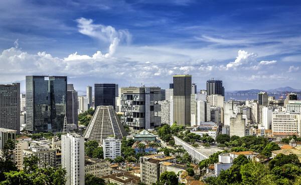
Rio de Janeiro is a Brazilian city and capital of the state of the same name., located on the southeast coast. It is the second largest city in the country, with more than 6.7 million inhabitants. one of the main economies in the national territory. The activities of the tertiary sector lead the Rio economy, with great emphasis on tourism, since Rio de Janeiro is one of the main tourist destinations in Brazil.
Read too: What are the capitals of Brazilian states?
Summary about the city of Rio de Janeiro
It is a Brazilian city and capital of the state of the same name.
It played the role of capital of Brazil between 1763 and 1960.
It is considered a global city.
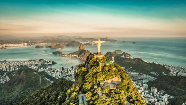
It has a humid tropical climate and relief formed by plains, mountains and hills. One of its characteristic features is the Sugarloaf Mountain.
It has 6,747,815 inhabitants, making it the second most populous city in Brazil.
With a GDP of R$ 364 billion, it is the second largest municipal economy in the country. The tertiary sector is the main segment, with an emphasis on tourism.
It houses the headquarters of important national and multinational companies, such as Petrobras.
Its urban landscape is considered a World Heritage Site by UNESCO.
General data for the city of Rio de Janeiro
Gentile: From Rio
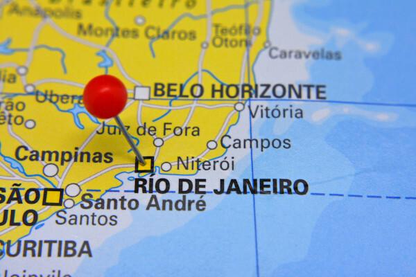
Location: Southeast
Parents: Brazil
Federative unit: Rio de Janeiro
Intermediate region[1]: Rio de Janeiro
Immediate region[1]: Rio de Janeiro
-
Metropolitan region: Metropolitan Region of Rio de Janeiro
Formed by the following municipalities: Rio de Janeiro, Belford Roxo, Duque de Caxias, Guapimirim, Itaboraí, Itaguaí, Japerí, Magé, Maricá, Mesquita, Nilópolis, Niterói, Nova Iguaçu, Paracambi, Petrópolis, Queimados, Seropédica, São Gonçalo, São João de Merití, Tanguá, Macacu and Rio waterfalls Beautiful.
Bordering municipalities: Itaguaí, Nova Iguaçu, Nilópolis, São João de Meriti, Duque de Caxias, Mesquita.
→ geography
Total area: 1200.329 km² (IBGE, 2020)
Total population: 6,747,815 inhabitants (IBGE, 2020)
Density: 5265.82 inhab./km² (IBGE, 2010)
Climate: wet tropical
Altitude: two meters
Time zone: GMT -3
→ Historic
Foundation: March 1, 1565
See too: Vitória – capital of Espírito Santo and is divided into a continental and an insular part
Geography of the city of Rio de Janeiro
Rio de Janeiro is a Brazilian city, capital of the state of the same name that integrates the rSoutheast region from the country. It extends over an area of approximately 1200 km², according to IBGE data for 2020. Its coastline of 246.22 km is divided in three different sectors:
O Atlantic Ocean;
Guanabara Bay to the northeast;
the bay of Sepetiba to the west.
Furthermore, the coast of Rio de Janeiro is formed by about 37 km² of islands, which are mainly concentrated in Guanabara Bay.
Along with 21 other municipalities in Rio de Janeiro, it forms the Metropolitan Region of Rio de Janeiro, the second largest in Brazil. In addition, the city is part of the megalopolis that encompasses greater São Paulo, Sorocaba, municipalities in the Baixada Santista, Paraíba valley and the interior of São Paulo, such as Campinas. Let's check out the main physical characteristics of the city also known as the Marvelous City.
Weather in the city of Rio de Janeiro
The climate of Rio de Janeiro is the Ttropical wet, characterized by summers hot and rainy and winters mild and dry. The average annual temperature is around 22 ºC. In summer, thermometers can read 30°C and winters record averages of 18°C. The annual rainfall index varies between 1200 mm and 1800 mm.
Relief of the city of Rio de Janeiro
The lands that make up the city of Rio de Janeiro are part of the domain of smiss of the sea, which extends along the southeast coast of Brazil and a part of the south. Thus, the hills and mountains are quite common in the Rio landscape, as well as the plains that form the lowest and least rugged areas.
The Pedra Branca peak is the highest point in Rio de Janeiro, located 1025 meters above sea level. Its most famous landscape and postcard of the city, the Sugarloaf and Urca hills are formed by granitic and gneissic rocks shaped by erosive agents.

Vegetation in the city of Rio de Janeiro
The city integrates the biome Atlantic forest. Rio de Janeiro is home to one of the largest urban forests in the world, the Tijuca forest, located in the Parque Nacional da Tijuca, currently an important conservation unit that houses thousands of plant species and hundreds of species animals.
Rio de Janeiro hydrography
The main watercourse in the city is the Guandu, responsible for its supply. Also noteworthy are the Cabuçu or Piraquê, Carioca and Cachoeira rivers. The surface waters of Rio de Janeiro also include lakes such as Jacarepaguá, Marapendi, Lagoinha and Rodrigo de Freitas.
Rio de Janeiro city map
Demographics of the city of Rio de Janeiro
The city of Rio de Janeiro is the second most populous in Brazil, with 6,747,815 inhabitants, according to the IBGE. This value corresponds to 38.8% of the entire population of the state of Rio de Janeiro and about half of the residents of its metropolitan region, which adds up to more than 13 million people. The capital of Rio de Janeiro is also a very populated city., which means it has high demographic density. In 2010, the population distribution was 5265.82 inhab./km², the fourth largest in the state.
The latest IBGE Census indicates that all residents of Rio de Janeiro live in the urban area of the city. It is noteworthy, however, that a considerable amount of the population of Rio lives on the outskirts of the city, more specifically in the shanty towns. The 2010 survey shows that approximately 1.39 million Cariocas lived in 763 favelas, thus making up 22% of the capital's residents at the time. The most populous of them is the community of Rocinha, with 69 thousand inhabitants.
Check out our podcast: Slums and Segregation
Geographical division of the city of Rio de Janeiro
The city of Rio de Janeiro is currently composed of 163 neighborhoods. These are divided into 33 Administrative Regions (RA), which are part of the so-called planning regions, which are distributed over five different areas.
Economy of the city of Rio de Janeiro
The city of Rio de Janeiro has the second biggest Gross Domestic Product (GDP) municipal of Brazil. According to IBGE data for 2018, the value reached R$ 364 billion, which is equivalent to approximately 5.2% of all the wealth generated in the country and half of the economy of the state of Rio de Janeiro. Following the trend of other large urban centers, it's the tertiary sector that leads the Rio economy. Disregarding public administration activities, the segment accounts for 68% of the municipality's GDP.
Rio de Janeiro is home to the headquarters of large and important Brazilian companies (public and private) and international belonging to a wide variety of sectors, with emphasis on oil and extractives, such as Petrobras and Vale S.A. Thus, it can be said that the city is the economic and financial center of the state and one of the main ones in the country, housing, also, the headquarters of important national institutes and public entities, such as the National Development Bank (BNDES) and the IBGE.
Tourism has great weight in Rio's economy, being the city one of the main tourist destinations in Brazil and in the world. Holding large events, such as the 2016 Olympics and the 2014 World Cup, Çarnaval and music festivals such as Rock in Rio help further leverage the already busy industry.
Rio de Janeiro City Government
The government of the city of Rio de Janeiro is of the participatory democratic type. Cariocas go to the polls every four years to elect the politicians who will occupy the main positions in the municipality. O Mayor is the head of FOROder ANDexecutive, while the City Council, the representative body of the Legislative Power, has 51 councilors.
The administration of the capital of Rio de Janeiro is also divided by the sub-prefectures, currently numbering eight. Its highest authority is the deputy mayor, also a member of the executive branch. The occupant of the position, however, is appointed by the mayor of the municipality.
Rio de Janeiro, as the capital, is home to the seat of government of the state of the same name. Its main activities and representatives are concentrated in the Guanabara Palace.
Infrastructure of the city of Rio de Janeiro
The last IBGE Census, carried out in 2010, indicated that the entire population of Rio lives in the urban area of the municipality, which means that there is an urban infrastructure network to meet the basic needs of its residents. The same research showed that 90.4% of Rio homes havein access to the sanitation network adequate, with garbage collection serving almost all of them.
The municipal water supply network was then connected to 98.4% of households, and electricity reached 99.9%. It should be noted, however, that in some of the favelas in Rio de Janeiro, problems in accessing one or more of these services are identified.
The displacements in the capital of Rio de Janeiro are made through different modes. Cable cars were part of the routine of many residents of the communities, but most of them are now stopped. The Corcovado cable car is widely used by tourists visiting the city.
In addition, Rio has subway and tram lines, but buses are the main means of public transport in the city. The main airports in the state are in its capital, which are Santos Drummont and Tom Jobim (Galeão), with an emphasis also on the port of Rio de Janeiro.
Culture of the city of Rio de Janeiro
The city of Rio de Janeiro was recognized by UNESCO as World Heritage for its Urban Cultural Landscape, in the year 2012. The urban space in Rio de Janeiro has many elements and features that recount the city's history from its foundation to the contemporary period, with emphasis on the structures conceived from the start of the arrival of the portuguese royal family, at the beginning of the 19th century.
Rio presents a very intense cultural life, with numerous theaters, such as the Municipal Theater of Rio de Janeiro, cinemas, libraries and museums, with emphasis on the Museum of Tomorrow and the National History Museum.
Among the typical manifestations of the city are the songs and dances characteristic of the carioca people, as well as parties held annually that attract thousands of tourists to the city of Rio de Janeiro, such as Carnival and the traditional New Year's Eve on the beach. Furthermore, Rio de Janeiro is an important center for television and film productions from the country.
History of the city of Rio de Janeiro
The Portuguese made the first contact with the area where today Rio de Janeiro is located right in the beginning of the process of colonization of Brazil, already giving it the name by which we know it today because they confused the bay with the mouth of a river. These events took place in January, and hence the composition of Rio de Janeiro. Before the Portuguese finally arrived in the region, the lands were occupied by other foreign peoples: the French.
The Portuguese colonizers turned their attention to Rio in the year 1530, managing to expel the French only 30 years later, in 1560. The city's development began with the current Praça Quinze, which at the time was called Morro do São Januário.
The development of the gold economy in the Southeast region of Brazil and the strategic position of Rio de Janeiro made the capital of the country was transferred from Salvador (BA) to the municipality, which played this role from 1763 until the inauguration of Brasília in 1960. Thus, Rio was capital of Brazil while çoland, iempire and part of rpublic.
Another landmark event of great relevance to the city's urban development was the transfer of the royal family from Portugal to Brazil, arriving in Rio de Janeiro in 1808. The city underwent an intense landscape reform in the 20th century, and today it is one of the main tourist destinations in Brazil, in addition to being its second largest city.
By Paloma Guitarrara
geography teacher
Source: Brazil School - https://brasilescola.uol.com.br/brasil/cidade-do-rio-de-janeiro.htm