O world map, also known as the planisphere, is nothing more than the representation of the terrestrial globe in a plane. It has various functions that range from calculating distances to studying different aspects of the earth's surface.
In general, represents the disposition of different countries, continents and oceans. Its production is based on different cartographic projections.
Read too: Map of Brazil - cartographic representation of the Brazilian territory

To download the PDF image, Click here!
World map function
THE making and using a world map can serve several purposes, which may appear directly expressed in some of the planisphere elements (title and caption) or vary according to the reader's intention.
One of its main functions is the identification and spatial location of countries as well as the recognition of their territorial limits and borders. Likewise, it is used to identify continents, hemispheres, and seas and oceans.
Considering the history of cartography and the making of the first world maps, it serves:
- navigation and spatial orientation in general;
- for performing distance calculations between different points;
- for calculations related to the planet's time zones.
When it's about thematic letters, the function of the map can still be the study, on a world scale:
- of physical aspects (relief, which sometimes includes oceans, climate zones, vegetation);
- of the political division;
- population distribution and other criteria selected at the time of making the map.
Do not stop now... There's more after the advertising ;)
continents of the world
The emerging lands of the planet are subdivided into six continents:
- Africa
- America
- Antarctica
- Asia
- Europe
- Oceania
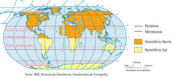
Its spatial distribution can be seen in the map below, produced by the Brazilian Institute of Geography and Statistics (IBGE).

THE Africa is the continent that brings together the largest number of countries, 54. Its territorial extension is just over 30 million km2 or 20% of the surface surface of planet Earth, being the second largest.
O largest continent in territorial extension is the Asia, with 44.46 million km2 (29.85% of the total) and 49 countries.
THEAmerica can be subdivided into three: North America, Central America and South America. Altogether, they bring together 35 countries in a total area of 42.29 million km2 (28,39%).
THE Europe has 49 countries and 9.94 million km2, which is equivalent to 6.67% of the emerged lands.
THEOceania totals 7.6 million km2 (5.1% of the total) and brings together 14 countries.
Lastly we have the AntarcticadThe, with 14.2 million km2 (9.53%), not constituting a country nor being an integral part of any other territory.
See too: How does remote sensing work?
Countries of the world
The world currently has 193 countries. This number is in accordance with the total number of member countries of the United Nations Organization. Some sources report a total of 195 countries, including the Vatican it's the Palestinian State.
In the following tables we present all the countries, separated by the continent of which they belong.
African countries
South Africa |
Eritrea |
mali |
Senegal |
Angola |
Ethiopia |
Morocco |
Sierra Leone |
Algeria |
Swatini |
Mauritania |
seychelles |
benin |
Gabon |
Mozambique |
Somalia |
Botswana |
Gambia |
Namibia |
Sudan |
Burkina Faso |
Ghana |
Niger |
Southern Sudan |
Burundi |
guinea |
Nigeria |
Tanzania |
Cape Green |
Guinea Bissau |
Kenya |
Togo |
Cameroon |
Equatorial Guinea |
Central African Republic |
Tunisia |
Chad |
Lesotho |
Democratic Republic of Congo |
Uganda |
Comoros |
Liberia |
Congo Republic |
Zambia |
Costa do Marfim |
Libya |
Republic of Mauritius |
Zimbabwe |
Djibouti |
Madagascar |
Rwanda |
|
Egypt* |
Malawi |
Sao Tome and Principe |
*Country whose territory extends over more than one continent.
countries of america
The countries are separated by blocks:
- North America, in yellow;
- Central America, in red;
- South America, in blue.
Canada |
Dominica |
Saint Lucia |
Ecuador |
U.S |
El Salvador |
Saint Kitts and Nevis |
Guyana |
Mexico |
Grenade |
Saint Vincent and the Grenadines |
French Guiana |
Antigua and Barbuda |
Guatemala |
Trinidad and Tobago |
Paraguay |
Bahamas |
Haiti |
Argentina |
Peru |
Barbados |
Honduras |
Bolivia |
Suriname |
Belize |
Jamaica |
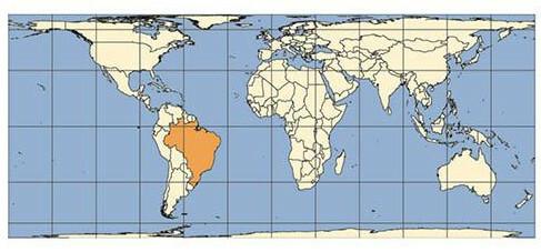
Brazil |
Uruguay |
Costa Rica |
Nicaragua |
Chile |
Venezuela |
Cuba |
Dominican Republic |
Colombia |
Asian countries
Afghanistan |
Singapore |
Japan |
Russia* |
Saudi Arabia |
North Korea |
Jordan |
Syria |
Armenia* |
South Korea |
Kuwait |
Sri Lanka |
Azerbaijan* |
Egypt* |
Laos |
Tajikistan |
Bahrain |
UAE |
Lebanon |
Thailand |
Bangladesh |
Philippines |
Malaysia |
East Timor* |
Brunei |
Georgia* |
Maldives |
Turkmenistan |
Bhutan |
Yemen |
Myanmar |
Turkey* |
Cambodia |
India |
Mongolia |
Uzbekistan |
Kazakhstan* |
Indonesia* |
Nepal |
Vietnam |
Qatar |
Will |
Oman |
|
China |
Iraq |
Pakistan |
|
Cyprus* |
Israel |
Kyrgyzstan |
*Countries whose territories extend over more than one continent.
O State of Palestine belongs to the Asian continent.
European countries
Albania |
Slovakia |
latvia |
Portugal |
Germany |
Slovenia |
Liechtenstein |
Czech republic |
Andorra |
Spain |
Lithuania |
Romania |
Austria |
Estonia |
Luxembourg |
Russia* |
Belgium |
Finland |
Northern Macedonia |
San Marino |
Belarus |
France |
Malta |
Serbia |
Bosnia Herzegovina |
Greece |
Moldavia |
Sweden |
Bulgaria |
Hungary |
monaco |
Switzerland |
Kazakhstan* |
England (United Kingdom) |
Montenegro |
Turkey* |
Cyprus* |
Ireland |
Norway |
Ukraine |
Croatia |
Northern Ireland (United Kingdom) |
Netherlands |
Vatican** |
Denmark |
Iceland |
Wales (United Kingdom) |
|
Scotland (United Kingdom) |
Italy |
Poland |
*Countries whose territories extend over more than one continent.
**The Vatican integrates Europe, being located in the Italian capital, Rome.
Oceania countries
Australia |
Solomon Islands |
palau |
Tuvalu |
Federated States of Micronesia |
Kiribati |
Papua New Guinea |
Vanuatu |
fiji |
Nauru |
Samoa |
|
Marshall Islands |
New Zealand |
tonga |
Also access: The 10 poorest countries in the world
Seas and oceans of the world
The surface of the water covering the Earth it has a length of 361,132,000 km2, which is equivalent to 70.8% of the entire surface area of the planet. splits into big five oceans:
- Atlantic
- Pacific
- Indian Ocean
- arctic glacier
- Antarctic Glacier
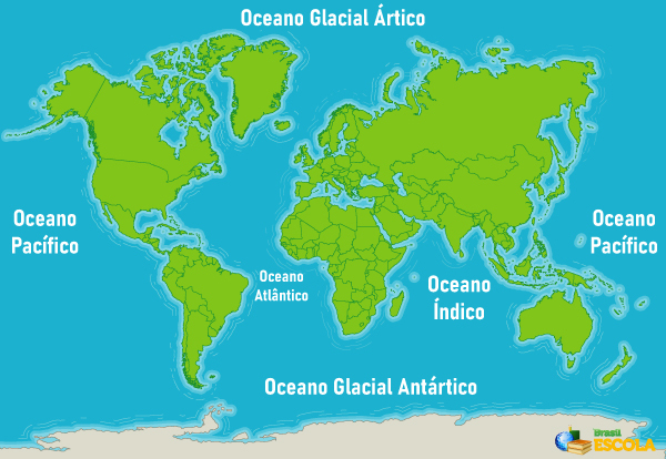
O Pacific ocean is the largest in extension (155.55 million km2) and bathes the west coast of South, Central and North America, as well as eastern Asia and Oceania and Antarctica. It can be divided into North Pacific and South Pacific.
O Atlantic ocean is 76.76 million km2 and bathes the east coasts of the Americas and the west of the African and European continents. It is divided into North Atlantic and South Atlantic.
O Indian Ocean has 68.55 million km2 surface area and completely bathes Oceania, the western portion of Africa and a portion of Asia.
O arctic glacial ocean it bathes the northern end of the continents located in the Northern Hemisphere and has just over 14 million km2 of area. O antarctic glacial ocean, located in the Southern Hemisphere, bathes the homonymous continent and has an area of 20 million km2. These oceans do not always appear broken down, as their classification is not unanimous. It is common to find only the three oceans described above as the main bodies of water on the planet.
There are also large masses of salt water in contact with the continental surface and that correspond to extensions or part of the oceans, receiving the denomination of seas. Considering their surface area, some of the largest seas on the planet are:
- Red Sea, located between the African and Asian continents, in a gulf that connects to the Indian Ocean.
- China Sea (or South China Sea), located south of China and connecting to the Pacific Ocean.
- Caribbean Sea in Central America, connected to the Atlantic Ocean.
- Bering Sea, located in the Pacific Ocean, between Asia and North America, more specifically between Siberia and Alaska.
- Mediterranean Sea, located between Europe and Africa and connecting to the Atlantic Ocean to the east and Asia to the west.
Imaginary Lines of the World Map
The world map is divided by imaginary perpendicular horizontal (or latitudinal) and vertical (or longitudinal) imaginary lines - called, respectively, parallels and meridians.

The Earth has five parallels which receive special names and have specific attributions, in addition to helping to define the geographic coordinates and location of a point on the surface. Are they:
- equator line: parallel of 0° that divides the Earth into Northern Hemisphere and Southern Hemisphere. Above and below it, the counting of parallels is made in an increasing way until reaching 90º at the poles.
- Tropic of Cancer: 23º27’ parallel located in the Northern Hemisphere, crossing 19 countries.
- Tropic of Capricorn: 23º27’ parallel located in the Southern Hemisphere, crossing 10 countries.
- Arctic Circle: 66º33’ North parallel crossing eight countries.
- Antarctic Polar Circle: 66º33’ south parallel that circles Antarctica.
You meridians correspond to vertical lines drawn on the globe, which are used to mark the longitude, whose values range from 0º to 180º west and east. O Greenwich Mean Time represents the 0º longitude and separates the world between the two hemispheres, western and eastern; it is also used as the zero point of the time zone count.
World map representations
The world map or planisphere can be represented based on different cartographic projections.
As a result of the difficulty transposing a spherical surface to a plane, there are distortions of surface aspects in all projection systems, namely the size or shape of territories, location and positioning of continents, among others. The type of distortion will depend on the surface used (conical, cylindrical or spherical).
Read too: What is the shape of the Earth?
Mercator projection
THE Mercator projection it is of the cylindrical type and has parallels and meridians forming right angles to each other. The map resulting from its application ends up centralizing the European continent and distorting the territories located in higher latitudes.
Galls-Peters Projection
Also known as Peters projection, consists of a equivalent cylindrical type projection. This means that there is no distortion of the size of territories, contrary to their shapes.
This projection highlights developing countries, which appear elongated and centralized, unlike developed countries.
azimuth projection
The maps made based on the azimuthal projection appear in the circular shape, in which the parallels form concentric circles cut by meridians that converge at the central point.
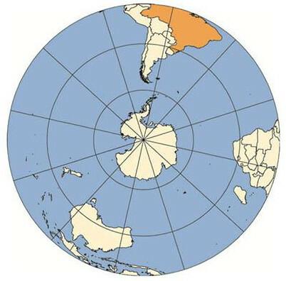
In this type of projection, a flat surface tangent to the curvature of the globe in the area to be represented, in the case of the previous example, the South Pole of the Earth. Distortions increase as you move away from the center point.
Robinson's projection
Robinson's projection is the one that presents the fewer distortions in the final product, both in the area of the territories and in their form. Parallels are represented in straight lines, while meridians appear curved. It is the most used projection for the production of world maps.

Read too: Mollweide projection - correct representation of the central areas and distorted at the ends
solved exercises
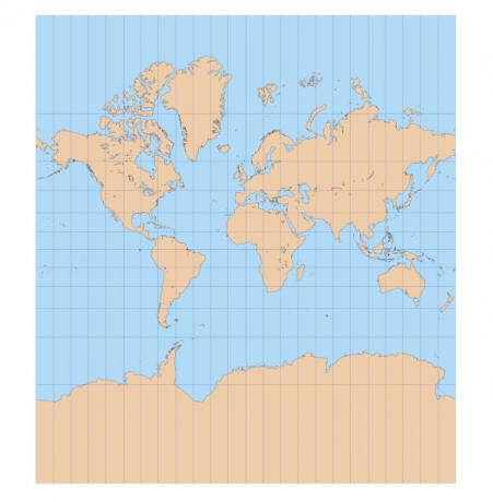
Question 1 – (Unicamp) A world map in the Mercator projection is reproduced below.

It is possible to say that in this projection:
A) the meridians and parallels do not intersect at 90° angles, which promotes an increase in continental masses at high latitudes.
B) the meridians and parallels intersect at 90° angles, which distorts the terrestrial portions close to the poles more and less the portions close to the equator.
C) there are no distortions in the continental masses and oceans at any latitude, allowing the use of this map for maritime navigation up to the present day.
D) the meridians and parallels intersect at perfect 90° angles, which makes it possible to represent the Earth without deformations.
Resolution
Alternative B. The projection in question deforms the surfaces at higher latitudes and, therefore, farther from the Equator and closer to the poles.
Question 2 – (Unesp 2018)
1. It is the angular value of the meridian arc between the equator and the parallel of the reference place. It will always be north or south.
2. It is the angular value, along the Earth's axis, of the plane formed by the extension of the ends of the arc included between the Greenwich Meridian and the arc of the place of reference, considering this plane always parallel to the plane of Ecuador. It will always be east or west.
(Paul A. Duarte. Basics of cartography, 2008. Adapted.)
In the excerpt, 1 and 2 correspond, respectively, to
A) longitude and latitude.
B) latitude and longitude.
C) longitude and meridian.
D) tropic and parallel.
E) latitude and parallel.
Resolution
Alternative B. Section number 1 refers to latitude, while section number 2 describes longitude.
By Paloma Guitarrara
geography teacher