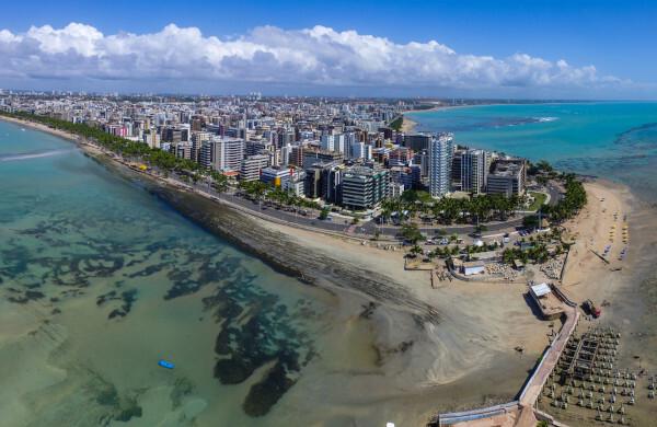
Maceio is a Brazilian city located on the coast of Northeast region from the country. It is located in the state of alagoas and houses the seat of the state government. With an outlet to the Atlantic Ocean, the city is characterized by its relief that varies from flat to wavy and by its humid tropical climate, with a dry season, which is the summer.
They play an important economic role in the state, with emphasis on tourism, the chemical and petrochemical industry and sugarcane cultivation. The capital of Alagoas is densely populated and heavily populated, with more than one million inhabitants.
Read too: Brasília – Federal Capital of Brazil
General data for Maceio
Gentile: Macedonian
Location:
- Parents: Brazil
- Federative unit: alagoas
- Intermediate region: Maceio
- Immediate region: Maceio
- Metropolitan region: 12 municipalities
- Bordering municipalities: São Luís do Quitunde, Barra do Santo Antônio, Paripueira, Coqueiro Seco, Santa Luzia do Norte, Satuba, Rio Largo, Messias, Flexeiras.
Geography of Maceio
- Total area: 509.34 km² (IBGE, 2020)
- Total population: 1,025,360 inhabitants (IBGE, 2020)
- Density: 1,854.10 inhab./km² (IBGE, 2010)
- Climate: wet tropical
- Altitude: 16 meters
- Time zone: GMT -3
Historic
- Foundation: December 5, 1815
Geography of Maceio
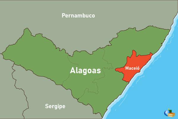
The Brazilian city of Maceió is in the state of Alagoas, in the Northeast region of the country. It plays the role of state capital, thus housing the seat of government. The territory of Macao is located on the coastal strip, in the Zona da Mata sub-region. It has an area of 509.32 km², making it the 10th largest municipality in Alagoas and the 18th Brazilian capital in this regard.
O IBGE classifies Maceio as a regional capital, according to its region of influence. With another 11 municipalities, listed below, it forms the Metropolitan Region of Maceió.
watchtower
Barra do Santo Antônio
Barra de São Miguel
Dry coconut
marshal deodoro
Messiah
Paripueira
cornerstone
Rio Largo
Satuba
Santa Luzia do Norte
Let's see, next, the main physical characteristics of Maceió.
Maceio climate
Maceió is a coastal municipality located between the latitudes of 9º S and 10º S, having, therefore, the maritime nature and the (low) latitude as the main climate factors. The occurrence of the climate is predominant Twet tropical.
It is characterized by high temperature and humidity for most of the year, with maximums reaching almost 30°C and averages around 25°C. O summer it is the driest season of the year, with an increase in rainfall in the months corresponding to the autumn and to Winter.
See too: Is the Northeast just dry?
Maceio relief
The land on which the city of Maceió is located belongs to the domain of plains and coastal lowlands, according to the classification of Aziz Ab’Sáber. Thus, almost all of its territory has relief that ranges from flat to wavy, marked by the presence of coastal tablelands. Throughout its coastal strip and in the south and southwest of the state, plains and beaches predominate. The city is situated at an altitude of 16 meters above sea level.

Vegetation of Maceio
Maceió is part of the biome of Atlantic forest, being part of its native vegetation cover characteristic of this domain. Predominantly grass and shrub species are found, as well as formations characteristic of coastal wetlands, such as mangroves and restingas.
Maceio hydrography
Located on the coast of Alagoas, Maceió has an outlet, to the east, to the Atlantic Ocean. The main watercourse responsible for supplying the state capital is the river Pratagy.
it is observed the presence of ponds in the Maceio landscape, among which the Mundaú lagoon stands out. It covers an area of about 27 km², where a archipelago fluviomarinho called Nove Ilhas, a place with high tourist value for the region. The islands that make up this set are as follows:
of the swallows
of Irenaeus
Of fire
of Santa Marta
of the admiral
of a single coconut tree
of the Goats
of Santa Rita
let's go
Map of Maceio

Demographics of Maceió
the municipality of Maceió is the most populous in Alagoas, currently with 1,025,360 inhabitants. This value is equivalent to 30.5% of the entire state population, ranking 14th among Brazilian capitals. With a restricted area, Maceió is a highly populated city, that is, with a high population concentration, which is around 1,854.10 inhabitants/km², according to data from the 2010 IBGE Census.
A large part of the population of the capital of Alagoas is concentrated in the age groups that are between 10 and 39 years old, which characterizes a young population.
Concerning color or race, the Census points out that:
54.35% of Maceioans declare themselves brown;
36.75%, white;
7.47%, black;
1.17%, yellow;
0.26%, indigenous.
The IBGE survey also shows that more than 62% of the population of Maceió professes the Catholic faith, 23% are Evangelicals, and the remaining group declares themselves to be Spiritists.
Read too: What is population density?
Geographical division of Maceio
The territory of Macao is divided into 53 districts, which, in turn, make up the so-called administrative regions or RA, currently numbering eight. The new delimitation took effect in January 1998, replacing the division through districts. Over time, there were changes only regarding the number of regions and the formation and coverage of neighborhoods.
Economy of Maceio
The economy of Macao occupies prominent position in the state of Alagoas, leading the other municipalities with a Gross Domestic Product (GDP) of R$ 22.4 billion, an amount that represents a portion of 41% of the state amount. The city also occupies the 18th place in the ranking of Brazilian capitals. Represents the economic and financial center of the state, exerting greater influence on this territorial scale.
O tertiary sector is the one that accounts for the largest share of GDP Maceioense, and, with the exception of public administration, trade and all activities related to tourism stand out. which include transport, the hotel and accommodation sector and the production chains that it handles directly and indirectly. The industry comprises the sugar-alcohol, chemical and petrochemical, civil construction, and food sectors.
The extractive sector stands out in the exploration of Petroleum and natural gas and also in vegetal extraction, with wood, cashew nuts, mangaba, umbu and others. the municipality was one of the main rock salt extractors in the country., but its intense exploration caused very serious structural problems in homes in neighboring areas, forcing families to leave their homes at risk of collapse.
Agricultural activity in Maceió has a considerably restricted area, yet it is represented by the cultivation of sugar cane, coconut, cassava, mango and banana, in addition to dairy production.
Maceio government
Maceio is a democracy representative. This means that the population of the municipality elects its governors, which takes place through municipal elections every four years. O Mayor is the head of the municipal Executive Power, while the City Council, the body that represents the FOROder Legislative, is composed of 25 councilors.
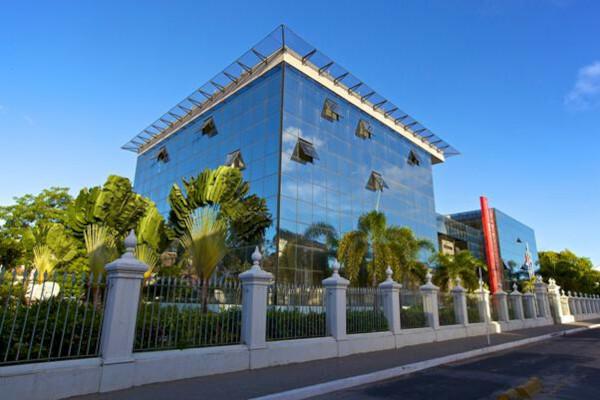
The city plays the role of seat of the state government, whose functions are carried out in the Palácio República dos Palmares, in the central region of the municipality.

Infrastructure of Maceio
Most households in Maceió are located in the urban area of the city, which is equivalent to 99.9% of a total of almost 274 thousand, as revealed by the 2010 IBGE Census. Data from the National Sanitation Information System (SNIS), compiled by the State Secretariat for Planning, Management and Heritage (Seplag) of Alagoas, indicate that, in its capital, 96.1% of the population have access to the water supply network. Sewage services serve a smaller percentage, 40.3%, while the electricity network covers almost all homes and establishments.
Urban displacements in Maceió rely, in addition to the vehicle fleet, which totaled 201,808 cars in 2010, bus lines and also with a commuter train system, which serves two other municipalities, with a total length of 32 km. It is in the capital of Alagoas the State's main airport, Zumbi dos Palmares Airport, which makes national and international connections. In addition, the city has the Port of Jaraguá or Port Maceio, an access route to maritime transport routes through which there are expressive cargo movements every year.
Culture of Maceio
Maceió has a great cultural diversity, fruit of the different ethnicities and nationalities of the peoples that gave rise to and make up the population of Macao and Alagoas. Part of the city's history is crystallized in the buildings that make up the Bariro do Jaraguá, considered a heritage of Alagoas for its buildings dating from the 19th century. The city hall, the convention center and the Brazilian Art Museum (MAB) are located in this neighborhood.
At folk expressions, notably through parties and celebrations, are very present in the city. The festivities calendar also includes events with a religious bias that cover religions of different origins. We can mention the reisado, the cavalhadas, the baianas (dancers), the bumba meu boi, the fandango and the caboclinho.
The municipality of Maceió is recognized for being the homeland of great names in popular culture Brazilian, such as:
musician and composer Djavan;
the writer Graciliano Ramos;
the filmmaker Cacá Diegues.

History of Maceio
The city of Maceio is located in a strategic position and that promotes access to the country's interior lands through its port area. As a result, the Dutch invasions that occurred in the North and Northeastern Brazil, in the 17th century, sparked the alert of the need to guarantee control over that area, which, until then, had no owner.
Historical records point out that the current city started at Engenho Massayó, a name of indigenous origin, attributed by the populations who lived there even before the arrival of the colonizers, and which means “what covers the marshland”. Nonetheless, the process of population in the region in the first decades of the 19th century is attributed (between 1815 and 1820), to the presence of the Port of Jaraguá, which was separated from Vila de Alagoas, in 1815.
Maceio's economy prospered through of the production of sugar millsand plant extractivism, thus becoming one of the main economic centers in the region. With the political emancipation of Alagoas, which took place in 1817, after its dismemberment from the captaincy of Pernambuco, the transfer of the capital to the thriving Maceió was considered. The process began even without unanimity. It was just in the year 1839 that the city of Maceió officially became the capital, thus consolidating itself as the economic and political center of Alagoas.
Image credits
[1] pink laurel / commons
[2] mateusfiuza / Shutterstock
By Paloma Guitarrara
geography teacher
