O Cearáis a Brazilian state in the Northeast region, located in the northeastern Sertão sub-region. It is characterized by the tropical semiarid climate, marked by low rainfall and long periods of drought.
In the economy, it stands out for the production of leather and derived products, a raw material that is also used in handicrafts. With over 9 million inhabitants, Ceará is one of the most populous states in the Northeast. The state is currently the third largest producer of wind energy in Brazil.
Read too: Alagoas – a state whose main economic activity is tourism
Ceara general data
- Region: North East
- capital: Strength
- Government: Camilo Sobreira de Santana (2018-2022)
- Areaterritorial: 148,894,441 km² (IBGE, 2019)
- Population: 9,187,103 inhabitants (IBGE, 2020)
- Densitydemographic: 56.76 inhab/km² (IBGE, 2010)
- spindle: GMT -3 hours (Brasilia Standard Time)
- Climate: predominantly Tropical Semiarid
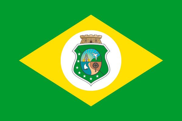
Flag of Ceara

Ceará geography
Ceará is one of the nine states that make up the rnortheastern region Brazil, in the northeastern Sertão sub-region. It is also inserted in the
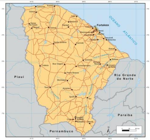
Drought Polygon, an area legally recognized and named because of the low rainfall and long periods of drought.It has a coastline of 573 km to the north, the third longest in the Northeast. It is limited to:
- to the east, with the large northern river and with the Paraíba;
- to the south, with Pernambuco;
- to the west, with the state of Piauí.
The territorial extension of Ceará is 148,894.44 km², which represents about 9.5% of the area of the Northeast region.
Do not stop now... There's more after the advertising ;)
Ceara climate
O climate predominant in Ceará is Tropical Semiarid. Its scope is even greater if one considers its variation, the mild semiarid, which appears mainly on the coast and south of the state. In some more isolated points, the occurrence of Humid and Subhumid Tropical climates is identified.
The main feature of the semiarid climate is the irregularity of rains, both in its spatial and time distribution, and the low general rainfall, which varies between 250 mm and 800 mm. The dry periods can be prolonged, lasting from months to years in a row. Between 2012 and 2016, for example, the average rainfall was 516 mm, considered the worst prolonged drought since 1910|1|.
Ceara vegetation
The vegetation cover of the state of Ceará is composed, in its majority, by characteristic species of Caatinga. Due to the different types of ground and due to the variation of climatic conditions, several physiognomies are identified, among which the arboreal caatinga, the shrubby caatinga and the hangman prevail.
On the coast of Ceará, the vegetation found is characteristic of wet areas, with the presence of restingas and mangroves. In other areas of the territory, formations such as the mminutes of cocals and the one of çwrongyou, these in isolated points.

Ceara relief
The largest portion of Ceará belongs to the domain of sertanejo and São Francisco depression. THE coastal plain it extends along the entire coastline of the state, where altitudes do not exceed 200 meters. Areas of Highland are found on the east, west and south edges of Ceara.
The peak of Serra Branca is the highest point in the state, with 1,154 meters of altitude.
Ceará Hydrography
Ceará is subdivided into 12 watersheds, the largest being the Alto Jaguaribe basin, in the southwest of the state. Among the rivers that bathe Ceará's territory, the following stand out:
- jaguaribe
- Parnaíba
- salty
- Ceará
- Coconut
- Banabuiú
- koreau
- Curu
- Acaraú
- Aracatiaçu
See too: São Francisco River – one of the most important water courses in Brazil
Ceará Demographics
IBGE estimates for 2020 indicate that Ceará has 9,187,103 inhabitants. It is the 8th most populous state in Brazil, and the 3rd in the Northeast region, just behind the Bahia and from Pernambuco. According to the last Demographic Census (2010), the population distribution was 56.76 inhab/km².
The largest portion of the Ceará population lives in urban areass. In 2010, the urbanization rate in the state was 75.1%. The capital, Fortaleza, is the city that aggregates the largest number of people: 2,686,612 (IBGE, 2020). Furthermore, it is the 5th most populous city in Brazil. Granjeiro is the municipality with the smallest absolute population, with 4,814 inhabitants.
Life expectancy at birth is 74.5 years, according to 2019 data. Due to the fall in birth and fertility, the population of Ceará has been growing at a slow pace|2|.
Ceara map

Geographical division of Ceará
The geographic division of Ceará, proposed by the IBGE until 2018, divided the 184 municipalities in the state in 33 micro-regions. These, in turn, were aggregated into seven mesoregions:
- northwest of Ceará
- North Ceará
- Metropolitan of Fortaleza
- jaguaribe
- Sertões Cearenses
- Center-South of Ceará
- South Ceará
Currently, IBGE divides Ceará into 18 immediate geographic regions and six intermediate regions, namely: Crateús, Fortaleza, Iguatu, Juazeiro do Norte, Quixadá and Sobral.
Read too: Socioeconomic regionalization of the world space
Ceará Economy
O Gross Domestic Product (GDP) of Ceará is BRL 155.9 billion, representing the 12th among the federation units and the 3rd largest GDP in the Northeast region. GDP per capita, in turn, is one of the lowest in the country, totaling R$17,178 in 2018.
O tertiary sector accounts for the largest portion of the state's economy, with great weight of the service sector and commerce. Tourism-related activities have gained increasing prominence not only in the Ceará economy but also in the regional context of the Northeast. The share of GDP corresponding to this activity is 5%.
The state's industry focuses on transformation activities.o, in which the production of leather and shoes, clothing and accessories, food, and civil construction activities stand out. Fortaleza concentrates most of Ceará's industries.
In the agricultural sector, the state of Ceará is a major producer of bananas, corn, beans, tomatoes, passion fruit, cashew nuts and cassava, in addition to eggs, milk and honey.
Ceará Government
The current governor of Ceará is Camilo Santana (PT), and the vice governor is Izolda Cela (PDT). In 2018, two federal senators were elected by the state. In addition to them, they represent Ceará 22 federal deputies and 46 state deputies.
Infrastructure of Ceará
Ceará's energy matrix is made up of thermal, wind, hydroelectric and solar, the first two being responsible for the largest portion of the energy generated in the state. With regard to thermal energy, energy generation takes place through sources such as diesel oil and natural gas.
in the sector wind, Ceará has one of the largest installed capacities in the country, second only to Rio Grande do Norte and Bahia. Until mid-2020, the state had 86 installed wind farms.
Between the The main airports are Fortaleza, with international flights, and Jericoacoara and Sobral. With regard to land transport, only the state highways in the state totaled 13,239.1 km in 2019. BR-116 is one of the federal highways that cross Ceará, starting in Fortaleza and reaching the extreme south of the country.
Ceará Culture
Ceará's cultural diversity comes from the different population influences of the territory, especially indigenous and African.
In addition to folklore and religious parties, handicraft is one of the main cultural expressions of the state. The pieces are made from leather, straw, clay, wood, colored sand and other elements.
THE literature of string and the woodcuts, made to represent the stories told in the form of verses, they are cultural symbols of the Northeast region, including the state of Ceará. Cordel was even recognized by IPHAN as Brazilian Intangible Cultural Heritage.

History of Ceara
At the Brazilian colonial period, the territory of Ceará constituted the hereditary captaincy of Siara. Initially she was attributed to Antônio Cardoso de Barros, who did not settle in the area. In 1603, Pero Coelho de Sousa explored the region until the prolonged drought that hit it and lasted four years. During this period, Fort São Thiago was built., later destroyed in a dispute with indigenous populations.
In 1612, the Portuguese known as the founder of Ceará, Martim Soares Moreno, arrived in the territory, building the Fort of São Sebastião. In addition to the reaction of the indigenous populations to the Portuguese settlers, there were conflicts with the Dutch who invaded the region.
The city of Fortaleza was formed around the Fort Fortaleza de Nossa Senhora de Assunção (formerly São Sebastião, who had been under Dutch rule), and officially established as the capital in the 18th century, in 1726.
Grades
|1| Ceará experiences the worst drought in over a century. Northeast Diary, September 13 2016. (Click here and access.)
|2| Ceará's population growth is slow, says IBGE. Northeast Diary, 31 August 2017. (Click here and access)
By Paloma Guitarrara
geography teacher
