Teresina is the capital of the state of Piauí, in the Northeast region of Brazil. The city is located on the border with the state of Maranhão, in the western portion of the territory of Piauí. It has an area of 1391 km² and has a semi-humid tropical climate.
The city's relief varies from lowered in the west, to more elevated and rugged as you walk to the east. The capital is the most populous city in Piauí, with 868,000 inhabitants. It is also the largest state economy, which is concentrated in the tertiary sector.
Read too: What are the state capitals of Brazil?
Summary about Teresina
Teresina is the capital of the state of Piauí.
It integrates the Integrated Development Region (Ride) Grande Teresina, formed by the municipalities of Piauí and Maranhão.
It extends over an area of 1391 km², and has a relief formed by plains and plateaus. The climate in the city is semi-humid Tropical.
It integrates the Cerrado biome.
It is the most populous city in Piauí, currently with 868,075 inhabitants.
The municipal GDP of Teresina is R$ 20.96 billion, with a greater participation of the tertiary sector.
Cattle ranching was of great importance for the formation and settlement of Teresina. This activity, together with the others that make up the primary sector, however, currently accounts for only 0.3% of GDP.
Teresina's cable-stayed bridge is one of the city's landmarks and a tourist attraction.
Do not stop now... There's more after the advertising ;)
Teresina's general data:
Gentile: teresina
-
Location
Parents: Brazil
Federative unit: Piauí
Intermediate region[1]: Teresina
Immediate region[1]: Teresina
Metropolitan region: belongs to the Integrated Development Region (Ride) Grande Teresina, which contains municipalities in Piauí and Maranhão.
Bordering municipalities: União, José de Freitas, Altos, Pau d'Arco from Piauí, Demerval Lobão, Nazária, Monsenhor Gil, Timon, Caxias.
-
geography
- Total area: 1391.3 km² (IBGE, 2020)
Total population: 868,075 inhabitants (IBGE, 2020)
Density: 584.94 inhab./km² (IBGE, 2010)
Climate: semi-humid tropical
Altitude: 92 meters
Time zone: GMT -3 hours
-
Historic
Foundation: August 16, 1852
Read too: Brasília – Federal Capital of Brazil
Teresina geography
Teresina is a Brazilian city located in the state of Piauí, in the Northeast region from the country. It houses the seat of the state government, thus playing the role of capital. It extends over a surface of 1391.3 km² or 0.55% of the Piauí area. The city is located in the north-central portion of the state, making border with two municipalities of the Maranhão (Timon and Caxias) and seven other cities in Piauí.
Although it does not belong to any metropolitan region, Teresina integrates the Integrated Development Region (Rgo) Great Teresina. The difference between Ride and RM lies in the fact that municipalities from more than one state are part of the integrated regions, as is the case we are dealing with here. Timon, in Maranhão, is part of Ride da Grande Teresina, in addition to the Piauí municipalities of Altos, Benedictinos, Coivaras, Curralinhos, Demerval Lobão, José de Freitas, Lagoa Alegre, Lagoa do Piauí, Miguel Leão, Monsenhor Gil, Pau D'Arco, União, Nazária and Teresina.
Teresina's climate
The climate in Teresina is tropical semi-humid. It is characterized by high temperatures during most of the year, and by the presence of two well-defined seasons, one being dry, which extends into the months of Winter and spring, and another rainy season, corresponding to the period of summer It's from autumn. The average temperature is 26 ºC, while the annual rains add up to 1365 mm.
Teresina relief
The capital of Piauí is included in the domain of plateaus and plateaus of the Parnaíba sedimentary basin. In the western portion of the city, on the border of which the Parnaíba river flows, the presence of plains and river terraces. As you walk to the east, the relief becomes more rugged and the elevations increase. Shapes such as hills and tables are common, in addition to the so-called witness hills.
Teresina Vegetation
The vegetation cover of Teresina belongs to the biome thick, being formed by fields, secondary forests and palm trees such as babassu.
Teresina Hydrography

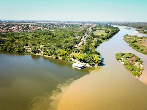
The Parnaíba and Poti rivers are the two main water courses in Teresina, with several tributaries. The first one runs to the west, on the border with Maranhão, while the second one starts in the Ceará, crosses Piauí, from the east, and flows into Parnaíba.
Teresina map

Teresina's Demographics
The city of Teresina has 868,075 inhabitants, the largest population contingent in the state of Piauí and the seventh in the Northeast region. This value corresponds to 26.5% of the population of Piauí. Taking into account all the state offices, Teresina appears in 17th place, according to the numbers of the IBGE for the year 2020.
The capital it is also the most densely populated municipality in Piauí., with demographic density of 584.94 inhab./km² (IBGE, 2010). A portion of 94.2% of the inhabitants of Piauí live in the urban area of the city, according to data from the latest IBGE Census. The others, who made up 5.7%, had their homes in the rural area of Teresina.
Most of Teresinenses declare themselves brown, being 59.82% of the entire population. The second group with the highest number of self-declared people is white, with 26.26%. Blacks represent 11.2% of the population of Teresina, while yellows and indigenous people are, respectively, 2.56% and 0.16%. It is also noteworthy that, although the composition by age shows a relatively young population, the scenario has gradually changed in recent years, indicating a process of population-ageing.
Check out our podcast: Aging population and economy
Geographical division of Teresina
The capital of Piauí is made up of 123 neighborhoods. They are subdivided into administrative regions or Superintendencies for Decentralized Administrative Actions (Saad). At four Saad of Teresina are named as follows:
North center
East
South
Southeast
Economy of Teresina
Teresina is the richest city in the state of Piauí, with Gross Domestic Product (GDP) of BRL 20.96 billion, according to IBGE data for 2018. On the national scene, the capital of Piauí ranks number 46 among all Brazilian municipalities. O tertiary sector is the economic segment that accounts for the largest number of people employed in the city and also for the largest share of its GDP, which is 61.13% – with the exception of public administration.
Teresina's industry is concentrated in sectors such as textiles, civil construction, food and beverage, chemical, pharmaceutical and agro-industrial. Taking into account the participation of this sector of the economy in the GDP, we have to secondary is responsible for 15.67% of its added value. Although located in a region of high agricultural dynamism, O primary sector accounts for a small portion of 0.3% of Teresina's GDP. The cattle herd and the production derived from it, such as dairy and meat and leather, and the raising of chickens, in addition to the cultivation of sugar cane, corn and rice, stand out.
Teresina government
The government of the municipality of Teresina is of the representative democratic type. This means that it is the population of Teresina who chooses and elects their representatives, which takes place through municipal elections held every four years. O Mayor is the head of FOROder ANDmunicipal executive, while the City Council, which is an organ of the Legislative Power, is composed of 29 councilors.
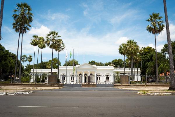
As the capital, Teresina is the seat of the government of the state of Piauí. The main administrative functions are performed at the Palace of Karnak.

Teresina Infrastructure
Most households in Teresina are in its urban area, and despite that, many structural problems can be identified. According to the IBGE, around 6% of homes are on roads with adequate urbanization, which includes manholes, pavement, curbs and sidewalks. We also remind you that this information refers to the last Demographic Census.
Adequate access to sewage services and the water network is, however, much more comprehensive. The share of households covered by these urban services is 61.6% and 93.3%, respectively. The electricity grid is connected to 99.8% of households in Teresina.
Several modes of transport are used for displacements both within Teresina and between the capital of Piauí and other regions of Brazil. The main one is the highway, being the city the crossing point of several federal and state roads, such as BR-226 and BR-343. The rail modal is used for transfers between the states of Piauí and Maranhão, through the São Luís-Teresina Railroad, which connects both capitals, and also internally, through the metro from Teresina. The capital of Piauí is also home to the main airport in the state, which is the Senador Petrônio Portella Airport.
Culture of Teresina
The Teresina culture expresses itself through various manifestations, as the countless folk legends, traditional festivals, dances, music, in literature, in crafts and through various other channels. Between the typical dances and parties meet the boom my ox, the reisado and the quadrille. At legends are carried out by characters such as Cabeça de Cuia, Zabelê and Miridam.
The tourist attractions of the capital of Piauí include natural and urban landscapes that serve as a point of visit. meeting for people from Teresina and for those who want to know a little better the city and its story. Yours natural spaces they earned it the nickname Cidade Verde, and among them are the Botanical Gardens, the Encontro das Águas Park and the City Park.
The cable-stayed bridge became one of Teresina's symbols, and a tourist complex which attracts numerous visitors, such as its gazebo. The Esperança Garcia Cultural Space and the Piauí Museum are also important cultural centers in the capital.

Teresina's Story
The livestock activity and the interiorization of the occupation of Brazilian territory promoted by the Bandeirantes are found at the origins of many of the municipalities in Piauí, including its capital, Teresina. The settlement of the area is attributed to Domingos Jorge Velho, even in the 17th century, and its economy revolved around animal husbandry, fishing and the planting of tobacco and cassava.
Under the name of village Poti, the city then became the capital of forprovince of Piauí in the 19th century, which was mainly due to its proximity to one of the main rivers in Piauí and the possibility of using this course as a means of transport for the flow of goods. The name Teresina was adopted from 1852 onwards, name that appeared as a tribute to the empress Teresa Cristina Maria de Bourbon.
The city of Teresina was planned, which can be observed based on its grid plan. Since its installation, it has gone through an intense period of urbanization, a process that gained even more strength from the first decades of the 20th century. Teresina is currently the main urban center in Piauí, with more than 860 thousand inhabitants.
By Paloma Guitarrara
geography teacher


