At Geographical coordinates they form a location system that is structured through imaginary lines, drawn parallel to each other in the north-south and east-west directions, measured in degrees. With the combination of these lines, specific “addresses” are created for each point in the world, allowing for their precise identification.
These imaginary lines are called parallels and meridians, and their measurements in degrees are, respectively, the latitudes and the longitudes. The parallels cut the Earth horizontally, in an east-west direction, while the meridians cut the Earth vertically. The joining of these lines is the factor responsible for the existence of geographic coordinates.
The main parallel is the equator line, as it represents the strip of the Earth that is at an equal distance from the north and south poles. The main meridian is the one of Greenwich and was chosen from a convention, held in the city of Washington DC, in the United States, in the year 1884. These two lines represent the starting point for counting latitudes and longitudes.
For this reason, everything that lies exactly on the Equator has a latitude of 0º, increasing as it moves north and decreasing as it moves south. Thus, latitudes are the distance in degrees of any point on Earth from the Equator. Its measurements range from -90º to 90º.
The same happens with the Greenwich Meridian in relation to longitudes. Everything on that line is 0° long, increasing as we move east and decreasing as we move west. That is why, longitudes are the distance in degrees from any point on Earth to the Greenwich Meridian. Its measurements range from -180º to 180º.
Observation: It is from the longitudes that the time zones.
Given this concept, we can conclude that negative latitudes are always referring to places located in the Southern Hemisphere, also called Southern or Southern. Positive latitudes, of course, refer to places positioned in the Northern Hemisphere, also called the Boreal or Northern.
Negative longitudes refer to points located in the Western or Western Hemisphere, while positive longitudes refer to points located in the Eastern or Eastern Hemisphere.
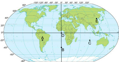
The following map provides global geographic coordinates established from the combination of latitudes and longitudes.

Geographic coordinates allow the location of different points on the map
Above, we have the representation of five different points. Observing their latitudes and longitudes, we can then describe the geographic coordinates of each one of them, indicating their hemispheres (North: N. South: S. East: E. West: W).
Point A:
Latitude: -20º or 20ºS
Length: -60º or 60ºW
Point B:
Latitude: -40º or 40ºS
Longitude: 0º
Point C:
Latitude: -20º or 20ºS
Longitude: 90º or 90ºE
Point D:
Latitude: 0º
Longitude: 0º
point E:
Latitude: 40º or 40ºN
Longitude: 120º or 120ºE
Note that all points on the surface are located in at least two hemispheres. The Brazilian territory, in this case, is found in three hemispheres: a small part in the north, a large part in the south and all of it in the west.
By Rodolfo Alves Pena
Graduated in Geography
Source: Brazil School - https://brasilescola.uol.com.br/geografia/coordenadas-geograficas.htm
