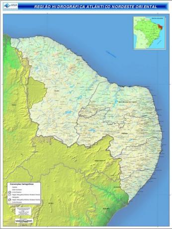
THE East Northeast Atlantic Hydrographic Basin it is one of the 12 hydrographic regions in Brazil.
It is formed by several sub-basins (hydrographic units) of which the following stand out: the Jaguaribe River Basin, Goiana Basin, Ipojuca Basin, Paraíba Basin and Piranha-Apodi Basin.
Characteristics and Importance

The Eastern Northeast Atlantic Hydrographic Basin is located in the northeast of the country, and covers the states of Ceará, Rio Grande do Norte, Paraíba, Pernambuco and Alagoas.
It occupies an area of approximately 287 thousand km², equivalent to 3% of the national territory.
It is located in the intertropical region (between tropics) and has small thermal range (little variation between the highest and lowest temperature).
The biomes that are part of this hydrographic region are the Caatinga, a Atlantic forest, O thick and the Mangroves.
The East Northeast Atlantic Hydrographic Basin has great economic and social importance for the region, as it encompasses about 740 municipalities and the five important capitals of the northeastern states (Fortaleza, Natal, João Pessoa, Recife and Maceio).
The demographic density of the region is 21 million inhabitants, representing about 12% of the country's population.
With the unrestrained exploitation, deforestation, the development of agriculture, livestock and the urbanization process, the region has been presenting several impacts environmental, such as the contamination of water especially by the release of sewage, fertilizers and pesticides, loss of fauna and flora, desertification, among others.
Many rivers that make up the basin are temporary rivers, that is, they present times of drought, which make navigation impossible.
Meet the Hydrography of Brazil.
rivers
Although the region does not have large rivers, the main ones that make up the East Northeast Atlantic Hydrographic Basin are:
- Jaguaribe River
- Capibaribe River
- Capibarib-Mirim
- Rio Mamanguape
- Paraíba River
- Jaguaribe River
- Acaraú river
- Rio Acu
- Apodi river
- Piranha-Açu River
- Una river
- Pirangi river
- River Pots
- Mundaú River
- Goiana River
- Ipojuca River
- Jaboatao River
- Rio Salgado
- River Curu
- Itaperoá River
know more about Hydrographic basin.


