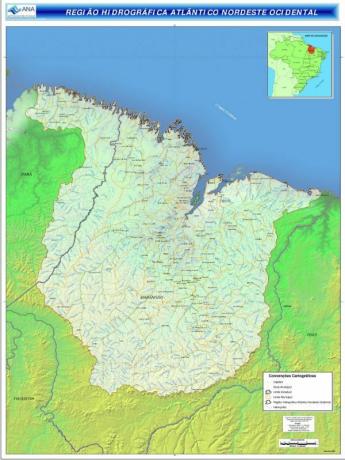
THE Western Northeast Atlantic Hydrographic Basin it is one of the 12 hydrographic regions in Brazil.
It is formed by several sub-basins, among which the Gurupi Basin, Pericumã Basin, Itapecuru Basin, Mearim Basin, Munim Basin and Turiaçu Basin stand out. The main aquifers in the region are Itapecuru, Motuca and Corda.
Characteristics and Importance

The Western Northeast Atlantic Hydrographic Basin is located in the northeast and north regions of the country. Thus, it occupies a large part of the west of the state of Maranhão (about 90%) and a small portion of the northern region, in the east of the state of Pará (about 10%).
It occupies an area of approximately 268,000 km², which corresponds to about 3% of the national territory. In the region, it is present in the biomes of Amazon It's from thick and it has great socioeconomic importance for the population that lives in the place.
It is located in the intertropical region (between the tropics) and has a hot and humid climate, with an average annual temperature of 27°C and low
thermal range.However, the unrestrained exploitation, the expansion of urbanization, agriculture and livestock, deforestation, river pollution, predatory fishing, the extraction of minerals, has generated several environmental problems, such as the degradation of fauna and flora, siltation of rivers, erosion, which directly affect the lives of its population. This occurs mainly in metropolitan regions, where around 60% of the population lives.
According to surveys by the IBGE (Brazilian Institute of Geography and Statistics), the region of the Western Northeast Atlantic Basin covers 223 municipalities and is home to around 6 million inhabitants.
Meet the Hydrography of Brazil.
rivers
The main rivers that make up the Western Northeast Atlantic Hydrographic Basin are:
- Gurupi River
- Gurupi-Mirim River
- Itinga River
- river thoughí
- River Caete
- Piriá river
- Rio Caripi
- Maracana River
- Pericuma River
- Aura River
- Turiaçu River
- Maracacumé River
- Grajaú River
- River Mearim
- river flowers
- Rio Munim
- Itapecuru River
- river currents
- Peritoro River
- Pindaré River
know more about Hydrographic basin.


