
Brazil is divided into five regions: North, Northeast, Midwest, Southeast and South.
The 27 states of the federation are grouped in them.
The territory of Brazil underwent changes during its formation. Some regions were lost, such as Cisplatin, while others were incorporated, such as Acre.
Current Brazil regional division

Currently, Brazil is divided into five regions:
- North Region: Amazonas, Pará, Roraima, Amapá, Rondônia, Acre and Tocantins.
- Northeast Region: Piauí, Maranhão, Pernambuco, Rio Grande do Norte, Paraíba, Ceará, Bahia, Alagoas and Sergipe.
- Midwest Region: Mato Grosso, Mato Grosso do Sul and Goiás.
- Southeast Region: São Paulo, Rio de Janeiro, Espírito Santo and Minas Gerais.
- Southern Region: Rio Grande do Sul, Paraná and Santa Catarina.
The last change in the configuration of the map of Brazil occurred in 1990 with the creation of the state of Tocantins, included in the northern region.
Brazilian regional division through history
Since the Hereditary Captaincies, in 1534, until the creation of the state of Tocantins, in 1990, several changes were made in the design of the Brazilian map.
Likewise, as the population grew, it was necessary to organize the territory to better manage it.
Let's see how Brazilian regionalization took place:
1822
At the time of Brazil's independence, the country was not divided into regions. The territorial configuration was as follows:
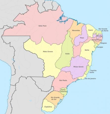
Brazil had 19 provinces, among which was Cisplatina, now Uruguay. We also see that the current northern region was not sub-divided and the entire territory was called Grão-Pará.
However, in 1828, the province of Cisplatina achieves its independence and Uruguay emerges.
1889
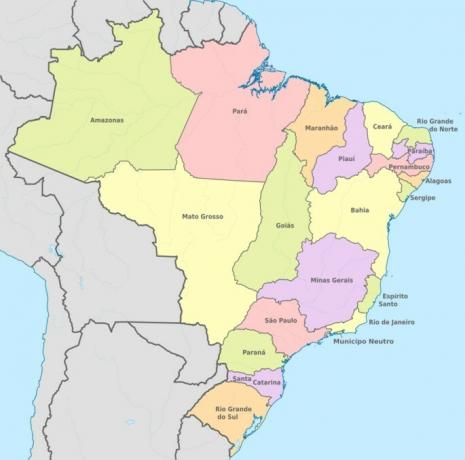
In the year of the installation of the republican regime, Brazil was divided into 20 states.
In 1853, Paraná had emancipated itself from São Paulo, constituting an autonomous territory and the province of Grão-Pará is divided into two, giving rise to the states of Amazonas and Pará.
1913
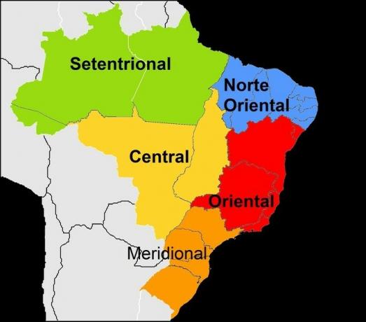
The first proposal for a regional division in Brazil was made in 1913, in order to improve the teaching of geography in schools. The country was divided into five regions according to physical aspect: North, North East, East, South.
The states of Amapá, Roraima or Mato Grosso do Sul, for example, did not yet exist.
1940
Brazil is now divided into five regions: North, Center, Northeast, South and East.
With the increase in migration from the Northeast to the Southeast, another regional division was carried out, this time by the IBGE (Brazilian Institute of Geography and Statistics).
Created in 1936, this organization would be responsible for collecting statistical data about the country and helping in public administration.
At that time, the states of Paraná, Santa Catarina, Rio Grande do Sul, São Paulo and Rio de Janeiro belonged to the southern region.
1945
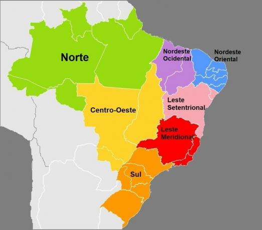
Brazil was divided into seven regions: North, Northeast West, Northeast East, Midwest, East North, East South and South.
Territories such as Rio Branco (current state of Roraima) and Iguaçu (western portion of Santa Catarina and Paraná) were created.
1960
The 1960s brought important changes to the map of Brazil, although the seven regions have not changed.
The capital of Brazil was transferred to Brasília, on April 21, 1960, in the Midwest region. Thus, the neutral municipality of Rio de Janeiro becomes the state of Guanabara, while the remaining territory is called Rio de Janeiro.
In 1962, the Federal Territory of Acre was elevated to a state and the Federal Territory of Rio Branco was renamed the Federal Territory of Roraima.
1970
In this decade, the five major regions we know today were established: North, Northeast, Midwest, South and Southeast.
In 1975, the state of Guanabara is extinct, merges with the state of Rio de Janeiro, becoming its capital.
Four years later, the state of Mato Grosso is dismembered to create the state of Mato Grosso do Sul whose capital is Campo Grande.
1990
The north of Goiás becomes the state of Tocantins and its capital is the city of Palmas.
The 1988 Constitution extinguishes the last federal territories in Brazil, Amapá and Roraima, which are elevated to the status of states.
The Fernando de Noronha archipelago is also no longer a federal territory and becomes a district of the state of Pernambuco.
We have more texts on the regional division of Brazil:
- North region
- Northeast region
- Midwest region
- South region
- Southeast region

