The Legal Amazon is an area of 5,217,423 square kilometers, comprising 61% of the entire Brazilian territory.
We should not confuse the Legal Amazon with the Amazon biome, the latter is an expanding ecosystem for other countries, while the term Legal Amazon is a political definition instituted by the Brazilian government.
Location and features
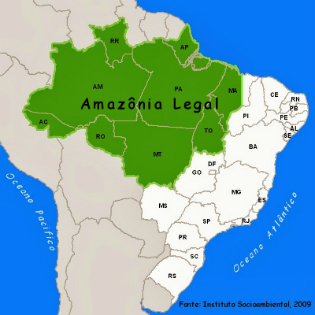
The Legal Amazon covers nine states in Brazil: Acre, Amapá, Amazonas, Mato Grosso, Pará, Rondônia, Roraima, Tocantins and a part of the state of Maranhão.
In addition to comprising the entire Brazilian Amazon, it also covers a small portion of the biomes thick and wetland.
The main economic activities developed in the region are agriculture, livestock and extractivism. Regarding the performance of industries, the Manaus Free Zone, in the State of Amazonas.
Currently, one of the biggest problems faced by the Legal Amazon is related to excessive deforestation. This factor has compromised the ecosystem as well as the populations that live in it.
About 55% of all indigenous peoples that inhabit Brazil live in the Legal Amazon area. The degradation of the environment, enhanced by the logging, directly affects the conservation of the natural environment and has serious consequences for the Amazon ecosystem.
In addition, the construction of hydroelectric plants in the region significantly affected the lives of these people. Since the Indians live off hunting and fishing, with the increasing degradation of the place in recent decades, they have been facing serious problems with the lack of resources.
Why was it created?
The Legal Amazon was created during the government of Getúlio Vargas, through the Superintendence of the Plan for Economic Valorization of the Amazon (SPVEA), a body that has already disappeared.
Through Law No. 1,806 of January 6, 1953, the economic valuation plan for the Amazon was established. When it was enacted, the objective was to promote the economic and social development of the region, where around 20 million people live.
Art. 1st The Amazon Economic Valorization Plan, provided for in Art. 199 of the Constitution, constitutes a system of measures, services, undertakings and works, intended to increase the development of extractive and agricultural production livestock, mineral, industrial and exchange relations, towards better social standards of living and economic well-being of the region's populations and the expansion of Country's wealth.
Amazon International
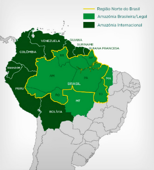
The international Amazon corresponds to an area north of the South America, which covers nine countries: Brazil, French Guiana, Suriname, Guyana, Venezuela, Colombia, Ecuador, Peru and Bolivia.
Despite its large area, approximately 60% of the Amazon occurs in Brazilian territory.
This region comprises the largest tropical forest of the world and also the largest hydrographic basin, formed by the Amazon river and its tributaries.
Learn more, read too:
- Amazon
- Amazon Basin
- Amazon rainforest
Fell in Enem!
(Enem-2013) In recent decades, the territory has undergone major changes due to technical additions that renew their materiality, as a result and condition, at the same time, of the economic and social processes in course.
SANTOS, M.; BLACKTHROOM; M. L. Brazil: territory and society at the beginning of the 21st century. Rio de Janeiro: Record, 2004 (adapted)
From the last decade, there has been the occurrence in Brazil of significant changes in the territory, causing social, cultural and economic impacts on local communities, and with greater intensity, in the Amazon Cool, with:
a) renovation and expansion of airports in state capitals.
b) expansion of soccer stadiums for sporting events.
c) construction of hydroelectric plants on the Tocantins, Xingu and Madeira rivers.
d) installation of cables for the formation of a computerized communication network.
e) formation of an infrastructure of towers that allow mobile communication in the region.
Alternative c: construction of hydroelectric plants on the Tocantins, Xingu and Madeira rivers.
See too: all about the Amazon