Cartographic projections bring together the forms of representation of maps and lines called latitude and longitude.
According to the intended objective, a type of projection is used, which provides greater rigor in the spatial representation.
Thus, the main objective is to reduce imperfections in the maps, whether in scales or in the angles presented.
This is because, in reality, maps do not present a real image of the regions, that is, they are drawn that approach each other.
Types of Cartographic Projections
To represent the terrestrial globe in a plane, three types of projections:
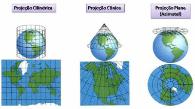
Types of Cartographic Projections
- Cylindrical Projection: it's like a cylinder enveloping the terrestrial globe. In this case, parallels and meridians are represented by straight lines that converge with each other. A notorious example is the representation of the world map as we know it.
- Conical Projection: it's as if a cone surrounds part of the globe. It is often used to represent continental regions. In this case, the parallels represent concentric circles, while the meridians are straight lines that converge towards the poles.
- Plane Projection: also called “azimuthal projection”, it is a tangent plane to the terrestrial sphere. In this case, the parallels represent concentric circles, while the straight meridians radiate from the pole. Depending on the intended representation, they are classified in three ways: Polar, Equatorial and Oblique.
Of the three models presented above, we have several types of projections that have been studied by many geographers. The most important are:
Mercator projection
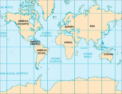
Mercator projection
Created by cartographer, geographer and mathematician Gerhard Mercator (1512-1594), the Mercator projection is one of the most used.
In this type of cylindrical projection of the globe, the angles and shapes of the continents are conserved, however, the areas are deformed.
This model is included in the category of "conformal proportion", being widely used in navigation and aeronautics.
Peters projection
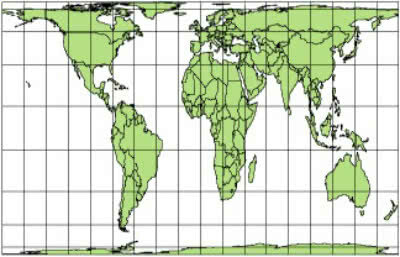
Gall-Peters Projection
It was elaborated by the Scottish James Gall (1808-1895) and later taken up by the German historian Arno Peters (1916-2002). For this reason, it is also called the Gall-Peters Projection.
It is a type of cylindrical projection that preserves the proportions between the areas, however, the angles and shapes of the continents are altered. This model is included in the so-called "equivalent ratio".
Robinson's projection
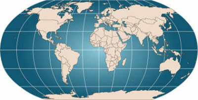
Robinson's projection
It was created by the American geographer and cartographer Arthur H. Robinson (1915-2004). This type of cylindrical and aphylactic projection alters the shapes and areas of the continents. Therefore, it is in the category of non-equivalent and non-compliant.
In it, the meridians are the curved lines, while the parallel ones are the straight lines. Currently, this model is used to represent the World Map, and is therefore the best known.
Parallels and Meridians
The parallels and meridians are imaginary lines on the terrestrial globe. Thus, parallels are lines drawn horizontally, while meridians represent vertical lines.
Read too:
- Parallels and Meridians
- Latitude and longitude
Entrance Exam Exercises with Feedback
1. (UESC) Knowledge about cartographic projections and the use of maps make it possible to state:
a) The azimuthal projection provides a Eurocentric view of the world and, therefore, it is no longer used.
b) The distortions of representation, in the cylindrical projections, are greater in Ecuador and smaller in the poles.
c) Peters' projection is the only one that does not intend to privilege any continent, because it rigorously reproduces reality.
d) The conical projection can only be used to represent large regions, because distortions are small between the tropics, therefore not representing the reality of the mapped areas.
e) Cartographic projections allow, in the construction of thematic maps, the meridians and the Earth parallels are transformed from a three-dimensional reality to a reality two-dimensional.
a) incorrect
b) incorrect
c) incorrect
d) incorrect
e) correct
2. (PUC-PR) Pay attention to the map below

The planisphere was cartographically elaborated through the Gall-Peters Projection, initially conceived by James Gall in the late 19th century and resumed by Arno Peters from the middle of the following century, whose political and economic context strongly influenced him in the development of this map.
Check the alternative whose characteristic corresponds to the Gall-Peters map:
a) This is an equivalent projection that aims to represent a more or less faithful portrait of the size of the areas, which makes Africa and South America stand out more than when represented in the Projection of Mercator.
b) It corresponds to a conic-type projection, which distorts the areas located at low latitudes and makes the representation of the regions of medium and high latitudes more faithful.
c) It is a projection whose main quality is the respect for the shapes of the continents, seeking to represent them faithfully, unlike the areas that are shown unevenly, being larger near the poles and reduced in the range intertropical.
d) The perpendicular arrangement of the network of parallels and meridians in this map reveals that the Gall-Peters projection is of the azimuthal or polar type.
e) Peters, who resumed the elaboration of this projection during the period of the "Cold War", sought to emphasize on the map, the from the representation of the dimensions of the areas, the superiority of the United States over other parts of the globe.
Alternative to
3. (UNICAMP) A world map in the Mercator projection is reproduced below.
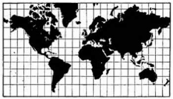
It is possible to say that, in this projection:
a) the meridians and parallels do not intersect at 90° angles, which promotes an increase in continental masses at high latitudes.
b) the meridians and parallels intersect at 90° angles, which distorts the terrestrial portions close to the poles more and less the portions close to the equator.
c) there are no distortions in the continental masses and oceans at any latitude, allowing the use of this map for maritime navigation up to the present day.
d) the meridians and parallels intersect at perfect angles of 90°, which makes it possible to represent the Earth without deformations.
a) incorrect
b) correct
c) incorrect
d) incorrect
Read too:
- What is Cartography?
- Cartographic Scale Exercises
- Brazil's map
- World map
- Thematic Maps
- Geographical coordinates


