A watershed is a portion of the earth's surface drained by a main river, its tributaries and sub- tributaries. According to the National Water Resources Council (CNRH), Brazil has 12 hydrographic regions.
Occupying an area of 967 thousand square kilometers (11% of the national territory), the Tocantins-Araguaia Basin is the largest hydrographic basin exclusively in Brazil. It is present in the states of Mato Grosso, Goiás, Tocantins, Pará and Maranhão, in addition to the Federal District.
The average flow corresponds to 9.6% of the country's total. The main rivers are the Tocantins and Araguaia. The Tocantins River, 1,900 km long, is born in the state of Goiás, and its main tributary is the Araguaia River, 2,600 km long.
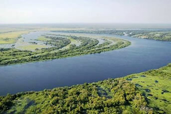
The Araguaia River, together with the Javaés, involves the largest fluvial island in the world: Bananal Island, which is 350 kilometers long and 80 kilometers wide.

Bananal Island
The rivers of the Tocantins-Araguaia Basin are extremely important for the population of these states.
About 8 million people reside in this basin area. The hydroelectric potential is used through the construction of several hydroelectric plants, such as Serra da Mesa, Tucuruí, Canabrava, among others.Mining and agriculture are the main activities responsible for the pollution of the rivers of the Tocantins-Araguaia Basin. At the Carajás Mineral Complex, manganese, copper, gold, nickel, iron ore, etc. are extracted. Chemicals used in mining pollute rivers.
By Wagner de Cerqueira and Francisco
Graduated in Geography
Kids School Team


