By the end of the 19th century, the sciences already knew all parts of the Earth. All countries were somehow intertwined in economic and political relations. However, there was still no standard regarding the way in which different locations measured time, which created many problems.
Because of this, in 1881, the leaders of 25 countries – among them, Brazil – met in the city of Washington, capital of the United States, to try to solve this great problem. In this conference, they decided to divide the Earth into 24 parts, because they knew that the Earth took 24 hours to go around on its own axis (rotation) and complete one day.
Thus, each of these parts – which were called time zones – counted one hour and averaged 15th. As you moved east, you added one hour per time zone, and as you moved west, you decreased one hour per time zone. In this way, all countries could measure their hours in harmony with each other.

Different locations around the world had their schedules defined in relation to the whole.
Another decision taken at the Washington Conference was the definition of the starting point from which the zones would be counted. As the city of London was the capital of the main country at the time - England -, it was defined that this starting point should be there and created the Greenwich Meridian to exercise this function.Therefore, on this meridian, was the first spindle. To everything that was to the east, hours were added, and to everything that was to the west, the hours were shortened.
However, a new problem was detected. The division of the Earth into time zones or meridians did not coincide with the borders and territorial divisions of countries and cities. So, in one place, it could be an hour, and very close by, it could be another hour.
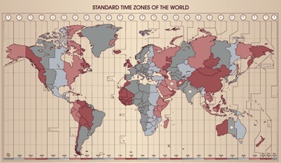
To further solve this problem, the so-called legal time was created, in which countries had autonomy to regulate their official time, based on time zone lines and respecting their borders. Look at the map below and try to understand the different distributions of time zones around the world, with the necessary territorial adaptations carried out by the countries.

Note on the map that the legal hours for each country are represented by different colors.
Understanding time zones is very important to easily find the time in other parts of the world. This allows us to plan trips and events, as well as helping us to find out, for example, the best time to call a friend who lives in another country.
By Rodolfo Alves Pena
Graduated in Geography

