
Brazil has 93% of its territory located in the Southern Hemisphere, the remainder (7%) is in the Northern Hemisphere, this means that the territory is in the intertropical zone of the planet, with the exception of the South region.
Due to the immensity of the Brazilian territory (8 514 876 km²), several types of climates, the main ones being: equatorial, tropical, altitude tropical, humid tropical, semiarid and subtropical.
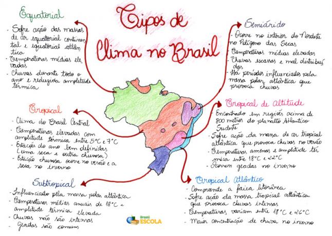
Mind Map: Types of Climate in Brazil
* To download the mind map in PDF, Click here!
the equatorial climate it is identified in almost every state in the North region, in addition to part of Mato Grosso and Maranhão. This climatic characteristic is characterized by high temperature, high humidity and low temperature range, varying between 24°C and 26°C per year. The amount of rain is abundant, with pluviometric indexes above 2,000 mm, practically no dry periods are noticed. The Amazon rainforest is influenced by this climate.
the tropical climate it influences much of the center of the country, especially the states of the Midwest, including parts of Maranhão, Piauí, Ceará, Bahia and Minas Gerais. In general, temperatures are high for most of the year, with an average of 24°C, and the temperature range varies between 5°C and 6°C per year. The amount of rainfall is around 1,500 mm per year, with two well-defined seasons: a dry (May to September) and a rainy (October to April) season.
Do not stop now... There's more after the advertising ;)
The tropical climate of altitude it is found in mountain and plateau regions, especially in the Southeast region. In these places there is low thermal amplitude, the average temperature oscillates between 17°C and 22°C, and the amount of rain is 1,500 mm per year.
The humid tropical climate occurs mainly on the eastern and southern coast of Brazil, being characterized by high temperature and high moisture content. The annual average temperatures are around 25°C and the pluviometric indexes between 1250 mm and 2,000 mm.
the semiarid climate it is typical of the Northeast region, especially in the interior, a place known as the drought polygon, due to the lack of rain. It presents high temperatures throughout the year, the annual average varies between 26°C and 28°C. Rains are scarce, with an annual average of less than 750 mm, in addition, they are poorly distributed.
The subtropical climate occurs only in the southern region, this climatic characteristic is totally different from the rest of Brazil. Annual temperature averages are around 18°C, with a high thermal amplitude. The rains are well distributed, the pluviometric indexes exceed 1,250 mm per year.
By Eduardo de Freitas
Graduated in Geography
*Mental Map by Rafaela Sousa
Graduated in Geography
Would you like to reference this text in a school or academic work? Look:
FREITAS, Eduardo de. "Brazilian climate"; Brazil School. Available in: https://brasilescola.uol.com.br/brasil/clima-brasileiro.htm. Accessed on June 27, 2021.