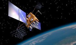
Remote sensing is the use of electromagnetic radiation to collect images and data over the earth's surface. With this technology, information is collected by sensors that are far from the object or area being analyzed.
The material collected through remote sensing is very accurate and authentic. Therefore, it is a reliable source for the construction of maps or detailed studies.
This technology is used for many purposes, such as observing Earth features, natural phenomena, weather events and urban growth.
Typically, the sensors that collect the data are transported by satellites, aircraft and drones, but they can also be transported by any other means, such as cars or people. A satellite that makes images of the Earth is one of the best-known examples of remote sensing.
How does sensing work?
The functioning of remote sensing depends on three basic elements:
- object/area observed;
- electromagnetic radiation (REM): waves or particles that move at the speed of light;
- sensor: which measures the intensity of radiation.
To collect the information, the satellite uses solar radiation reflected by the Earth's surface, which is captured by the remote sensor.
Sensors detect radiation at different wavelengths, many of them invisible to the naked eye. Once detected, they are converted to visible colors.
Then, the data collected by the sensor is transmitted to a central that collects, organizes and stores the information, such as GIS, the Geographical Information System (or GIS - Geographic Information System).
In Brazil, much of the data collected from remote sensing is used by INPE (National Institute for Space Research) and by INMET (National Institute of Meteorology).
What types of remote sensing?
Sensors are divided into two types, depending on the radiation source they use: passive or active.
- passive sensors: are the sensors that use external electromagnetic radiation, from sunlight;
- active sensors: these sensors have their own radiation source, not depending on external radiation.
 Passive sensors use their own radiation source (white arrows) and passive sensors use external radiation (yellow arrows).
Image Collection Levels
In general, the images collected by the sensors are on a small scale and, because of that, large areas can be observed in a short time.
Depending on the level at which the sensor is placed, captured images may have more or less detail. The biggest difference between the levels is the size of surface it analyzes (according to the distance between the area and the sensor).
There are three levels of data collection:
- ground: are the images collected at the level close to the ground, collected by people (hand sensors) or by vehicles. Because it is very close to the ground, this type of sensing is only able to observe small areas, but it can get more details.
- air: in aerial sensing, the sensors are attached to aircraft or drones, which record images of the earth's surface.
- orbital: are sensors connected to artificial satellites, which are further away from the Earth. Their biggest advantage is the large expanse they are able to see. Depending on the type of technology used, they may be able to reveal more or less details of the area.
What is remote sensing for?
Remote sensing technology has numerous functions, as the system can be used to observe many types of surface, collecting images that will be transformed into data. Nowadays, one of the most used remote sensing techniques is the satellite, which orbits around the Earth.
Because it has many applications, remote sensing is one of the instruments most used by geotechnology, an area that uses different technologies to collect, organize and analyze geographic data.
You main uses of the remote sensing are:
- creation of maps with varied data (cartography): geography, topography, hydrography, relief, vegetation, among others;
- observation of the use of natural resources;
- creation or updating of real-time maps and GPS;
- observation of climate change and prediction of meteorological phenomena;
- monitoring the growth of cities;
- data collection for urban planning;
- measurement of ocean levels;
- control of deforested areas;
- observation of areas used in agriculture.
 Image of the Earth captured by a satellite orbiting the planet.
How did remote sensing come about?
Remote sensing technology emerged during the First World War (1914-1918), when it was used area photography (aerophotogrammetry) to recognize targets and facilitate operations planning military.
A few decades later, starting in the 1960s, remote sensing began to be used as we know it today, to collect images and information.
During the Cold War (1947-1991), the use of remote sensing grew a lot and it was used by the United States and the Soviet Union.
The first Earth observation satellite was sent to space by NASA in 1972, it was called LANDSAT-1. The observation project still exists and the last satellite in this series, LANDSAT-8, was sent into space in 2013.
The first Brazilian observation satellite, the SCD-1, was sent into space in 1993.
See also the meanings of satellite and solar radiation.

