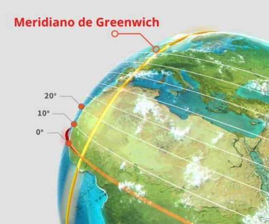
O Greenwich Mean Time it was so named thanks to the English quarter that bears that name. In it was located the Royal Astronomical Observatory, an important institution for world astronomy and for knowledge of events in the ssystem Solar. This Observatory gained even more relevance in 1884, at the time of the imperialism and when the United Kingdom had great force in world geopolitics, as it was its main power.
Read too: Map of Brazil - cartographic representation of our country
History of the Greenwich Meridian
Until 1884, the nations of the world did not know a schedule standardization as we know it today. In 1851, George Biddel Airy suggested that the Greenwich site be used as ground zero for this, and many countries began to adopt it.
Until then, a country's local time was not related to its geographic position in relation to the Sun. Thus, when an event took place in Brazil, at 10 am, an inhabitant of South Africa did not have the less idea of the exact moment of this event taking into account its own territory, by example.
This lack of standard in world timetables generated certain inconveniences, as a ship leaving Europe bound for the United States he had no idea what time he would arrive at his destination, as each country regulated its time according to regional demands.
It was only in 1884 that the United States government decided to make Greenwich's choice of ground zero official. In the same year, in the city of Washington, in the same country, 25 nations got together and defined that we should have a zero meridian for all countries in order to calculate the timezone of each nation, plus a standard date.
From then on, the Greenwich Meridian was chosen for locating the Royal Astronomical Observatory. This observatory has been extremely important to European navigators since the 18th century, as it was held there astronomical calculations for navigations, which contributed to the United Kingdom being a great power of the era.
Do not stop now... There's more after the advertising ;)
Greenwich Meridian and Time Zone
By being designated as the zero point for the calculation of hours and, consequently, for the establishment of time zones, the Greenwich meridian set a pattern to be followed, making life easier and lessening the confusion that existed about the hours.
To understand this pattern, we must know that the Earth it has a spherical shape, known as a geoid. When we divide the corresponding 360º of the planet by the number of hours in the day, 24, we have a total of 15º. Thus, every 15º away from Greenwich, we have a variation of one hour, more or less. the period of one hour is the same as the Earth's 15° movement.
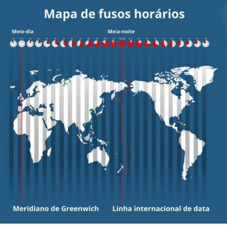
as the rotation movement Earth is counterclockwise, locations in the Eastern Hemisphere are hours ahead of Greenwich, and locations in the Western Hemisphere are behind in their time. Based on that meridian, time zone is negative for west and positive for east, subtracting or adding the hours, respectively.
An example: if in London it is 17 hours, in Brasília (Brazil's official time) it will be 12 hours, as the Federal District of our country is located in the 45º west zone (three hours less than the difference).
With these calculations, it's simple to figure out what time an event in Asia will be broadcast to America live, in real time, as would be the case with the Tokyo Olympics.
In countries with a large territorial extension, the 15º range of time zones is not always respected. Imagine that a city is cut by two spindles. This would generate an expressive local disorder, with an hour difference for each side. Thus, many governments extend the ranges to their borders or to poorly habitable places, to have a standard time.
See too: Latitudes and longitudes: what does each represent?
Places cut by the Greenwich Meridian
The Greenwich Meridian crosses the world from north to south, passing through the following locations:
Arctic Ocean
Greenland Sea
Norwegian Sea
North Sea
UK
English Channel
France
Spain
Mediterranean Sea
Algeria
mali
Burkina Faso
Togo
Ghana
Atlantic Ocean
Antarctica
Parallels and Meridians
Parallels and meridians are imaginary lines that circle the Earth from east to west and north to south. These lines are widely used in geographic coordinates (latitude and longitude) and in the time zone calculation, in addition to defining the thermal zones of the planet, like the Tropic of Cancer and the Tropic of Capricorn.
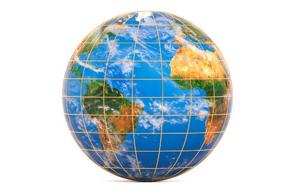
You parallels are imaginary lines perpendicular to the central axis. (Greenwich Meridian) and parallel to each other, dividing the world into two hemispheres: North and South. The parallel with the largest circumference is the equator line, with the longest radius on the globe. Furthermore, it is the parallels that determine the latitudes.
It is based in Ecuador that we have the North and South geographic division. On this parallel is the 0º measurement, the area most illuminated by the planet's solar rays.
You meridians are imaginary lines that follow the axis of the planet and determine the longitudes. Every meridian has its antimeridian, which is opposite to it, on the other side of the globe.
As an example, there is the Greenwich Meridian, which is the 0º meridian with the International Date Line, corresponding to the 180º meridian.
These are the meridians that geographically divide the planet into two hemispheres. This division is based on Greenwich: on the left, there is the Western Hemisphere, and on the right, the East. To go deeper into this subject, read the text: Paralles and meridians.
solved exercises
Question 1 - (IFPE) The figure highlights the Brazilian territory in the political planisphere. Watch her.
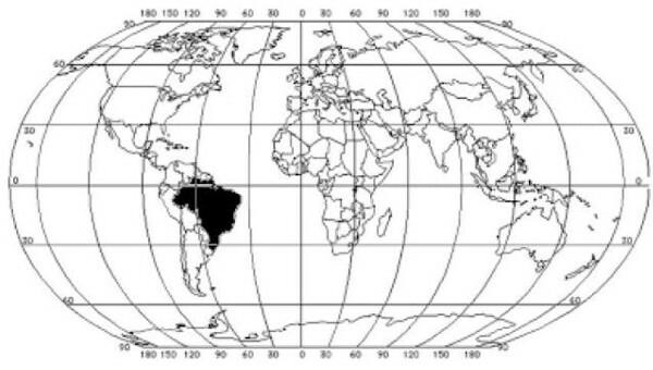
Adapted from Geography by Professor António Lobo. Available in: .
As for the geographic location of Brazil, it is CORRECT to state that
a) the country is located entirely in the western hemisphere.
b) the national territory is cut to the south by the Tropic of Cancer.
c) the entire country is in the southern hemisphere, south of the equator.
d) the country occupies the central-western portion of the South American continent.
e) the country is located in the intertropical climate zone.
Resolution:
Alternative a. Brazil is inserted in the West (Western Hemisphere), as it is to the left of the Greenwich Meridian.
________
question 2 - (Puc-PR) Regarding the variation of hours between different regions of the globe, check the INCORRECT alternative:
a) Time zones are limited by meridians.
b) The 15° range of time zones results from the latitude of the tropics.
c) The base time zone is that which contains the Greenwich Meridian.
d) The increase in hours to the east is a consequence of the Earth's direction of rotation.
e) The International Data Line cuts through the Pacific Ocean.
Resolution:
Alternative b. Time zones are calculated based on the distance in degrees from the Greenwich meridian. The meridians, in turn, define the longitudes. It is the parallels that define the latitudes.
_______
Question 3 - City A, located in the 75º East zone, wants to watch live an event that will take place in France at 4 pm. For this, what time should the residents of city A turn on their televisions?
a) 20 hours
b) 21 hours
c) 22 hours
d) 23 hours
it's midnight
Resolution:
Alternative b. To calculate the distance in hours from one location to another, we must pay attention to some details.
First step: identify whether hours will be decreased or increased. For this, it is enough to analyze the hemispheres of the places in question.
Second step: find the difference in hours. Dividing the value of degrees by 15 will have this difference: 75 / 15 = 5 hours.
Third step: add (or subtract) the time described. As the exercise says that city A is in the Eastern Hemisphere, and the reference is the Greenwich Meridian, the hours in this location are ahead. Thus: 16 + 5 = 21 hours.
By Attila Matthias
Geography teacher


