Known as Little Yugoslavia for synthesizing the diversity of the former Balkan nation, the Republic of Bosnia-Herzegovina makes limits with Croatia (to the north and west), Serbia (east) and Montenegro (to the southeast), in addition to having a tiny part of its territory washed by the sea Adriatic.
From 1992 to 1995, the country was the scene of the most violent conflicts of fragmentation of the Yugoslav territory. The clashes caused nearly 200,000 deaths and approximately 2.5 million refugees.
The Bosnian War began when Bosnia-Herzegovina declared its independence in 1992. The Serbs, opposed to the separation process, carried out ethnic persecution, expelling rival groups from areas under their occupation, in addition to carrying out massacres. Only in August 1995, the North Atlantic Treaty Organization (NATO) promoted intervention in the conflict by bombing Serbian positions. That same year, the bloodiest conflict on European soil since World War II came to an end.
The Dayton Agreement, signed in December, established the territorial limits of Bosnia-Herzegovina on its current borders. The state was divided into two entities: the Serbian Republic (49% of the territory) and the Bosnian Muslim-Croatian Federation (51%).
Bosnia-Herzegovina, together with Macedonia, is one of the economically poorest republics in the former Yugoslavia. The planned economy, in addition to the conflicts that took place in the country for years, destroying infrastructure, causing deaths and emigration flows, hampered national economic development. Another aggravating factor was the disruption of trade relations imposed by Serbia and Croatia.
The nation proclaimed its independence on September 1, 1992.
Do not stop now... There's more after the advertising ;)

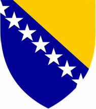
Bosnia-Herzegovina Coat of Arms
Bosnia-Herzegovina data:
Territorial extension: 51,129 km².
Location: Europe.
Capital: Sarajevo.
Climate: Temperate continental.
Government: Tripartite presidential republic, with one Bosnian Muslim, one Bosnian Croatian and one Bosnian Serb representative.
Administrative division: 100 districts.
Language: Bosnian.
Religion: Islam 60%, Christianity 35% (Orthodox 17.6%, Catholic 17.2%, others 0.2%), no religion and 5% atheism.
Population: 3,766,579 inhabitants. (Men: 1,812,338; Women: 1,954,241).
Ethnic Composition: Serbo-Croats 92.3%, other 7.7%.
Demographic density: 76 inhabitants/km².
Average annual population growth rate: 0.67%.
Population residing in urban areas: 48.02%.
Population residing in rural areas: 51.98%.
Undernourished population: 4%.
Life expectancy at birth: 74.6 years.
Households with access to clean water: 99%.
Households with access to a health network: 95%.
Human Development Index (HDI): 0.710 (high).
Currency: Convertible Mark.
Gross Domestic Product (GDP): US$ 14,771 million.
GDP per capita: 3,754 of US$.
External relations: World Bank, IMF, UN.
By Wagner de Cerqueira and Francisco
Graduated in Geography
Brazil School Team
countries - geography - Brazil School
Would you like to reference this text in a school or academic work? Look:
FRANCISCO, Wagner de Cerqueira and. "Bosnia Herzegovina "; Brazil School. Available in: https://brasilescola.uol.com.br/geografia/bosniaherzegovina.htm. Accessed on June 27, 2021.


