
You rivers are large reservoirs that contribute to the survival of life on Earth. They are unevenly distributed across the planet, which makes us think of their importance in the scenario world, considering that many societies travel miles to reach water candy. Thus, they must be preserved, being essential for life.
Read too: What are the flying rivers of the Amazon?
Components of rivers
To analyze a river and its use, it is necessary to know its parts in order to identify the use of that river. Rivers can be used for various activities: leisure, human consumption, transport, industrial supply, energy generation, among other actions. Thus, knowing the components of a river is essential to analyze the form and use of this reservoir.
See the components of a river and their respective characteristics.
Source (head): place where the river starts, always located at a higher point in the terrain.
Mouth (outlet): point where the river ends, usually discharging into the sea, lake or other river.
Course: path that the river runs from the source to the mouth.
Bed (channel): strip of land, below the neighboring areas, where the river flows.
margins: strips of dry land located on each side of the river bed.

types of rivers
Rivers can be classified in various ways, by size in territorial extension, by flow (amount of water in the river's course), or even by the type of water regime that feeds them. Let's analyze these last characteristics, because the way the river receives its waters it is fundamental for us to understand where it comes from and where it is going, as well as helping to understand water regimes and their use as a natural resource.
As for the types of rivers, we can classify them as follows:
riversNivals: they are supplied with snow thaw, especially at high altitudes.
riversglaciers: are supplied by glaciers and polar ice caps, through the natural melting of ice, and can be found in areas of extreme cold, such as the planet's poles.
riverspluvial: are supplied with rainwater, being the most common around the world.
riversperennials: are those that never dry up, that are permanent even during the dry season, like the São Francisco River.
riversflashing: are those that dry during the dry season. They are common in semiarid and arid areas, such as some rivers in northeastern Brazil.
Do not stop now... There's more after the advertising ;)
River characteristics
To understand rivers and their characteristics, it is necessary to understand the river hierarchy. It occurs according to the size of the river and its contribution to the hydrographic basin where it is located. We divide the river hierarchy into three orders:
first order: spring rivers, with low flow.
second order: rivers formed by the union of two rivers of the first order.
third order: rivers that form with the union of second order rivers.
This shows us that the greater the order of the river (third order, for example), greater will be your flow and its contribution within the river basin. Based on this, we can list some characteristics of rivers of the three orders, from the small streams, which serve for the food for the local population and irrigation of subsistence agriculture, to the great rivers such as the Nile River on the mainland African.
In general, third-order rivers are of great benefit to societies. Among the most common features, here are a few:
mighty rivers: they are extensive and with a large volume of water. Usually the watershed in which they are located bears their name, such as the ryo Amazons.
Plateau rivers: they are located in regions with rugged terrain and varying altitudes. They are great for energy generation and installation of hydroelectric plants, such as the Paraná River, in the sBrazilian southeast.
Plain rivers: its course is located in relatively flat areas. They are ideal for sailing and fishing, such as the Araguaia river, in the Çenter-OThis one of Brazil.
See too: Anthropogenic actions in the environment
Importance of river preservation
It is impossible for us to imagine life without water, as its use encompasses human and animal consumption, the development of agricultural and industrial activities, energy production, leisure, in short, countlessbenefits. With this, we realize that water is the most important natural resource we have on the planet, and its preservation is fundamental.
However, at all water available for consumption on the planet, only 0.4% it is easily accessible in rivers and lakes, not to mention the water in gaseous form in the atmosphere (clouds) that generates precipitation (rain).

This graph shows us, in a simple way, how necessary it is to preserve rivers and lakes around the world, as the amount available for consumption is very small compared to the whole. However, rivers are increasingly suffering from anthropogenic degradation, which is caused by humans. Unsustainable human activities have a very negative impact on nature, and rivers absorb this negativity.
Release of domestic sewage, industrial waste without proper treatment; deforestation of riparian forests that protect rivers; Power generation based on fossil fuels, causing acid rain, are some of the problems that rivers receive from human societies.

The United Nations (UN) launched, in the 1980s, the concept of sustainable development, to prevent actions, such as those mentioned, from causing irreversible damage to nature. For water consumption, the sustainable development can be applied in the following situations:
Rainwater collection: systems that collect rainwater can be built to use it in less complex activities, such as flushing toilets, irrigating gardens, maintaining agriculture, among others.
Protection of aquifers: aquifers are groundwater that feed on water that infiltrates the soil through porous rocks. These aquifers are contaminated with the use of pesticides on the surface, in addition to sewage dumped in inappropriate places and open-air dumps with leachate, the liquid that flows from the decomposition of garbage. Protecting aquifers is protecting the consumption of drinking water in the long term and the renewal of this important natural resource.
Environmental education: the population must be encouraged to protect the environment and everything in it, developing sustainable practices so that we can survive in harmony and without waste.
Main rivers in the world
Even though the amount of fresh water available for consumption is small, only 0.4% of the total, the water is constantly changing thanks to hydrological cycle. This cycle allows for an interaction between the amount of water in rivers and rational and sustainable consumption, causing the world's great rivers to continue with a large flow.
Let us now see, by continents, some of the main rivers in the world.
Europe
Rhine: is the most important river in Europe. It starts in Switzerland, in the Alps, and flows into the North Sea, running south-north. Its importance is due to its course, which passes through important German industrial centers, constituting an important European waterway linked to the Port of Rotterdam, in the Netherlands.

Danube: second largest European river in territorial extension. It is considered the most international river in Europe, as it crosses 10 countries. It starts in Germany and flows into the Black Sea, running north-south.
sena: French river, stage of beautiful Parisian landscapes, being a communication with the English Channel, its mouth. Born in the city of Source-Seine, south of Paris.
Volga: largest river in Europe. It starts in Russia and flows into the Caspian Sea, running north-south.
Asia
ganges: sacred river located in India. It influences the lives of approximately 300 million Indians, being important both in food and in religion (Hinduism).
Yan-Tse: the longest river in Asia and the third longest river in the world, the Yan-Tsé rises in the plateau of Tibet and has its mouth in China, running from west to east. It houses the largest hydroelectric power plant in the world, the Três Gargantas Power Plant.
America
Missouri: largest river in the United States. Its mouth is the Mississippi River, the second longest river in the country. Together they form a river system of nearly six thousand kilometers.
Africa
Nile: Running south-north, it is famous for civilizations that developed on its shores, such as the Egyptians. It is born in the mountains of Sudan, flowing into the Mediterranean Sea. It is the second largest river in the world in terms of flow.
Main rivers in Brazil
Brazil is the country that has the greatest water potential on the planet. This means that we have the largest amount of rivers, lakes and aquifers in the world available in our territory, making Brazilian soil strategic when it comes to water. It is estimated that 12% of the fresh water available for consumption is in Brazil.
However, despite this significant amount of water resources, the distribution is uneven, concentrating 68% of Brazilian waters in the North region, the region with the smallest demographic density from the country. This is reflected in long droughts in some Brazilian areas, such as in the North East, and water rationing in large urban centers during the dry season, such as in the state of São Paulo.
Let's see, by Brazilian regions, some of the most important rivers in Brazil:
Midwest
Araguaia: is the natural border between Mato Grosso and Goiás, running south-north, passing through Tocantins and Pará. It is considered the beach of Goiás, because, in winter, its flow decreases, forming beautiful beaches along its course.
North East
San Francisco: despite its source being located in Minas Gerais, in Serra da Canastra, the “old Chico”, as it is popularly known, it is extremely important for the regions of the northeastern hinterland for being a river perennial. Its mouth is also a natural border between Sergipe and Alagoas.
North
Amazonas: considered the largest river in the world in terms of flow, the Amazon River originates in Peru and is the most important in the country due to its presence in the Amazon Forest. In addition, it serves as transport for the riverside population due to the low number of roads in that region. Running west-east, its mouth is in the state of Pará, in the city of Belém.
Southeast and South
Paraná: considered the second longest river in Brazil, it starts in Mato Grosso do Sul and flows into the Rio da Prata, running north-south. Its highlight goes to the Itaipu Hydroelectric Power Plant, the second largest in the world. This plant feeds a large part of these two Brazilian regions, considered the richest in the country.
See too:States of Brazil: capitals, data, maps, list
solved exercises
Question 1 - (PUC-SP) Pay attention to the chart below:
THE DISTRIBUTION OF WATER ON THE SURFACE OF THE GLOBE
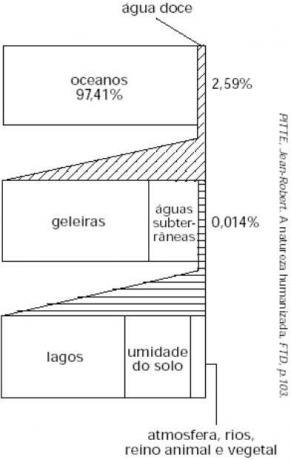
Then, also considering your knowledge of the issue of water on the planet, mark the alternative that correctly interprets the graph.
a) Freshwater stocks represent a tiny portion of the overall amount of water on the planet and, furthermore, their distribution is very uneven.
b) From the graph, it can be seen that most of the freshwater stock is present in natural lakes, the which facilitates the processes of uptake by the human being, in addition to making the treatment of the Water.
c) The graph shows that the freshwater stocks on the planet are huge compared to the total, the problem being that most of these stocks are frozen or in underground environments.
d) The insignificant amount of groundwater in the overall water cycle shows that it is worth facing the high costs for its extraction, as little results would be achieved. advantageous.
e) In the distribution of water on the planet, they represent the largest water supplies in the Earth's crust, in order of magnitude: oceans, glaciers, lakes and groundwater. Water vapor in the atmosphere represents the smallest part.
Resolution
Alternative A. The distribution of water on the planet is quite uneven, with regions well supplied and others living under water rationing, in addition to the fact that fresh water in the world does not reach 3% of all the water in the world.
Question 2 - (Fameca) Read the Dik Browne comic:

The rivers that have the characteristics pointed out by the characters can be found in places
a) of semi-arid tropical climate, as is the exclusive example of the São Francisco River, located in Brazil.
b) from a temperate continental climate, such as those found only in northern Canada.
c) of temperate oceanic climate, typical of the United Kingdom in all its extension.
d) equatorial and tropical climates, with rainfall that feeds their beds.
e) of cold climate, due to the definition of the four seasons of the year.
Resolution
Alternative B. Flowing rivers have great flow throughout the year, and many give names to the basins that shelter them. These rivers are most often found in areas where the precipitation rate is high, such as at low latitudes, in equatorial and tropical areas.
By Attila Matthias
Geography teacher
