Located in the west-central portion of the African continent, the territory of Congo is limited to the Central African Republic (to the north), Cameroon (to the northwest), Gabon (to the east), Angola (to the south, through Cabinda) and the Democratic Republic of Congo (to the south and west), in addition to being bathed by the Atlantic Ocean (the south-west).
The territory that currently corresponds to the Congo was inhabited by tribes of Pygmies and Bushmen. In the 16th century, the Portuguese tried to start the colonization process, however, the local groups resisted and did not allowed such an event, however, a significant slave trade was established during about 300 years old. At the end of the 19th century (1891), France used force and colonized the country, promoting a massacre of the population – it is estimated that more than 60% of the inhabitants were killed. National independence was only achieved on August 15, 1960. The colonization legacies are still present, especially in the official language: French.
The country is home to several ethnic groups, a fact that triggered a civil war during the 1990s, causing the deaths of more than 10,000 people. Most of the inhabitants live from agriculture and livestock, mainly subsistence. However, the economy's main source of revenue is the extraction of natural resources, especially diamond, copper, cobalt and oil, which account for 80% of exports.
According to data released in 2010 by the United Nations (UN), Congo has an average Human Development Index (HDI): 0.489. Among the social problems detected in the country are: 22% of the inhabitants are undernourished; the infant mortality rate is high: 79 for every thousand live births; the illiteracy rate is 19%; environmental sanitation services are intended for only 20% of homes.
Do not stop now... There's more after the advertising ;)

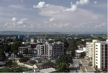
Brazzaville, capital of Congo
Congo data:
Territorial extension: 342,000 km².
Location: Africa.
Capital: Brazzaville.
Climate: Equatorial (to the north) and tropical (to the south).
Government: Presidential Republic.
Administrative division: 12 regions, 86 districts and 7 municipalities.
Languages: French (official), Quicongo, Lingala.
Religions: Christianity 89.6% (Catholics 49.7%, Protestants 11.2%, others 28.7%), traditional beliefs 5.1%, no religion and atheism 3.1%, others 2.2%.
Population: 3,683,182 inhabitants. (Men: 1,838,456; Women: 1,844,726).
Composition: Congos 48%, songos 20%, bateques 17%, embochis 12%, other 3%.
Demographic density: 10.7 inhab/km².
Average annual population growth rate: 2%.
Population residing in urban areas: 61.72%.
Population residing in rural areas: 38.28%.
Undernourished population: 22%.
Life expectancy at birth: 54.5 years.
Households with access to drinking water: 71%.
Households with access to a health network: 20%.
Human Development Index (HDI): 0.4489.
Currency: CFA Franc.
Gross Domestic Product (GDP): 10.7 billion dollars.
GDP per capita: $1,938.
External relations: World Bank, IMF, WTO, UN, AU.
By Wagner de Cerqueira and Francisco
Graduated in Geography
Brazil School Team
countries - geography - Brazil School


