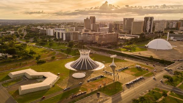
Brasilia is located in the Central Plateau and emerged after years of historical and geographic questions about the transfer of political power from the coast to the interior of the country, at some central point.
Founded in April 21, 1960, Brasília is the stage of intense transformations and full of diversities, both from an economic point of view, in relation to the distribution of income, and from a social point of view, when analyzing the population that includes the capital and its surroundings, in the regions administrative.
Read too: Populist Republic – historical moment when Brasília was built
Brasilia general data
- Gentile: brasiliense.
- Location: located in the Central Plateau, Central-West of Brazil, at 15°47’ south latitude and 47°56′ longitude.
- Parents: Brazil.
- Unitfederative: Federal District (DF).
- Regionmetropolitan: the metropolitan area of Brasília (AMB) is made up of eleven cities. They are: Águas Linda de Goiás, Alexânia, Cidade Ocidental, Cristalina, Formosa, Luziânia, Novo Gama, Padre Bernardo, Planaltina de Goiás, Santo Antônio do Descoberto and Valparaíso de Goiás. Knowing these cities is essential for urban planning in Brasília, as many inhabitants of these cities seek basic services (health, education, leisure) in the federal capital.
- Countiesborderline: Brasília is an area that was built to host the Federal Government, in the 1950s. With that, around it, there are the Administrative Regions (RAs), which are around the federal capital.
In total, there are 33 RAs:
RA I: Pilot Plan - Brasilia
RA II: gamma
RA III: Taguatinga
RA IV: Brazil
RA V: little house
RA VI: plateau
RA VII: paranoah
RA VIII: Bandeirante Nucleus
RA IX: ceilandia
RA X: Maned
RA XI: cruise
RA XII: fern
RA XIII: Santa Maria
RA XIV: San Sebastian
RA XV: Corner of Emus
RA XVI: south lake
RA XVII: deep River
RA XVIII: north lake
RA XIX: Candangoland
RA XX: Clear water
RA XXI: Deep Stream II
RA XXII: Southwest/Octagonal
RA XXIII: Varjão
RA XXIV: Park Way
RA XXV: SCIA
RA XXVI: Sobradinho II
RA XXVII: Botanical Garden
RA XXVIII: Itapoã
RA XXIX: SIA
RA XXX: Vincent Pires
RA XXXI: Fercal
RA XXXII: Rising Sun/Sunset
RA XXXIII: Arniqueira
The Federal District is bordered by some municipalities in Goiás and one in Minas Gerais. Are they:
- At North: Planaltina de Goiás, Father Bernardo and Formosa;
- South: Luziânia, Cristalina, Santo Antônio do Descoberto, Cidade Ocidental, Valparaíso and Novo Gama;
- East: Formosa and Cabeceira Grande (MG);
- To the west: Alexânia, Santo Antônio do Descoberto, Padre Bernardo and Águas Lindas.
Brasilia geography
See below some data about the federal capital. These data are based on surveys by the Brazilian Institute of Geography and Statistics, the IBGE. Within parentheses are the years of each survey.
- Demographic density: 444.66 inhabitants per km² (2010);
- Municipal Human Development Index: 0,824 (2010);
- Schooling (6 to 14 years): 97,5% (2010);
- Child mortality: 11.08 deaths per thousand live births (2017);
- GDP per capita (in reais): 80.502,47 (2017);
- Total vehicles: 1.812.473 (2018);
- Total area: 5,760,783 km² (2018);
- Total population: 3.015.258 (2019);
- Climate: tropical continental¹;
- Altitude: average of 1000 m above sea level²;
- Timezone: 45th west of Greenwich.
Comments:
- ¹Located at Midwest Brasilia is influenced by the climate that prevails in that region. This climate has two well-defined seasons, a summer rainy and one Winter dry. The average temperature in Brasília varies between 13ºC and 28ºC. this big thermal range it occurs due to the region's altitude, which can reach 1300 m above sea level. The rains are concentrated between October and April, the period when there is greater precipitation in the Center-West region of Brazil. However, there can be periods of three to five months without a drop of water falling in the region.
- ²The DF, which is on the Brazilian Central Plateau, has an altitude ranging from 800 to 1350 m above sea level. In this region, the existence of relatively high and flat reliefs, such as the chapadas, is very common. The highest peak is located in Serra do Sobradinho, with 1341 m of altitude, nicknamed Pico do Roncador.
Brief history of Brasilia
O settlement of the Central Plateau, for some historians, dates back to the 17th and 18th centuries, with the first flags, expeditions that penetrated the interior of Brazil in search of gold and precious stones. However, this occupation, in many cases, was temporary, not successfully achieving a solid population capable of developing the regional economy. *
the intention of transfer the country's capital to some inland area appeared at some historical moments. José Bonifácio – a political figure of great influence in the Brazilian Empire – and, before him, Marquis of Pombal, in the eighteenth century, were names that fueled this idea.

In 1956, with a land demarcated in the interior of Goiás, the then president of the Republic, Juscelino Kubitschek, forwarded to the National Congress the "Message from Annapolis", which proposed the name Brasília for the new capital, among other issues related to the construction of the city. In 1957, Lucio Costa's urban design was chosen as the winner among 26 eager competitors for the project to build the new capital. In 1957, Juscelino sanctioned the law that determined the foundation of Brasília three years later.
Foundation ofBrasilia
According to the law sanctioned by Juscelino, the foundation of Brasília was scheduled for April 21, 1960. Were 41 months of construction, with numerous buildings, highways, implementation of water and sewage services, in addition to the city's artificial lake, Lake Paranoá. To learn more about the construction of the new Brazilian capital, access our text: Construction of Brasilia.

Brasilia Demography
At the first year of construction of Brasilia, in 1957, there were 12,283|1| people living in Planaltina and on the outskirts of the region, the majority formed by immigrants attracted by the construction process of the new city. It is estimated that, in the 1960s, more than 90% of the population of Brasilia was composed of migrants.
This population, which came in search of work and opportunities, mainly in the public sector, shaped Brasília, which resulted in a mixture of accents, faces and colors. At the time, migrant workers were called “candangos”, a pejorative African term that means “bad” and alluded to the manual workers in the foundation of the capital.
According to the Federal District Planning Company (Codeplan), currently immigrants account for 51.9% of the population of the DF, being 26.5% from the Northeast Region and 14.4% from the Southeast Region.
Also according to the same agency, 29.3% of the population of the DF has incomplete primary education and only 15.9% have a higher education degree, including graduation, specialization, master's and/or doctorate.
See too: Darcy Ribeiro – founder and first rector of the University of Brasília
Brasilia Economy
As it is a geographically limited territory, the DF is unable to encourage the primary and secondary sectors of the economy (agriculture and industry, respectively).
until the 1990s, much of the DF economy and, consequently, Brasília revolved around the civil construction and small agricultural production for the domestic market. It was only from this period that the services and tourism sectors gained strength, configuring themselves, today, as the most important for the Gross Domestic Product Of region.
According to Codeplan, in 2012, the percentage of employees in the service sector was 69.11%, mostly in the Plano Piloto (47%). These numbers show the strength of services in Brasília, such as banks, universities, doctors' offices, information segment (pay TV, internet, cell phones), among others.
Codeplan, in partnership with IBGE, also reveals that 93% of the Gross Domestic Productof the DF is filled with the service sector. This data is reflected in GDP per capita region, which is the highest in Brazil.
Considered a World Heritage Site by UNESCO, Brasília has a very strong cultural and economic tourism. Many tourists visit the city for business, but also enjoy the city's cultural spaces. Due to strong tourism, the Ministry of Tourism classifies Brasília in category A, which reveals the large influx of tourists and the great employability in the hotel sector, driving the economy.
Brasilia culture
In 1987 Brasilia was considered Humanity's cultural heritage. Talking about culture in Brasília is talking about the city itself. Your modern architectural lines, inspired by Oscar Niemeyer's drawings, and the bold urbanization designed by Lúcio Costa make Brasília a full plate for those who want to know a planned and welcoming city.
Some historical monuments highlights such as Praça dos Três Poderes, the Metropolitan Cathedral of Brasília, the Candanga Memory Living Museum, the JK Museum, which tells the life of the city's founding president, and countless others.

O Brazilian rap and rock are also strong brands in Brasilia's culture. Nationally renowned artists emerged there, such as the Tribo da Periferia group and the national rock band Legião Urbana.
In addition, cinema also plays an important role. Annually occurs the Brasilia Festival of Brazilian Cinema, at Cine Brasília.
Read too: Material culture and immaterial culture - different types of cultural manifestations
Brasilia government
In the beginning, the DF was divided into eight administrative regions, each with a general administrator, who was appointed by the mayor. This way of governing prevailed until 1969, when the first governor of the DF was appointed by the president of the Republic.
O first governor was Hélio Prates da Silveira, remaining in the mandate for five years, from 1969 to 1974. Since then, the DF has already had 16 governors, with emphasis on Joaquim Domingos Roriz, who has governed the region four times, once by appointment of the President of the Republic and three in form democratic. Furthermore, he was the first democratically elected ruler in 1994.
Brasilia Infrastructure
According to the Federal District Environmental Sanitation Company (Caesb), a public company under private law that provides water and sanitation for the DF, Brasília is the administrative region that has the most households with access to basic sanitation and access to water supply. Water. Of the 86,583 occupied households, 86,338 have a water network and 86,387 have a sewage network.
All over the DF, more than 98% of households have a water supply by general network. However, this number drops if we analyze specific regions, such as Jardim Botânico, which has just over 89% of the water network.
Already sanitary sewage is treated in 87% of homes in the DF, which percentage is higher in the Plano Piloto. THE garbage collection, carried out by the Urban Cleaning Service of the Federal District, serves 96% of homes, data collected by the last District Household Sample Survey, carried out in 2011. All residents pay a public cleaning fee to maintain these services.
O access to health is regulated by the Health Department of the Federal District, which has 16 public hospitals, almost 4,000 beds, 65 health centers and 44 health posts spread across the DF.
Grades
|1| Data taken from the document Federal District in Summary – Socioeconomic and geographic information 2012. Brasília: Editora Codeplan, 2013, page 39.
By Attila Matthias
Geography teacher

