Honduras, or Republic of Honduras, is a country located in Central America. It borders the Caribbean Sea to the north, Nicaragua to the south, and El Salvador and the Gulf of Fonseca to the west. The country covers an area of 112,088 km2, where about 7.4 million inhabitants live, the official language is Spanish.

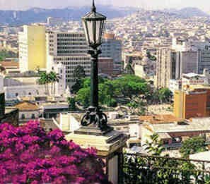
View of the Honduran capital, Tegucigalpa
Natural Aspects of Honduras
Relief: the surface irregularities of the territory are basically classified by four relief units: plain and eastern mountain slopes; to the north, floodplains and coastal mountain ranges, highlands in the center of the country and the plains of the Pacific and low slopes of the mountains. Among the countries of Central America, Honduras has the most mountainous territory. Altitudes throughout the territory range between 600 and 2,700 meters.
Vegetation: the typical vegetative composition of the country is tropical, including pine and oak forests. In restricted areas of the territory there are also patches of savannah.
Hydrography: the main river in Honduras is the Coco or Segovia, its length is 275 km, there are also important rivers such as the Patuca, Aguán, Ulúa, Sico, Choluteca; lagoons and lakes are identified, such as Lagoa de Caratasca and Lake Yojoa.
Economy: Honduras has the worst economic development rates among all Latin American countries. A large part of the country's income comes from agricultural activity, which makes about 4.8 million people work in this sector of the economy. The main agricultural products destined for export are: coffee, bananas and shrimp.
Do not stop now... There's more after the advertising ;)
By Eduardo de Freitas
Graduated in Geography
Brazil School Team

