Located on the African continent, more precisely in the region called Horn of Africa, the Djibouti limits itself with the Somalia (to the southeast), Eritrea (to the north) and Ethiopia (to the west), as well as being washed by the Indian Ocean (to the east). National independence was won on June 27, 1977, making it the last French colony in Africa to gain political autonomy.
Djibouti, whose land area is approximately 23.2 thousand square kilometers, is one of the hottest and arid countries in the world, harboring saltwater lakes in the interior of the territory. Another outstanding physical feature are the mountain ranges, which reach more than 1,600 meters in altitude.
The national population is made up of around 879 thousand inhabitants, of which 76% live in urban areas. Djibouti, the country's capital, is the most populous city, with 583,000 inhabitants. Most of the population faces several socioeconomic problems: the infant mortality rate is 80 per thousand live births; the illiteracy rate is 30%; and most live below the poverty line, that is, on less than $1.25 a day.
Djibouti's economy is underdeveloped, making the country one of the poorest on the planet. The soil and climate do not contribute to the practice of agricultural activities, and the country is obliged to import most of its food. Relations in the capital's port are the main source of financial income, in addition to investments from the United States of America (USA) and France.
Do not stop now... There's more after the advertising ;)

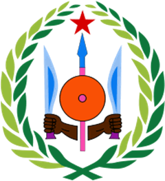
Coat of Arms of Djibouti
Djibouti data:
Territorial extension: 23,200 km².
Location: Africa.
Capital: Djibouti.
Climate: Arid tropical.
Government: Republic with mixed form of government.
Administrative division: 5 districts.
Languages: Arabic and French (official), Somali, Afar.
Religions: Islam 96.9%, others 1.9%, agnosticism and atheism 1.2%.
Population: 879,053 inhabitants. (Men: 439,364; Women: 439,689).
Demographic density: 38 inhab./km².
Average annual population growth rate: 1.7%.
Population residing in urban areas: 76.2%.
Population residing in rural areas: 23.8%.
Population with access to drinking water: 92%.
Population with access to sewage network: 56%.
Life expectancy at birth: 56.1 years.
Infant mortality rate: 80 for every thousand live births.
Human Development Index (HDI): 0.402 (low).
Currency: Djiboutian Franc.
Gross Domestic Product (GDP): 1 billion dollars.
GDP per capita: 1,076 dollars.
External relations: World Bank, IMF, WTO, UN, AU.
By Wagner de Cerqueira and Francisco
Graduated in Geography
Brazil School Team
Would you like to reference this text in a school or academic work? Look:
FRANCISCO, Wagner de Cerqueira e. "Djibouti"; Brazil School. Available in: https://brasilescola.uol.com.br/geografia/djibuti.htm. Accessed on June 27, 2021.


