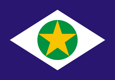
The State of Mato Grosso is located in the Brazilian Midwest region A capital is Cuiabá and the acronym MT.
- Area: 903,378,292
- Limits: north with Amazonas and Pará, east with Tocantins and Goiás, south with Mato Grosso do Sul, west with Bolivia and Rondônia
- Number of municipalities: 141
- Population: 3.2 million inhabitants
- Gentile: Mato Grosso
- Main cities: Cuiabá, Várzea Grande, Primavera do Leste
 Flag of the State of Mato Grosso
History
The colonization process of the territory now occupied by the State of Mato Grosso began in 1525. Portuguese Pedro Aleixo Garcia was responsible for the first expeditions to explore the site.
The very name of the state refers to the difficulty encountered by explorers. As the forest was thick, it was called Mato Grosso. The name was kept when the region was elevated to the status of captaincy in 1748.
The settlement in the region was boosted with the discovery of gold. The highlight was for the Portuguese who did not respect the Treaty of Tordesillas, whose agreement kept the territory in possession of the Spaniards.
The borders were redefined by the Treaty of Madrid, signed in 1750, and Santo Ildefonso, in 1777. Under the agreements, the region came under the ownership of the Portuguese Crown.
Mato Grosso Division
The territory of Mato Grosso was divided in 1977, with the creation of the State of Mato Grosso, whose capital is Campo Grande and the acronym MS.
Separatist movements, however, are old. The first separatist uprising took place in 1892, still under Floriano Peixoto's government, but it was not successful.
Disputes between the southern and northern portions were so intense that the federal government had to intervene in 1917. The dismemberment, however, occurred after a series of agreements and considered the extension of Mato Grosso, too high and difficult to manage to happen.
read more:
- Midwestern States
- Midwest region
- Brazilian Regions
- State of Mato Grosso do Sul
- Brazil states
- Acronyms of Brazilian States
Economic Aspects
The state is among the main beef cattle producers in Brazil. Its production alternates with São Paulo and Mato Grosso do Sul. The region is also an imposing agribusiness center, with an emphasis on the planting of soy, corn, cotton, sugarcane and inputs for transformation into biodiesel.
Mato Grosso's economy is also fueled by tourism. Thousands of people are attracted to the Pantanal and the Chapada dos Guimarães region. In this location, at least 200 waterfalls are available for visitation.
Read more: What is Agribusiness.
Cultural aspects
Mato Grosso's culture is a mix of indigenous, black, as well as Portuguese and Spanish immigrants.
The mixture is perceived in the music, like the caruru, danced to the sound of the trough viola, ganzá and mocho. Siriri and Rasqueado are typical of the state. All rhythms result from a mixture of indigenous, African and Iberian sounds.
The same pattern of influence is followed by gastronomy. Typical of the state are roasted pacu with farofa and cabbage, farofa with plantain and rice with dried meat.
Mato Grosso Indians
In Mato Grosso live representatives of 59 indigenous peoples. They are representatives of the Tupi and Macro-Jê linguistic trunks.
The largest indigenous park in the country is located in Mato Grosso, the Xingu Indigenous Park, with 2,600 hectares. The site was created in 1961 and covers ten municipalities.
know more:
- Brazilian Indians
- Tupi-Guarani Culture
- Indigenous Culture
- Midwest Culture
Geographical Aspects
Relief
The Mato Grosso relief is dominated by plateaus, plains and plateaus. The composition integrates one of the most beautiful landscapes in South America.
Much of the Pantanal, the largest flooded plain in the world, is in Mato Grosso.
Climate
The Mato Grosso climate is semi-humid tropical. Temperatures vary between 23º and 26º C throughout the year, but can reach 40º C in summer. Winters are dry, with the relative humidity of the air being around 10%.
Hydrography
Two hydrographic basins are located in the state. The Amazon basin and the Tocantins basin. The main rivers are: Juruena, Teles Pires, Xingu, Araguaia, Paraguay, São Lourenço, Piquiri, Cuiabá and Rio das Mortes.
Also learn about other topics related to the topic.:
- wetland
- Pantanal Animals
- Brazilian Biomes
- thick
- Guarani Aquifer


