Periplus is a circumnavigation activity in which a round trip is made around a specific island, country, continent or territory. It is also the written record (cartographic or textual) of this trip, and many of these documents have passed through history, reaching the present day.
Read too: Pero Lopes de Sousa's navigation diary — document that narrates Martim Afonso de Sousa's expedition
Summary about tour
Periplus is a circumnavigation trip around a country, continent or territory, in a round trip direction, and the written record (cartographic or textual) of this.
In modern history, the most famous journey is the African one.
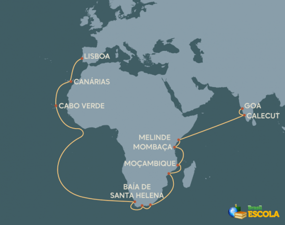
Part of the project of the Great Portuguese Navigations of the 15th and 16th centuries, the African Periplus aimed to bypass Africa and reach India by sea.
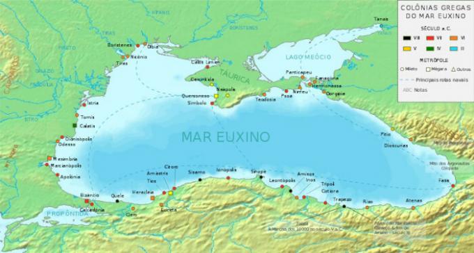
Throughout history, several tour navigation projects have existed, such as the Periplus of Pseudo-Sylax, who studied the Mediterranean Sea region, and Periplus of Pontus Euxine, who studied the region of the Black Sea.
What is periplus?
Periplus is a term used in different situations, in its literal and metaphorical sense. Literally, it is a circumnavigation trip, around a country, continent or other territory, which is expected to occur in a round-trip direction. Metaphorically, it can be a long-term tourist trip, a written or told account of these trips or even a long analytical or argumentative journey about a research topic.
Etymologically, the word derives from Greek, with the original meaning of circumnavigation. At the time of Greek navigation, which occurred as a result of diasporas and wars, notably those of the 5th and 4th centuries BC. C., it was common to produce a handwritten document that listed the places in which it was possible to moor vessels, the best geographical points along the coast and even warnings of dangers.
African tour

During the period of Great Navigation (15th and 16th centuries), Portugal, in its mission to find an alternative Atlantic route to India, needed to bypass Africa. As the dimensions of the African territory were unknown to him, it was necessary to carry out navigation and cartography: from expeditions, mapping the territory, listing safe ports and possible setbacks that navigators could find. This whole activity is a journey. Therefore, the African Periplus is defined by historians as the Portuguese process of navigation, knowledge and cartography of the African continent.
Therefore, the African Periplus receives its name from its literal meanings, as it involves the circumnavigation of the continent and the production of cartographic intelligence. Started in 1415 with the conquest of the then Muslim city of Ceuta, the project had as landmarks the travels of Bartolomeu Diasand Vasco da Gama. Bartolomeu Dias, in 1488, sailed around the Cape of Good Hope. Vasco da Gama completed the journey in 1498 and actually arrived in Calicut, India.
See too: Pero Vaz de Caminha — clerk responsible for the letter that announced the “discovery” of Brazil to Portugal
Examples of other tours

Throughout history, several other circumnavigations took place, for which cartographic documents were also produced. As an example of other journeys, the following can be listed:
Periplus of Hanno, in which the Carthaginian navigator of the same name explored and described the coast of present-day Morocco in the 6th century BC. W.;
Periplus of Pseudo-Sylax, Greek document from the end of the 4th century BC. W. which describes navigation conditions in the Mediterranean Sea region;
Periplus of Ponto Euxino, document that describes navigation and trade routes in the Black Sea region, produced at the beginning of the 2nd century.
Image credit
[1] George Tsiagalakis/Wikimedia Commons (reproduction)
Sources
CARVALHO, M. S. Terrae (in) cognitae. Geographic Magazine, v. 3, no. extra 1, p. 126-134, 2013. Available in: https://dialnet.unirioja.es/servlet/articulo? code=4735019.
PAULA, E. S. Some aspects of the West's relations with the Far East during Antiquity and the Middle Ages. History Magazine, v. 21, no. 43, p. 3-14, 1960. Available in: https://www.revistas.usp.br/revhistoria/article/view/120095.
PINTO, O. L. v. Between Egypt and Azania: Afro-Asian Connections from the Erythraean Sea Periplus. Mare Nostrum, v. 13, no. 1, 123-145, 2022. Available in: https://www.revistas.usp.br/marenostrum/article/view/198674.
SANTOS, A. A tour of double territory. Investigations Magazine, v. 22, no. 1, p. 51-101, 2009. Available in: https://periodicos.ufpe.br/revistas/index.php/INV/article/view/1362.


