
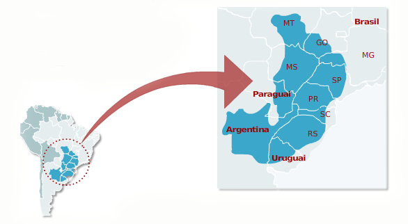
O Guarani Aquifer is an immense natural reservoir of water that is located in South America. Its area of 1.2 million square kilometers covers Brazil, Argentina, Paraguay and Uruguay. However, around 70% of this aquifer falls within Brazilian limits, where it comprises eight states and three different regions.
Formed in sandstone rocks and confined by a layer of basalt, the Guarani Aquifer contains 33 thousand km³ in volume of good quality water that supplies hundreds of cities in Brazil. Still, it faces serious problems such as pollution and the inadequate management of its waters.
Read too: São Francisco River — where it originates, its importance, everything about its transposition
Summary about Guarani Aquifer
Guarani Aquifer is a natural underground water reservoir that extends across part of the Center-West, Southeast and South of Brazil, and also covers areas in Argentina, Uruguay and Paraguay.
It formed from the storage of water in sandstone rocks, which are porous rocks.
As it is a confined aquifer, the sandstone rocks have a layer of basalt over them.
It is recharged in outcrop areas or through fractures in the basalt rock.
It covers an area of almost 1.2 million square kilometers, of which 70% is located in Brazil. The largest extensions of the Guarani Aquifer are found in Mato Grosso do Sul and São Paulo.
Hundreds of cities are supplied by the Guarani Aquifer, partially or completely.
There are cases, such as Ribeirão Preto, in which all water resources used in the municipality originate from this reservoir.
It is important for providing water for homes and for the development of economic activities such as agriculture and industrial production.
Water pollution is the main problem faced in the Guarani Aquifer.
Its main advantages are the large volume and good quality of water, while its disadvantages are exploration costs.
What is the Guarani Aquifer?
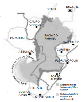
The Guarani Aquifer It's an underground springand cross-borderwhich stores a very large volume of water sweet underground. It is, therefore, an immense water reserve that extends across part of the Central-West, Southeast and South regions of Brazil, also covering areas in Argentina, Uruguay and Paraguay. It is also called the Guarani Aquifer System (SAG), being considered one of the largest and most important aquifers in the world.
How the Guarani Aquifer was formed
Aquifers, in general, are formed from the penetration of water on rocks porous cells that remain in the subsurface. It was no different with the Guarani Aquifer. This water reservoir developed in an area formed by sandstone rocks, whose sedimentation process began at least 250 million years ago in the geological past. The reservoir in question was constituted in two geological provinces of sandstone rocks known as the Piramboia Formation and the Botucatu Formation.
During the geological period known as the Cretaceous, several episodes of volcanismwhere today is the central portion of Brazilian territory resulted in lava spills over the area where the sandstone rocks were. After cooling, this lava turned into the basalt rock layer responsible for confining the Guarani Aquifer below the soil surface. Nowadays, the waters of the Guarani Aquifer are recharged through fractures in the rocks or in those areas where the aquifer waters appear on the surface, called outcrops.

Main characteristics of the Guarani Aquifer
The Guarani Aquifer is an underground water reserve that extends over an area of 1,195,500 km², covering four different countries in America southern. In the following table, find out the area of the aquifer that corresponds to each of these countries:
Country |
Guarani Aquifer Area |
Portion of the total area of the Guarani Aquifer |
Brazil |
839,800 km² |
70,2% |
Argentina |
225,500 km² |
18,8% |
Paraguay |
71,700 km² |
5,9% |
Uruguay |
58,500 km² |
4,8% |
As the data indicates, The largest area of the Guarani Aquifer is located in Brazil. In national territory, this immense underground reserve is arranged between eight states from three different regions. See how the waters of the Guarani Aquifer are distributed in Brazil:
state |
Guarani Aquifer Area |
Portion of the Brazilian area of the Guarani Aquifer |
Goiás |
55,000 km² |
6,5% |
Mato Grosso do Sul |
213,500 km² |
25,4% |
Mato Grosso |
26,400 km² |
3,1% |
Minas Gerais |
51,300 km² |
6,1% |
São Paulo |
155,800 km² |
18,5% |
Paraná |
131,300 km² |
15,6% |
Santa Catarina |
49,200 km² |
5,8% |
Rio Grande do Sul |
157,600 km² |
18,7% |
The state of Mato Grosso do Sul is the one that concentrates most of the waters of the Guarani Aquifer, more precisely a quarter of the entire extension of this reservoir. Next are Rio Grande do Sul and the state of São Paulo.
The Guarani Aquifer contains approximately 33,051 km³ of water stored underground. The maximum limit that can be removed without compromising the maintenance of this aquifer is 40 km³ of water per year, being this volume used to supply urban centers that depend partially or entirely on waters originating from the Aquifer Guarani.
The depth at which the Guarani Aquifer is depends largely on the area considered. In many places, as we have seen, its waters appear on the surface of the soil, which are called outcrops. In others, the waters of this reservoir can be up to 1,500 meters deep. The width of the water layer corresponding to the aquifer, in turn, varies between 200 and 800 meters.
See too:Water table — a type of natural aquifer
Cities supplied by the Guarani Aquifer
Hundreds of cities Brazilian They partially or totally depend on the Guarani Aquifer for urban water supply, directing this resource to homes and commercial establishments. Ribeirão Preto, Matão and Sertãozinho, which are cities in the interior of São Paulo, are examples of cities that depend 100% on the Guarani Aquifer to meet urban demand for this resource.
Other municipalities in São Paulo, such as Franca, São José do Rio Preto, Bauru and São Carlos, are partially supplied by this source. In total, 200 cities in São Paulo are supplied by the Guarani Aquifer. In addition to these, there are urban areas in all states where this water system is present and which are fully or partially served by it.

How important is the Guarani Aquifer?
The Guarani Aquifer It is the largest underground water reservoir in South America, and its importance lies in the fact that it supplies some of the regions with the highest population concentration in Brazilian territory. The resource that is obtained from this reservoir supplies homes and assists in the development of economic activitiesfrom all sectors: agriculture, industry and commerce.
There is also a strategic nature of the Guarani Aquifer, whose waters have high quality and high potential for use. Present in more than one country in South America, there is a project in vogue, which has the support of the World Bank, which studies the waters of the Guarani Aquifer for the implementation of future actions aimed at implementing new infrastructure that will guarantee greater access to this important water resource in the region.
Environmental problems of the Guarani Aquifer
A water pollution is the main environmental problem faced in the Guarani Aquifer. This problem, which happens together with soil pollution, é arising from inappropriate use of substrate and management improper of trash from cities and industrial and urban waste, such as sewage and waste resulting from production. As the aquifer covers a huge agricultural area in the country, residues from agricultural activities, such as pesticides and artificial fertilizers that percolate into the soil can also cause degradation in waters.
These polluting agents are discarded directly into the soil, into rivers or streams that are in the recharge area of the Guarani Aquifer, which ends up introducing polluting elements into the reservoir. In this sense, there is a degradation in the quality of its waters.
Know more:Siltation — a problem that affects rivers and could even lead to their extinction
Advantages and disadvantages of the Guarani Aquifer
Advantages of the Guarani Aquifer: It is a very large reservoir with a large supply capacity, with good quality water that makes it easier the treatment process preceding distribution. Furthermore, being an aquifer confined by basalt rocks, the risk of contamination and direct water pollution is much lower.
Disadvantages of the Guarani Aquifer: The depth in which its waters are found in certain locations and the presence of the basalt layer overlapping makes the process of exploring and removing water more costly in financial terms, as well as difficult. Inadequate management of this basalt rock and the intensive exploitation of the Guarani Aquifer can, in addition, cause problems in the structure of the rock and the soil that covers it.
Solved exercises on Guarani Aquifer
Question 1
(ENEM) The Guarani Aquifer, a mega underground water reservoir in South America, with 1.2 million km², is not the "freshwater sea" that was thought to exist. While in some areas the water is excellent, in others it is inaccessible, scarce or not drinkable. The aquifer can be divided into four large compartments. In the West compartment, there are good structural conditions that provide rapid recharge from rain and the water is, in general, of good quality and drinkable. In the North-Upper Uruguay compartment, the system is covered by volcanic rocks, at depths ranging from 350 m to 1,200 m. Its waters are very old, dating back to the Mesozoic Era, and are not drinkable in a large part of the area, with high salinity, and the high levels of fluoride and sodium can cause alkalinization of the ground.
Scientific American Brasil, no. 47, April/2006 (with adaptations).
In relation to the Guarani Aquifer, it is correct to state that:
a) its deposits do not participate in the water cycle.
b) waters from any of its compartments solidify at 0 °C.
c) it is necessary, to use its potential as a reservoir of drinking water, to know the aquifer in detail.
d) water is suitable for direct human consumption in a large part of the North-Upper Uruguay compartment area.
d) the use of water from the North-Upper Uruguay compartment for irrigation would make the soil acidic.
Resolution: Alternative C. Being a large and complex system, it is necessary to know the area to be explored very well and draw up appropriate action plans with the aspects of the section from which you want to collect water.
Question 2
(FUVEST) The Guarani Aquifer System covers part of the territories of Argentina, Brazil, Paraguay and Uruguay. It has an accumulated volume of 37,000 km³ and an estimated area of 1,087,000 km². In the Brazilian part, it extends across eight states: Goiás, Mato Grosso, Mato Grosso do Sul, Minas Gerais, Paraná, Rio Grande do Sul, Santa Catarina and São Paulo.
Available in https://www.mma.gov.br/.
Regarding aquifers and their uses for human activities, it is correct to state:
a) They occur in geological formations that contain water in significant quantities that move within them in natural conditions, allowing its use for public supply and tourist resorts of mineral waters and have more.
b) They consist of surface water reservoirs formed from volcanism and tectonism processes in areas of intense seismic activity; its flows can be used to produce geothermal energy obtained through heat from the interior of planet Earth.
c) Aquifers have a volume of proportions, however treatment costs make their use by human activities unfeasible, limiting them to animal watering.
d) Aquifers are formed by the action of winds that accumulate sand on the surface, facilitating the infiltration and accumulation of water in deeper layers; its uses for human activities depend on the excavation of very deep wells using technology unavailable in the country.
e) The aquifers are at depths that make their use for human activities impossible, including those intended for less noble purposes, such as washing sidewalks and squares.
Resolution: Alternative A. Aquifers such as the Guarani Aquifer are naturally formed in rocks with water storage capacity. In them, water can move normally, making it possible to extract this resource for urban supply and for use in various economic activities.
Image credits
[1]Wikimedia Commons
Sources
NATIONAL WATER AGENCY. Guarani Aquifer System. YouTube, 2020. Available in: https://youtu.be/embTw1Rq5DI.
CÂNDIDO, Keila. Guarani Aquifer, the underground giant. FUNDAJ, 01 Oct. 2020. Available in: https://www.gov.br/fundaj/pt-br/destaques/observa-fundaj-itens/observa-fundaj/revitalizacao-de-bacias/aquifero-guarani-o-gigante-subterraneo.
FELLET, John. With waters up to 250,000 years old, the Guarani Aquifer gains weight in supplying cities. BBC News Brasil, 04 April. 2022. Available in: https://www.bbc.com/portuguese/brasil-60962619.
FOSTER, S.; HIRATA, R.; SCHMIDT, G.; GARDUÑO, H. The Guarani Aquifer System Program Initiative – Towards Practical Groundwater Management in a Transboundary Context. In S. Foster; K. Kemper. (Eds.) GWMATE – World Bank. Case Profile Collection. 3The ed., vol. 9, 2009, pp. 1-28. Available in: https://documents1.worldbank.org/curated/pt/493231468055456938/pdf/388090PORTUGES0ATE0Portuguese0CP009.pdf.
GOMES, M. A. F. Agricultural use of the outcrop areas of the Guarani Aquifer in Brazil: implications for groundwater and management proposals with an agro-environmental focus. Brasília, DF: Embrapa Information Technology, 2008, 417p. Available in: https://www.embrapa.br/busca-de-publicacoes/-/publicacao/15642/uso-agricola-das-areas-de-afloramento-do-aquifero-guarani-no-brasil-implicacoes-para-a-agua-subterranea-e-propostas-de-gestao-com-enfoque-agroambiental.
GIANT GUARANI. Guarani Aquifer. Available in: https://giganteguarani.org.br/aquifero-guarani/


