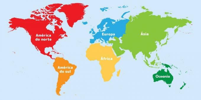
The world map is a graphic representation of the Earth, which shows the geographic location of continents, countries, oceans and other natural elements.
It is the map that reproduces the entire planet in a flat surface, that is, in a single image. It can be of different types of projections or styles.
Because it portrays the Earth, which is round, in a two-dimensional (2D) plane, the world map often has the shape and size of some regions distorted. However, the most recent maps already greatly minimize these distortions.
The name world map comes from Latin, in which mappa is a cloth or towel, and world (with the plural world) means world or universe.
See the world map:

Continents on the world map

Continents are large land areas separated by oceans, where countries, cities, mountains and forests, among others, are located. They exist six continents on planet Earth:
- Africa - is 30,370,000 km² long. It is a gigantic continent, with 54 countries. Very rich both culturally and in its biodiversity. It has tropical forests, mountains, plateaus, savannas and deserts, such as the famous Sahara Desert;
- America - has an area of 42,550,000 km². It is a continent that almost goes from one end of the planet to the other. It is divided into North America, Central America and South America. It has 35 countries;
- Antarctica - has 13,660,000 km². It is an ice-covered continent that lies south of South America and goes all the way to the South Pole. It has no countries thanks to the Antarctic Treaty, which established that the region would be free from territorial disputes, being used for scientific research;
- Asia - is 44,580,000 km² long. It is the largest continent and also the most populous. It has 49 countries, many of which are considered emerging. It has a diversity of climates and biodiversity, the Himalayas, for example, are in Asia;
- Europe - has 10,530,000 km². Called the old continent, it is recognized for its historical and architectural heritage, in addition to its high rates of human development. It has 51 countries, including the Vatican.
- Oceania - has an area of 8,526,000 km². With 15 countries, it is a region with a strong maritime culture, made up mainly of beautiful islands and archipelagos.
Countries on the world map
Countries are political and geographical units, managed by the same government, with their own organization, delimited territory, as well as specific population and culture. The total number of countries varies between 193 and 206.
This variation occurs because the recognition of a territory as a country needs to meet a series of requirements and be approved by the international community, which makes this recognition according to its interest. Therefore, some countries may recognize another as such, but other countries may not.
African countries and capitals
| Country | capital | Country | capital |
|---|---|---|---|
| South Africa | Cape Town | Madagascar | Antananarivo |
| Angola | Luanda | Malawi | Lilongwe |
| Algeria | Algiers | Mali | Bamako |
| Benin | Porto Novo | Morocco | Rabat |
| Botswana | Gaborone | Mauritius | Port Louis |
| Burkina Faso | Ouagadougou | Mauritania | Nouakchott |
| Burundi | Bujumbura | Mozambique | Maputo |
| Cape Green | Beach | Namibia | Windhoek |
| Cameroon | Yaoundé | Niger | Niamey |
| Chad | Jamena | Nigeria | Abuja |
| Comoros | Moroni | Kenya | Nairobi |
| Congo | Brazzaville | Central African Republic | Bangui |
| Costa do Marfim | Yamoussoukro | Democratic Republic of Congo | Kinshasa |
| Djibouti | Djibouti | Rwanda | Kigali |
| Egypt | Cairo | Sao Tome and Principe | Saint Thomas |
| Eritrea | Asmara | Senegal | Dakar |
| Eswatini | Lobamba and Mebabane | Seychelles | Victoria |
| Ethiopia | Addis Ababa | Sierra Leone | Freetown |
| Gabon | Libreville | Somalia | Mogadishu |
| Gambia | Banjul | Sudan | Khartoum |
| Ghana | Accra | Southern Sudan | Mane |
| Guinea | Conakry | Tanzania | Dodoma |
| Guinea Bissau | Bissau | Togo | Lomé |
| Equatorial Guinea | Malabo | Tunisia | Tunis |
| Lesotho | Maseru | Uganda | Kampala |
| Liberia | Monrovia | Zambia | Lusaka |
| Libya | Tripoli | Zimbabwe | Harare |
Countries and capitals of America
North America
| Countries | Capitals |
|---|---|
| Canada | Ottawa |
| U.S | Washington, D.C. |
| Mexico | Mexico City |
Central America
| Countries | Capitals | Countries | Capitals |
|---|---|---|---|
| Antigua and Barbuda | Saint John's | Haiti | Port Prince |
| Bahamas | Nassau | Honduras | Tegucigalpa |
| Barbados | Bridgetown | Jamaica | Kingston |
| Belize | Belmopan | Nicaragua | Managua |
| Costa Rica | San José | Panama | Panama City |
| Cuba | Havana | Dominican Republic | Santo Domingo |
| Dominica | Roseau | Saint Lucia | Castries |
| El Salvador | San Salvador | Saint Kitts and Nevis | Basseterre |
| Grenade | Saint Georges | Saint Vincent and the Grenadines | Kingstown |
| Guatemala | Guatemala City | Trinidad and Tobago | Port of Spain |
South America
| Countries | Capitals | Countries | Capitals |
|---|---|---|---|
| Argentina | Buenos Aires | Guyana | Georgetown |
| Bolivia | La Paz and Sucre | Paraguay | Asuncion |
| Brazil | Brasilia | Peru | lime |
| Chile | Santiago | Suriname | Paramaribo |
| Colombia | Bogotá | Uruguay | Montevideo |
| Ecuador | Quito | Venezuela | Caracas |
French Guiana, also located in South America, is a territory that belongs to France, and is also part of the European Union.
Countries and capitals in Asia
| Country | capital | Country | capital |
|---|---|---|---|
| Afghanistan | Kabul | Jordan | Love |
| Saudi Arabia | Riyadh | Kuwait | Kuwait City |
| Armenia | Yerevan | Laos | Vientiane |
| Azerbaijan* | Baku | Lebanon | Beirut |
| Bahrain | Manama | Malaysia | Kuala Lumpur |
| Bangladesh | Dhaka | Maldives | Male |
| Brunei | Bandar Seri Begawan | Myanmar | Naypyidaw |
| Bhutan | Possum | Mongolia | Ulan Bator |
| Cambodia | Phnom Penh | Nepal | Kathmandu |
| Qatar | Doha | Oman | Peddler |
| Kazakhstan | Nursultan | Pakistan | Islamabad |
| China | Beijing | Kyrgyzstan | Bishkek |
| Cyprus | Nicosia | Russia | Moscow |
| North Korea | Pyongyang | Singapore | Singapore |
| South Korea | Seoul | Syria | Damascus |
| United Arab Emirates | Abu Dhabi | Sri Lanka | Columbus |
| Philippines | Manila | Tajikistan | Dushanbe |
| Georgia | Tbilisi | Thailand | Bangkok |
| Yemen | Sana'a | Taiwan | Taipei |
| India | New Delhi | East Timor | Dili |
| Indonesia | Jakarta | Turkmenistan | Ashgabat |
| Will | Tehran | Türkiye* | Ankara |
| Iraq | Baghdad | Uzbekistan | Tashkent |
| Israel | Tel Aviv | Vietnam | Hanoi |
| Japan | Tokyo |
Taiwan is a region located in China, some countries recognize its existence as a nation, others do not. Brazil, for example, does not recognize Taiwan as an independent country.
The Asian and European continents border each other, and there are countries with their territory in both geographic areas, they are: Azerbaijan, Cyprus, Georgia, Russia and Turkey.
There are also Armenia and Kazakhstan, which are Asian, but are so close to Europe that they are also often considered old world.
European countries
| Countries | Capitals | Countries | Capitals |
|---|---|---|---|
| Albania | Tirana | Italy | Pomegranate |
| Germany | Berlin | Latvia | Riga |
| Andorra | Andorra la Vella | Liechtenstein | Vaduz |
| Austria | Vienna | Lithuania | Vilnius |
| Azerbaijan | Baku | Luxembourg | Luxembourg |
| Belgium | Brussels | North Macedonia | Skopje |
| Belarus | Minsk | Malta | Valletta |
| Bosnia and Herzegovina | Sarajevo | Moldavia | Quixinau |
| Bulgaria | Sofia | Monaco | Monaco |
| Cyprus | Nicosia | Montenegro | Podgorica |
| Croatia | Zagreb | Norway | Oslo |
| Denmark | Copenhagen | Wales | Cardiff |
| Scotland | Edinburgh | Netherlands | Amsterdam |
| Slovakia | Bratislava | Poland | Warsaw |
| Slovenia | Ljubljana | Portugal | Lisbon |
| Spain | Madrid | Czech republic | Prague |
| Estonia | Tallinn | Romania | Bucharest |
| Finland | Helsinki | Russia | Moscow |
| France | Paris | San Marino | San Marino |
| Georgia | Tbilisi | Serbia | Belgrade |
| Greece | Athens | Sweden | Stockholm |
| Hungary | Budapest | Switzerland | Bern |
| England | London | Türkiye | Ankara |
| Ireland | Dublin | Ukraine | Kiev |
| northern Ireland | Belfast | Vatican | Vatican CITY |
| Iceland | Reykjavik |
Oceania countries
| Countries | Capitals | Countries | Capitals |
|---|---|---|---|
| Australia | Canberra | New Zealand | Wellington |
| Fiji | Suva | Palau | Ngerulmud |
| Marshall Islands | Majuro | Papua New Guinea | Port Moresby |
| Solomon Islands | Honiara | Samoa | The washbasin |
| Kiribati | Tarawa | Tonga | Nucualofa |
| Micronesia | Palikir | Tuvalu | Funafuti |
| Nauru | Yaren | Vanuatu | Port Vila |
| Niue | Alofi |
Oceans on the world map
Most of the Earth's surface is made up of water, located in the oceans. There are 5 oceans in total:
- Atlantic Ocean - lies between America, Africa and Europe. It is approximately 106,000,000 km² long and 8600 m deep at its deepest point;
- Indian Ocean - is located between Africa, Asia and Oceania. It is approximately 70,560,000 km² in area and 7,250 m deep in its deepest part;
- Pacific Ocean - it is the largest ocean, it is between Asia, Oceania and the west coast of America. It is approximately 165,200,000 km² and 11,000 m deep at its deepest point;
- Arctic Glacier - is located in the extreme north of the planet, close to the North Pole. It is approximately 14,060,000 km² in area and 5,450 m deep in the deepest area, it is the smallest ocean;
- Antarctic Glacier - is located in the extreme south of the planet, in the South Pole region. It is approximately 20,330,000 km² long and 7,236 m deep at its deepest part.
Parallels and Meridians

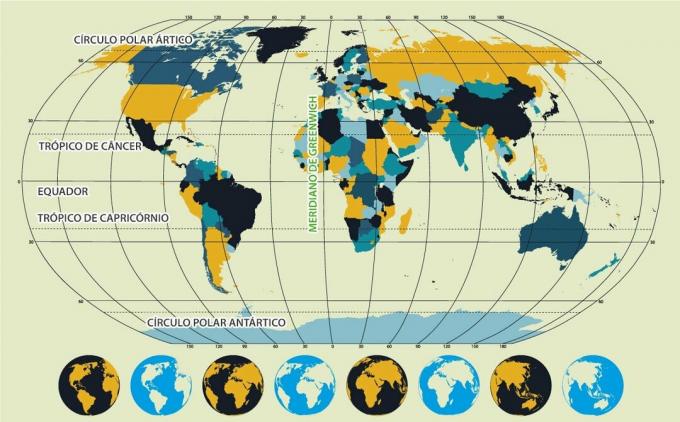
Parallels and meridians are imaginary lines created to assist in locating specific points on the earth's surface. Parallels are horizontal lines. Meridians are vertical lines.
The parallels identify the latitude (which goes from 0º to 90°, from the Equator to the poles) and the meridians, the longitude (ranging from 0° to 180° east to west from Greenwich).
Discover the main parallels and meridians:
- Greenwich Mean - passes through the city of London and marks 0° longitude;
- Equator Line - passes through the Equator, it is the line that marks 0° latitude, dividing the world into North and South;
- Arctic Circle - is a parallel located in the extreme north of the planet, at 66º33' N;
- Tropic of Cancer - this is a parallel located at 23º27' North;
- Tropic of Capricorn - is the parallel located at 23º27' South;
- Antarctic Circle - is the parallel that is approximately 66º33' South.
Learn more about parallels and meridians.
Other types of world map
Vegetation map

The world vegetation map represents the main characteristics of global vegetation. You can see the surfaces that are covered by forests, the desert areas and also the ice at the poles.
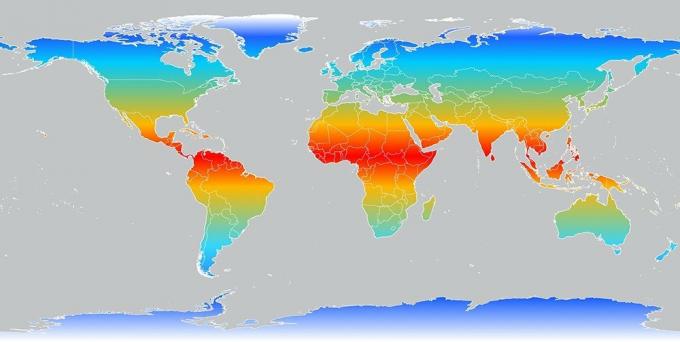
Climate map

This map shows how the climate is distributed across the planet. It can be seen that around the Equator are tropical and warmer areas. The closer the region is to the poles, the colder it will be.
Historical map

This type of world map that represents the geography of the world in other times. Depending on the period in which the map was constructed, some countries may not yet exist or the territorial limits may be different.
For example, ancient European maps from the Great Navigations (15th century) depicted monsters in the oceans. Navigators believed in aquatic beasts, which sank ships, and located them on maps. Today, it is known that these animals do not exist, therefore, maps no longer show them.
Meet others types of maps.
Meanings: more than a simple encyclopedia. A simple encyclopedia.


