The Territory of Zambia, located in the south-central portion of the African continent, has no outlet to the ocean and is limited to the Republic Democratic Republic of Congo (to the north), Angola (to the west), Namibia (to the southwest), Zimbabwe (to the south and southwest), Tanzania (to the northeast), Mozambique and Malawi (to the east). Most of its area is covered by savannas and the country is also home to extensive rivers, such as the Luangwa, Kafue and Zambezi, where the famous Victoria Falls are located.
A former British colony, Zambia (formerly Northern Rhodesia) gained independence on 24 October 1964. Since then, the country has joined the British Commonwealth – a bloc formed by the United Kingdom and its former colonies.
Zambia has one of the poorest economies on the planet, with copper extracting and exporting its main source of income. Another important ore for the country is cobalt. Agriculture, especially subsistence, employs around 70% of Zambians, who grow potatoes, corn, cassava, peanuts, coffee, cotton, sugar cane and tobacco. The industry, not very diversified, operates in the mineral treatment, cement and food production segments. Tourism also contributes to the National Gross Domestic Product (GDP). This sector is driven by national parks and waterfalls.
The population, made up of around 70 different ethnic groups, suffers from various socioeconomic problems. Most inhabitants live below the poverty line, that is, on less than $1.25 a day; the illiteracy rate is 30%; malnutrition affects 45% of Zambians; life expectancy is one of the lowest in the world (41.2 years); 14% have the HIV virus and the infant mortality rate is 90 for every thousand live births.
Do not stop now... There's more after the advertising ;)

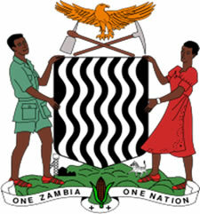
Zambia Coat of Arms
Zambia Data:
Territorial extension: 752,614 km².
Location: Africa.
Capital: Lusaka.
Tropical weather.
Government: Presidential Republic.
Administrative division: 9 provinces.
Language: English (official), regional languages (main: nianja, bemba and tonga).
Religions: Christianity 83.7% (Catholic 29.4%, Protestant 32.1%, Independent 15%, Other 7.2%), Traditional beliefs 12.8%, Other 3.1%, no religion and atheism 0, 4%.
Population: 12,935,368 inhabitants. (Men: 6,452,696; Women: 6,482,672).
Composition: Bembas 36.2%, nianjas 17.6%, tsongas 15.1%, rotses 8.2%, mambuês 4.6%, tumbucas 4.6%, others 13.7%.
Demographic density: 17.2 inhab/km².
Average annual population growth rate: 2.4%.
Population residing in urban areas: 35.51%.
Population residing in rural areas: 64.49%.
Undernourished population: 45%.
Life expectancy at birth: 41.2 years.
Households with access to drinking water: 58%.
Households with access to a health network: 52%.
Human Development Index (HDI): 0.395 (low).
Currency: Zambian Quacha.
Gross Domestic Product (GDP): $14.3 billion.
GDP per capita: $974.
External relations: World Bank, Commonwealth, IMF, WTO, UN, SADC, AU.
By Wagner de Cerqueira and Francisco
Graduated in Geography
Brazil School Team
countries - geography - Brazil School


