
Piauí is a Brazilian state that forms the Northeast region from the country, with a territory that is divided between the sub-regions of Meio Norte and Sertão. Its capital is the municipality of Teresina, also the most populous in the state. In total, Piauí has 3,281,480 inhabitants. Livestock is an important economic activity developed in the state.
Read too: What are the states of Brazil?
Piauí general data
Region: North East
capital: Teresina
Government: representative democracy
Areatterritorial: 251,755.485 km² (IBGE, 2020)
Population: 3,281,480 inhabitants (IBGE, 2020)
Densitydemographic: 12.4 inhab./km² (IBGE, 2010)
spindle: Brasília Standard Time (GMT -3 hours)
Climate: Tropical hot and humid type and semiarid
Geography of Piauí
Piauí is part of the Northeast region of the country. The state is limited:
to the northeast, with the Ceará
to the east, with Pernambuco
to the southeast and south, with the Bahia
to the southwest, in a narrow strip, with the Tocantins
to the west, with the Maranhão
To the north, Piauí has an exit to the OAtlantic ocean.
The territory of Piauí belongs to two of the four sub-regions into which the Northeast of Brazil is divided. They are the Sertão, which covers the east of Piauí, and the Meio Norte, which corresponds to the lands located to the west.
Piauí climate
In the eastern portion of Piauí, there is a predominance of climate semiarid. This type of climate is marked by high temperatures, which can reach 38 ºC, conditioned by low air humidity and irregular rainfall, which may cause long periods of drought. Rainfall rates range from 250 mm to 750 mm, with a drought that lasts from May to October, months in which several areas reach 0 mm of rain.
In the tropical climate of the hot and humid type, predominant in the west of the state, there are relatively milder temperatures, which can vary between a minimum of 18 ºC and a maximum of 35 ºC. Air humidity is higher, and annual rains reach 1200 mm.
Piauí relief
Piauí has a relief with modest altitudes, formed by a very old substrate and intensely shaped by the action of weathering agents. Predominate ways like plateaus and plains.
According to the classification proposed by Jurandyr Ross, the state is composed of three morphological units. The first is composed of the plains and by the coastal boards, which extend through the narrow coastal zone of the state. The second consists of the Planaltos and çslaps of Bacia do Parnaíba, which extend to the west of Piauí.
To the east, in turn, is the dSertaneja and São Francisco epression, where the highest altitudes in the state are located. Some of the plateaus located in this region have altitudes that exceed 800 meters, of which the Ibiapaba mountain range (or Grande mountain range) stands out.
Vegetation of Piauí
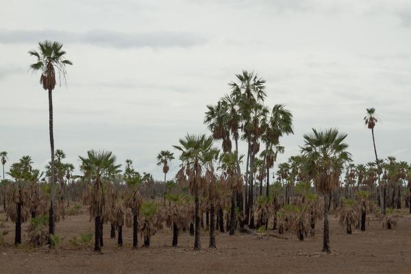
The vegetation cover of Piauí is composed of characteristic species from three domains, one of which is transitional. it is about the Cocais Forest, composed of palm trees and medium and large trees, such as carnaubas, babassu and buritis. This domain extends between the Amazon, the Cerrado and the Caatinga.
In portions of the west of Piauí and, above all, the south, the flora of the thick. In the eastern areas, the Caatinga. The coast of Piauí is covered by vegetation typical of humid areas, such as restinga and mangroves.
See too: What are the Brazilian biomes?
Piauí Hydrography
Most of Piauí is incorporated into the basin HParnaíba hydrographic. Some of the main rivers that flow through the state are: Parnaíba, Gurguéia, Poti, Canindé, Piauí, Guaribas and Uruçui Preto.
Piauí Map

Demographics of Piauí
The state of Piauí has a population of 3.281.480 population. It consists of one of the least populated states in the Northeast region, representing a share of 5.7% of the regional population and only 1.6% of the country. Your demographic density, when the 2010 Census was carried out, it was 12.4 inhabitants/km². Taking into account the updated values of population and area, we have a distribution of 13.03 inhab/km².
The population of Piauí is essentially urban, with 65.77% urbanization rate. The most populous municipality is the capital, Teresina, which has 868,075 residents. Next is Parnaíba, with 153,482 inhabitants. The smallest population in the state is the city of Miguel Leão, with 1246 inhabitants.
Population growth in the state happens slowly, having been one of the federative units that grew the least in the country in recent years. Between 2019 and 2020, at least 43 municipalities registered a drop in their population.|1|
See too: Age pyramids - graphic representations of the population structure of a given location
Geographical Division of Piauí
O IBGE started to divide the Brazilian states into intermediate geographic regions and immediate geographic regions. Piauí is composed of 19 immediate geographic regions, in which its 224 municipalities are distributed.. The immediate regions, in turn, are grouped into six intermediate regions. Are they:
Current–Bom Jesus, to the south;
Floriano, to the southwest;
Parnaíba, to the north;
Peaks to the east;
São Raimundo Nonato, to the southeast;
Teresina, which covers a strip in the north of the state, encompassing the capital.
Economy of Piauí
The Gross Domestic Product (GDP) of Piauí is R$50.37 billion, equivalent to 0.7% of the Brazilian GDP. Its about one of the smallest economies in the Northeast region, being also the 21st in the country. The services sector is the main one in terms of added value, with a share of 44.31%. Next comes industry, with 12.44%, and, finally, agriculture, with 9.93%.
The industry of Piauí is led by the civil construction sector, followed by public utility services. Other important branches of secondary activity are food and beverage production, clothing, and chemicals.
The agricultural sector has great economic strength in the state, with emphasis on the cattle herd and for agriculture, which is practiced in the Cerrado portions. These areas were targeted from the 1970s onwards, when there was a movement to expand the Brazilian agricultural frontier. A productive region known as Matopiba was formed in the North and Northeast regions, of which the producing municipalities in the south of Piauí are part. The agribusiness production model was adopted in these areas, based on the production of commodities such as soybeans, corn and cotton.
In addition to the aforementioned crops, Piauí is a producer of fruits such as cashew, mango and orange, and sugar cane.
Flag of Piauí

Government of Piauí
The government of Piauí is of the representative democratic type, with state elections held every four years so that the population can select its governors. At the head of the executive branch of the state is the governor. The Legislative is composed of three federal senators, 10 federal deputies and 30 state deputies.
Infrastructure of Piauí
The connection between the territory of Piauí and other states is made mainly through federal highways. One of them is the BR-230 or Transamazônica, which crosses the country from Paraíba to the Amazon. We can also mention the BR-020, which leaves from the Federal District, the BR-135, which runs from Maranhão to the Southeast, in Belo Horizonte, among others.
Some of the transport structures in Piauí are of great value to its production chains. The Transcerrados highway, which would be an important outlet for grain, currently presents a series of problems related to unpaved stretches. The railway sector has Transnordestina and the São Luís-Teresina railway. In the execution phase, the West-East Integration Railway (Fiol) will extend across the south of Piauí and will have a major impact on the economy of the Northeast. Added to this structure is the Parnaíba Export Processing Zone (ZPE).
It should be noted that Piauí is a great producer of wind energy, with potential to expand the total installed parks. Still, the main source of electricity generation in the state is the power of water.
Culture of Piauí
Piauí has a cultural wealth derived from indigenous, African, European and migrant peoples from other parts of Brazil. It expresses itself through religious and folkloric celebrations, dances, music, gastronomy and arts.
One of the typical celebrations is the National Meeting of Folguedos. Held annually, this festival brings together people and traditions from various states in the presentation of folk dances, square dances, concerts and also the boom my ox. In the city of Floriano, the famous reenactment of the Passion of Christ takes place. In music, the tradition ofsboth of çumbuca, from the quilombola community of Salinas.
The gastronomic diversity of the state includes cashew-based preparations such as cashew. Typical dishes include baião de Dois, capote, dried meat paçoca and Maria Isabel (rice with minced meat and a green smell).
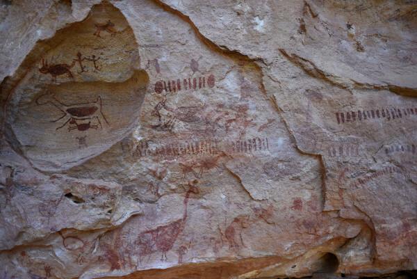
Piauí protects one of the places of greatest historical and cultural value for the American continent, the Serra da Capivara National Park, which is in the southeast of the state. Due to the thousands of archaeological sites found there, it is considered a World Heritage Site by Unesco.
History of Piauí
Piauí it was populated by several indigenous peoples before the first raids explorations that entered the south of its territory in the 17th century. One of the peculiarities of its history of formation in relation to other northeastern states begins to from then on, since the expeditions that would lead to the subsequent settlement of their lands took place by the interior.
The occupation happened as a result of the expansion of cattle raising, hence the importance of cattle ranching for the state. This process took place initially following the course of rivers such as the Gurguéia. Beyond the São Paulo scouts that arrived in the region in the second half of the 17th century, the presence of breeders from Bahia was also highlighted. These incursions resulted in the foundation of Oeiras, in 1695, which was established as the first capital of the state in 1759.
In 1718 the captaincy of São José do Piauí was created, which became a province in the 19th century, more precisely in 1821. In the year that Brazil was declared a republic, 1889, Piauí officially became a state. Its name is derived from Tupi-Guarani, and means “river of the piaus”.
Note
|1| In Piauí, 43 municipalities had a population reduction in 2020; see the list. Green City, 27 August 2020. Available in: https://cidadeverde.com/noticias/331121/no-piaui-43-municipios-tiveram-reducao-da-populacao-em-2020-veja-a-lista.
By Paloma Guitarrara
Geography teacher