A hydrography is an area of physical geography dedicated to the mapping and study of the water bodies of the planet Earth, including surface water (rivers, seas and lakes) and subsurface water (aquifers). This is a very important discipline for understanding the distribution and operation of systems water resources at different territorial scales, taking the hydrographic basins as the main unit of analysis.
Read too: Hydrosphere — the water layer of planet Earth
Topics of this article
- 1 - Summary on hydrography
- 2 - Video lesson on hydrography
- 3 - What is hydrography?
- 4 - Water cycle
-
5 - What is a hydrographic basin?
- → Major river basins in the world
- 6 - Hydrography of the world
-
7 - Hydrography of Brazil
- → Video lesson on hydrography in Brazil
- 8 - Importance of hydrography
- 9 - Solved exercises on hydrography
Abstract about hydrography
Hydrography is an area of Physical Geography dedicated to the study of water on planet Earth, performing the mapping and characterization of the different water reserves, as well as the way in which their distribution takes place and the its use.
The stages of the water cycle as well as their occurrence are part of hydrographic studies.
Watersheds are important units of analysis for hydrography. They are formed by a main river and its tributaries, with their own drainage regime for each of the corresponding areas.
The distribution of water throughout the world is unequal, both with regard to fresh and salt water reservoirs and its occurrence in each of the continents and countries.
Only 2.5% of the water contained in the hydrosphere is sweet. Of this fresh water, the largest portion is retained in glaciers and frozen surfaces.
The same happens in Brazil, a country that holds 12% of the world's fresh water. The largest portion of this resource is found in the North region, while the smallest volumes are concentrated in the Northeast region.
Brazilian hydrography is studied based on 12 hydrographic regions.
The Amazon basin is the largest hydrographic basin in Brazil and in the world. Its main river, the Amazon River, is the longest on the planet.
Video lesson on hydrography
What is hydrography?
The hydrography is an area of geographic knowledge dedicated to the study of water present on planet earth. As part of physical geography, hydrography is responsible for mapping and characterizing the different surface and subsurface water bodies, which are: rivers; lakes; seas; glaciers; oceans; aquifers.
The analyzes of this branch of geographic science also include the behavior of water in its most different physical states and the way it circulates through the environment and among living beings, which corresponds to the process we call the hydrological cycle or water cycle.
Another object of study in hydrography is the hydrographic basins, which, as we will see below, are important units for managing water resources in a given location.
water cycle
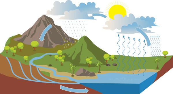
O water cycle it is a fundamental process for the maintenance of life on planet Earth. It is one of biogeochemical cycles that happen in nature, marked by the constant movement of water between the atmosphere and the terrestrial surface and subsurface, where it circulates between living beings and the physical environment (soil, rocks).
The hydrological cycle, as it is also called, is characterized by the change in the physical state of water, and its main source of energy is the heat emanated from the Sun. In short, understand the different stages of the water cycle:
Evapotranspiration: consists of the process of evaporation of surface water as a result of heating by energy from the Sun in conjunction with the transpiration process of plants and vegetables. Water in the gaseous state is then transferred to the atmosphere.
Condensation: when water vapor reaches higher layers and its temperature is reduced, it returns to the liquid state, which characterizes condensation. It is at this stage that cloud formation takes place.
Precipitation: consists of returning water to its liquid state (rains) or solid (snow or hail) to the Earth's surface, thus recharging waterways and returning to the oceans and seas.
Infiltration and runoff: both are processes that happen to water on the Earth's surface. In the first of these, infiltration, water enters the soil or rock, filling the empty spaces. Through infiltration, aquifers are recharged, which are underground water reserves. In the case of impermeable rocks or soils or those with low permeability, the phenomenon that occurs is that of surface runoff.
Do not stop now... There's more after the publicity ;)
What is a watershed?
Also called a drainage basin, Bhydrographic aciais an area drained by a main river, which gives the basin its name, and its tributaries and subtributaries. This area is delimited by the watershed, higher portions of the relief that separate them from other drainage units. All the water that enters this system through rainfall, mainly, is drained towards the same channel, which consists of the main river, whose bed is found in the lowest portion of the basin.
The main river of a watershed does not always flow into the ocean. When this happens, basins are classified as exorheics. Basins that flow into other water bodies in the interior of the continent, with no outlet to the ocean, are classified as endorheic. There are still the arreic basins, whose waters disappear, and the cryptorrheic, directed to underground reserves or caves.
The region delimited by the watershed is composed of its own ecosystems and also of cities that are supplied, in most cases, by the water bodies that make up the drainage basin. In this way, watersheds constitute important water management units in a region.
→ Major river basins in the world
Some river basins stand out for their dimensions and the socioeconomic importance of their rivers. Discover below the five largest river basins in the world.
Amazon Basin: located in South America, has an area of approximately 7 million km². It extends over six countries and a European overseas territory, the French Guiana, with its largest area included in the Brazil. The main river of the Amazon basin is the Amazon river, considered the longest and most voluminous in the world, with 6992 km in length.
Congo Basin: It has an approximate area of 4 million km², extending across the Central African region. The Congo Basin comprises a total of ten African countries such as Congo, Democratic Republic of Congo, Gabon It is Angola. Its main river is the Congo River, the second largest in the African continent, with a length of 4700 km.
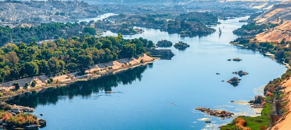
Nile Basin: also located on the African continent, it has 3400 km² and extends across the regions of North Africa and East Africa. It covers countries like Egypt, Chad, Ethiopia, Uganda It is Burundi, totaling 13 territories. The main river in this basin is the Nile, the second longest in the world, with a length of 6650 km.
Mississippi Basin: located in North America, is the largest watershed in the U.S. Its area is approximately 3000 km² and its main river is the Mississippi River, the second longest to bathe the US territory, 3766 km long and running across the country, from north to south, from the state of Minnesota to Louisiana.
Platinum Basin: located in the southern portion of South America, it has an approximate area of 3000 km² and covers the Brazilian, Argentine, Bolivian, Uruguayan and Paraguayan territories. Its main river is the Paraná River, with 4500 km of extension. Other important South American rivers make up this basin, such as the Paraguay River and the Uruguay River.
Earth is made up of 1.4 billion km³ of water, which is equivalent to 70% of the surface of our planet. This total volume of water has not changed since its formation billions of years ago.
Although it is a very large volume of water, not all of it is available for human consumption. This happens because the distribution of water across the different reservoirs is uneven, and only 2.5% of this amount corresponds to fresh water, and the remaining 97.5% is formed by salt water reservoirs.
Considering freshwater reservoirs, glaciers store 68% of the entire volume available in the world. Approximately 30% remain in the subsurface, such as aquifers, and only 0.3% of the fresh water present on planet Earth is stored in surface reservoirs such as rivers, lakes and swamps.
An important aspect of world hydrography that deserves to be highlighted is the fact that the potable water it is not evenly distributed across continents and countries. The Americas concentrate the largest share of the world's drinking water, which corresponds to 45% of the total, while Africa has the smallest share of all fresh water on the planet, at just 9%.
It is also noteworthy that the developed countries almost 60% of their water for industrial use, while in underdeveloped countries it is us countries emerging it is the agricultural sector that uses the largest share of this resource: approximately 80%.|1|
See too: Countries with the least amount of drinking water
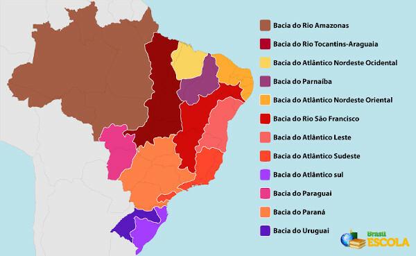
Brazil is home to 12% of all available drinking water in the world and just over half of South America's reserves, according to data from MapBiomas. As in the world, water is unevenly distributed across the territory Brazil, with greater concentration in the states of North region of the country and smaller volume in the states that make up the region North East.
Characterized by the predominance of rivers to the detriment of lakes and other surface reservoirs, Brazilian hydrography can be analyzed and understood based on the 12 different hydrographic regions into which the national territory is divided and which are listed below.
Amazon basin;
Tocantins-Araguaia basin;
São Francisco basin;
Parnaíba basin;
Paraná basin;
Uruguay basin;
Paraguay basin;
West Northeast Atlantic basin;
East Northeast Atlantic basin;
East Atlantic basin;
Southeast Atlantic basin;
South Atlantic basin.
→ Video lesson on hydrography in Brazil
Importance of hydrography
Hydrography is an important area of knowledge to have the full knowledge of the occurrence and distribution of water in a given territory, as well as the way these different water bodies behave and interact with each other. With this, it is possible to elaborate multi and interdisciplinary studies that will be important for several other sciences and, also, for the execution of engineering projects and infrastructure.
Hydrography is equally important for the elaboration of policies and strategies for the management of river basins and water resources in a municipality, region, state and even in a country.
Solved exercises on hydrography
question 1
(UEA) Watersheds are portions delimited by watersheds, which shelter a main river and its tributaries. About the Brazilian hydrographic basins, it is correct to say that
A) the São Francisco Basin has a perennial equatorial regime, high ground and many rivers contaminated by mercury.
B) the Amazon Basin features predominantly flat relief, meandering rivers and high rainfall.
C) the Platina Basin presents low precipitation, intermittent fluvial regime in the upper and medium courses and equatorial near the mouth.
D) the Tocantins Basin has high rainfall, low vegetation density and semi-arid climate on its right bank.
E) the Parnaíba Basin has rugged plateaus, good hydroelectric use and interconnection to other basins.
Resolution:
Alternative B
The main river of the Amazon basin, the Amazon River, although its source is located in the wAndes mountain range, traverses predominantly flat terrain, which favors the formation of meanders. This characteristic extends to the other watercourses of the basin. Also noteworthy is the frequent occurrence of rain, given its location in an area of equatorial climate.
question 2
(And either)
The ancient philosophers, observing the large volume of water in rivers such as the Nile, Rhine and others, imagined that the rains were insufficient to feed such considerable bodies of water. It was in the 18th century that Pierre Pernault measured the amount of rain for three years at the headwaters of the Seine. He also measured the volume of water in the said river and came to the conclusion that only a sixth part drained away and the remainder was evaporated.
LEINZ, v. general geology. São Paulo: Editora Nacional, 1989 (adapted).
The research done by Pierre Pernault directly contributed to the scientific explanation of
A) chemical weathering.
B) drainage network.
C) altitude thaw.
D) rain erosion.
E) hydrological cycle.
Resolution:
Alternative E
Pierre Pernault's research contributed to understanding the functioning of the hydrological cycle, or water cycle, which seeks to systematize the process circulation of this resource in the environment and in the atmosphere, including its different stages, such as evaporation, river recharge and runoff superficial.
Note
|1| HIRATA, Ricardo; VIVIANI-LIMA, Juliana Baitz; HIRATA, Harold. Water as a resource. TEIXEIRA, Wilson.; FAIRCHILD, Thomas Rich.; TOLEDO, Maria Cristina Motta de; TAIOLI, Fabio. (org.) deciphering the earth. São Paulo, SP: Companhia Editora Nacional, 2009. 2nd ed. P. 448-485.
By Paloma Guitarrara
Geography Teacher
Would you like to reference this text in a school or academic work? Look:
GUITARRA, Paloma. "Hydrography"; Brazil School. Available in: https://brasilescola.uol.com.br/geografia/hidrografia.htm. Accessed on July 2, 2023.