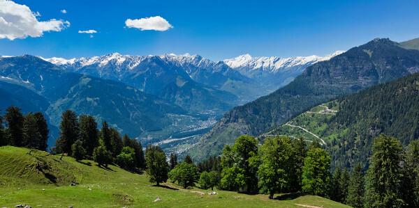
A Himalayan mountain range It is a mountain range located in the Asia, between the Tibetan Plateau and the plains of the Indian subcontinent. It stretches over 2500 km and passes through five countries:
Nepal;
Bhutan;
India;
China;
Pakistan.
The Himalayan Mountains act as an orogenetic barrier, impacting the winds It is rains in the region. Its glaciers originate and feed important Asian rivers. The Himalayas some of the highest mountains in the world, among them the myesterday everest, whose culmination is at an altitude of 8849 meters.
In recent decades, there has been a significant growth in tourism in the Himalayas, making this the main economic activity of many cities and towns located in the Himalayas. mountains or in its surroundings. Despite the benefits for the local economy, the tourism has negatively contributed to environmental problems in the Himalayas in conjunction with the growth of inhabited areas, highlighting impacts such as pollution, deforestation and loss of biodiversity.
Read too: Andes Mountains — the longest mountain range in the world
Topics of this article
- 1 - Summary about the Himalayan mountain range
-
2 - Characteristics of the Himalayan range
- Himalayan mountain range climate
- Himalayan mountain range vegetation
- Himalayan mountain range hydrography
- 3 - Mount Everest
- 4 - Location of the Himalayan range
- 5 - Map of the Himalayas
- 6 - Formation of the Himalayan range
- 7 - Tourism in the Himalayas
- 8 - Environmental impacts in the Himalayas
- 9 - Curiosities about the Himalayas
Summary about the Himalayan mountain range
The Himalayan range is a mountain range located in the Asian continent.
It passes through five countries: Nepal, Bhutan, China, India and Pakistan.
Its highest mountain is Mount Everest, its summit is 8849 meters high. altitude.
It presents climates very variable, between temperate and polar, with areas of eternal snow.
It also performs the function of orographic barrier.
Its vegetation consists of tropical forests in the foothills, temperate and mixed forests, and alpine vegetation.
It represents a watershed in Asia. It features several valleys and a dense drainage system, in addition to glaciers that originate important rivers in the region.
It was formed from the collision between the tectonic plates Indian and Eurasian.
Tourism is an important economic activity for the cities and towns formed in its mountains and in its region.
Many environmental problems affect it today, such as pollution caused by improper waste disposal, the logging and the loss of biodiversity.
Do not stop now... There's more after the publicity ;)
Features of the Himalayas
The Himalayan range is a chain or set of mountains (mountain range definition) located in the Asian continent. It stretches for 2500 kilometers, from east to west, thus being the sixth highest mountain range in the world, and varies from 200 to 400 kilometers, from north to south, totaling an area of approximately 595,000 km².
The Himalayas, as the mountain range is also called, separate the Tibetan plateau, to the north from the flood plains, from the Indian subcontinent, to the south, and thebrawl some of the highest peaks around the world. There are at least 110 mountains with an altitude greater than 7 thousand meters, which can reach 8849 meters in altitude, as is the case of Mount Everest, which we will study further ahead.
Himalayan mountain range climate
The Himalayan mountain range presents a great climatic variability. It is, moreover, a climatic factor that directly interferes with the behavior of the elements that define the different climates of the areas where it extends, especially in the Tibetan plateau. The Himalayan mountains play, in this sense, the role of an orographic barrier.
In general, in areas of higher elevation, temperatures are lower and the temperature range it's smaller. Also as a result of the altitude, many areas have what is called eternal snow, that is, they are constantly covered by a layer of ice. To the temperatures in the Himalayan range can vary between 11°C and -30°C.
To the areas located south of the Himalayas experience high volumes of rainfall, resulting from the summer monsoons and the obstacle formed by the mountain range to the hot and humid winds that blow from the ocean towards the Indian subcontinent. These are called orographic (or relief) rainfall. Precipitation can reach 3000 mm in some regions.
The opposite side, on the other hand, is characterized as a rain shadow region. Due to the presence of the mountains, the humid winds are retained in the southern portion, and the Tibetan plateau registers very low rainfall rates, varying between 75-150 mm per year.
Himalayan mountain range vegetation
Like weather events, the vegetation present in the Himalayan range varies according to the characteristics of the region, such as water availability, incidence of sunlight, altitude and soil type. The soils, it should be noted, are more fertile in the valleys, with the exception of the Indus valley, and in the eastern part of the mountain range.
In the lower lands, close to the foot of the mountain range, the presence of forests dense tropical type, but they cover a small area compared to other formations. At measure in As the altitude rises, the landscape changes, moving on to mountain forests, temperate mixed forests and alpine vegetation, to areas where no plant species is found.
The alpine vegetation, composed essentially of herbaceous plants and shrubs, starts at 3000 meters and extends to approximately 4500 meters in altitude, a milestone that varies according to the region observed.
The Himalayan mountain range is a important watershed of the Asian continent.In it are born some of the rivers main areas that bathe territories both north and south of the mountains, in addition to presenting glaciers that feed these waterways.
Among the main rivers of the Himalayan range are the Indus River and the Brahmaputra River, one of the main tributaries of the Himalayas. rio Ganges. This, in turn, originates from the Bhagirathi River, whose source is located in the Himalayas.
Read too: Iguazu Falls — set of 275 waterfalls located between Brazil and Argentina
Mount Everest
Mount Everest is the highest mountain in the Himalayan range and dthe world. It is located on the border between Nepal and the autonomous region of Tibet, belonging to the Mahalangur Himal subrange. The peak of Mount Everest is at an altitude of 8849 meters above sea level. It is cold all year round on Everest, where thermometers show between 0 and -30 ºC, and therefore there is a permanent layer of snow in the mountain.
Countless expeditions are made towards Everest every year, many of them with climbers who want to achieve the feat of reaching the top of the mountain. However, they are often faced with adverse weather conditions and natural phenomena, such as the avalanches (slides of snow and debris), which impede their progress and, in some cases, result in serious accidents. The first expeditions to Everest took place in the 1920s, and the first time the mountain peak was reached dates back to 1953, a feat achieved by a Nepalese and a New Zealander.

Location of the Himalayas
The Himalayan mountain range is located in Asia, separating the Tibetan Plateau to the north from the Indo-Gangetic Plain to the south. It is bordered to the northwest by the Hindu Kush and Karakoram ranges and to the east by the Nanga Mountains. Parbat and Namcha Barva, both part of the Himalayas and located respectively in the regions of Kashmir and Tibet.
The mountains that form the Himalayas are part of the territory of five countries:
Bhutan;
Nepal;
India;
China;
Pakistan.
Himalayan mountain range map

Formation of the Himalayas
The Himalayan mountain range it is a modern folding, type of geological structure of recent formation and which concentrates the highest altitudes on planet Earth. Another famous example of modern folding is the Andes mountain range in South America. These structures are formed through the orogenetic movements that occur in the Earth's crust, and for this reason they are also called orogenetic chains.
In the case of the Himalayas, the movement of tectonic plates that gave rise to this mountain range began 200 million years ago with the breakup of the supercontinent Pangea. From then on, the Indian plate, on which the Indian subcontinent is located, began to move towards the Eurasian plate, and the collision happened approximately 50 million years ago, closing the Tethys ocean, which bathed the region.
The continuous movement of collision of plates, which continues until the present, originated the mountains that make up the Himalayan range. It is interesting to note that the Indian plate is heading northwest, and moving at a speed of 5 cm/year. Due to this, the Himalayas become a few millimeters higher every year.
Read too: Earthquakes — phenomena resulting from the movement of tectonic plates
tourism in the himalayas
Tourism is an economic activity of great importance for communities living in the Himalayas. It is estimated that the mountain range annually receives 700 thousand tourists. Of those who seek out India as a tourist destination, at least a quarter venture towards the Himalayan mountains. It should also be noted that 10% of revenue in Kathmandu, the capital of Nepal, located in the Himalayas, comes from tourism.
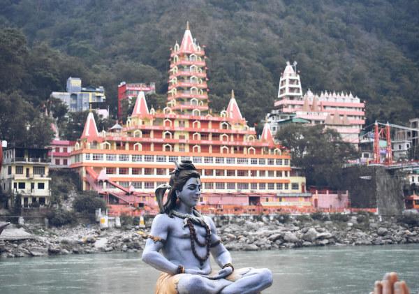
O mMount Everest is one of the main places to visit of the Himalayas, but tourism in the region is not limited to it. Many cities and small towns, some of them previously isolated, open up to the reception of tourists interested in knowing the natural landscapes, the daily life and the culture of the population living on the slopes or at the foot of the Himalayan range. In the Indian states of Himachal Pradesh, Sikkim and Uttarakhand, there are some of these locations, such as Spiti Valley, between India and Tibet, the Yumtang Valley and Rishikesh, considered the world capital of yoga.
Environmental impacts in the Himalayas
The advance of human occupation in the Himalayan mountain range region and the significant increase in tourist activity in the mountains have caused a series of environmental impacts, which are aggravated by the climate changes and the recurrence of previously infrequent natural phenomena. Among the main impacts and environmental problems observed in the Himalayas are:
Removal of vegetation cover and intensification of landslides.
Increase of air pollution due to the greater number of vehicles circulating.
Pollution of soils and watercourses due to irregular waste disposal.
Loss of biodiversity and increase in the number of endangered species extinction.
Melting of glaciers and formation of lakes in places where they did not exist before, in addition to the more frequent occurrence of floods.
Facts about the Himalayas
Approximately 53 million people live in the Himalayas.
The Himalayan Mountains are home to the third largest deposit of snow and ice in the world, after the Arctic and the Antarctica.
The most intense earthquake that happened in the Himalayas was recorded on August 15, 1950, and scored 8.7 on richter scale. It mainly affects northern India.
India, Nepal and Bhutan maintain control over the Himalayas, given that most of this mountain range extends through these territories.
The eastern portion of the Himalayas has a rich biodiversity which includes 163 animal species threatened with extinction, according to the NGO WWF, such as the Asian elephant, the Indian rhinoceros and the wild water buffalo.
More than 10,000 plant species are found in the eastern portion of the Himalayan range, according to WWF.
By Paloma Guitarrara
Geography Teacher
After all, what is an avalanche? Click here, understand how avalanches form and find out which were the worst avalanches in history.
Access our text and learn all about Bhutan, an Asian country located in the Himalayas. Know its main geographical aspects, population, history and culture.
Understand the formation of modern folds and the main characteristics of this type of geological structure.
Do you know the difference between epirogenesis and orogenesis? Click here and understand how these processes work in relief modeling and what their effects are.
Do you know where Mount Everest is? Discover this and other information here. Understand how Mount Everest formed and learn about the importance of this mountain.
Click here and discover the main geographical aspects of Nepal. Discover its history, culture and economy.
Do you know India? Click here and learn about the main geographical aspects of this country.