
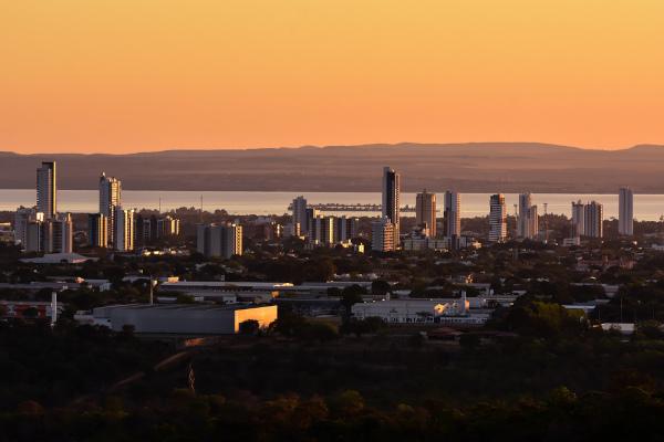
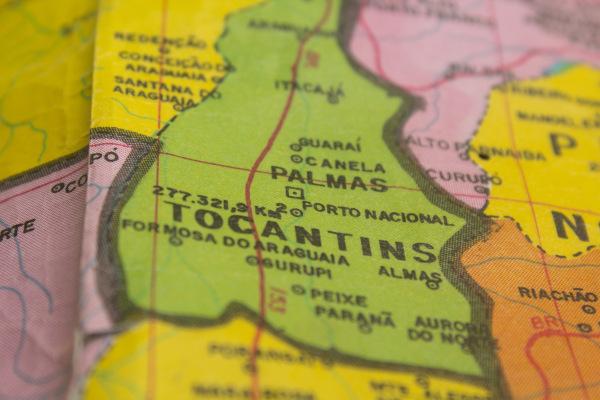
Palmas is a Brazilian municipality and capital of the state of Tocantins, in the North Region of Brazil. Bathed by one of the main rivers in the state, the Rio Tocantins, the city is the youngest Brazilian capital, having been founded in 1989. It has a semi-humid tropical climate and relief that ranges from flat to wavy. It is currently the largest city in Tocantins, with 306,296 inhabitants, and its main economy.
Read too: What are the capitals of Brazilian states?
Palms Summary
Palmas is the capital of the state of Tocantins, a state in the North Region.
It is the youngest among Brazilian capitals, having been founded in 1989.
The city is bathed by the Tocantins River, one of the most important in the state.
Its climate is semi-humid tropical, and the relief varies from flat to gently undulating, with the highest elevations located to the east.
It integrates the Cerrado biome.
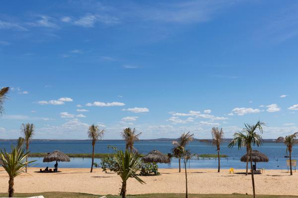
The damming of the waters of the Tocantins River gave rise to Ilha da Canela and river beaches that are tourist attractions in the capital.
With 306,296 inhabitants, it is the most populous municipality in Tocantins.
Its GDP is R$9.42 billion, representing the highest value in the state. The tertiary sector is the segment that generates the most revenue for the municipality of Palmas.
Palmas general data
Gentile: palmense.
-
Location of Palmas
Parents: Brazil.
Federative unit: Tocantins.
Intermediate region[1]: Palms.
Immediate region[1]: Palms.
Metropolitan region: Metropolitan Region of Palmas. Formed by the following municipalities: Palmas, Aparecida do Rio Negro, Barrolândia, Brejinho de Nazaré, Fátima, Ipueiras, Lajeado, Iracema do Tocantins, Miranorte, Monte do Carvalho, Oliveira de Fátima, Paraíso do Tocantins, Porto Nacional, Pugmil, Silvanópolis, Tocantinia.
Bordering municipalities: Aparecida do Rio Negro, Lajeado, Miracema do Tocantins, Porto Nacional, Monte do Carmo, Novo Mistura, Santa Tereza do Tocantins.
-
geography of palms
Total area: 2,227.329 km² (IBGE, 2020).
Total population: 306,296 inhabitants (IBGE, 2020).
Density: 102.90 inhab./km² (IBGE, 2010).
Climate: tropical semi-humid.
Altitude: 260 meters.
Time zone: GMT -3 hours.
-
Historic
Foundation: May 20, 1989.
geography of palms
Palmas is a Brazilian municipality and capital of the state of Tocantins, which belongs to the Rnorthern region from the country. The city is located in the central portion of Tocantins territory, covering an area of approximately 2,227 km². It borders seven other cities, which are:
Lajeado and Aparecida do Rio Negro, to the north;
Novo Concorde and Santa Tereza do Tocantins, to the east;
Monte do Carmo, to the southeast and south;
Porto Nacional, to the south and west;
Miracema do Tocantins, northwest.
The city of Palmas is the main city in the Metropolitan Region of Palmas, comprising the capital of Tocantins and 15 other municipalities in the state. Next, we will learn about the main physical characteristics of the capital of Tocantins.
climate of palms
The prevailing climate in the city of Palmas is the tropical semi-moist. The main feature of this weather type it is the presence of two seasons: one of them is hot and rainy, and the other is mild and dry. Precipitation is concentrated in the months from October to April, totaling 1,600 to 2,000 mm per year on average, with July being one of the driest months. Temperatures range from 30°C or more in the summer up to 16 ºC in the Winter, with averages around 25 ºC.
Relief of Palms
Situated in a plateau domain, the west of Palmas is characterized by lowered features, notably plains, due to the presence of the Tocantins River. Most of the land on which the municipality is located is flat or gently undulating, while to the east it is possible observe higher altitude and more rugged features, such as the Serra de Lajeado, a few kilometers from the capital.
Palm Vegetation
The vegetation cover of palms integrates the biome thick, being composed of forest and rural formations. Near the water courses, the presence of riparian forest can be observed. It is estimated that almost 30% of the Cerrado remains preserved in the region, which includes fauna and flora |1|. Still, the burned (natural or anthropogenic) and urban expansion itself are threats to this biome.
Read too: Fires in the Pantanal — phenomena that can be natural or anthropic
Palmas Hydrography
The Tocantins River is the main watercourse that bathes the city of Palmas. The so-called Lago de Palmas is formed by the waters of Tocantins through the damming of water for the construction of the Power Plant of Lajeado, thus giving rise to Ilha do Canela and several river beaches, which have become tourist attractions in the municipality.
Map of Palmas
demography of palms
The city of Palmas has 306,296 inhabitants, according to the estimates of the IBGE for the year 2020. It is thus the most populous municipality in the state of Tocantins, home to 19.2% of all Tocantins. It is still about the smallest capital in the North Region and in Brazil, ranking 92nd in the list of the most populous municipalities in the national territory.
THE demographic density Palmas is 102.90 inhab./km², much higher than that of the state of Tocantins, which is 4.98 inhab./km². a portion of 97.1% of Palmas residents live in the urban area of the municipality, while the rural area comprises 2.87% of its residents, as indicated by the last IBGE census, carried out in 2010.
More than half of the population of Palmas self-declares as brown, reaching a share of 55.41%. Whites are the second group with the highest number of people, corresponding to 32.39% of the city's residents. Blacks add up to 9.35%, yellows account for 2.63% and indigenous people make up only 0.22% of the population of the capital of Tocantins.
Check out our podcast: What do I need to know about demographic theories?
Geographical division of Palmas
The current Master Plan of the municipality of Palmas indicates forms of territorial division that serve different planning purposes, such as through zones and macrozones and also through districts.. These are currently three in number:
Palmas, the largest of them, covering the west and part of the north;
Buritirana, which also integrates part of the north and west; and
Taquaruçu, in the south-central portion of Palmas.
Economy of Palms
The largest municipal economy in Tocantins is that of its capitall, Palms. The city has a Bruno Internal Product (GDP) of R$9.42 billion or 26.4% of the state's GDP. Considering the entire set of municipalities in the country, Palmas is in 116th place, in addition to being the 7th largest economy in the Northern Region of Brazil.
The main sector of the economy, that is, the one that presents the greatest participation in the value added to the municipal GDP, is the tertiary sector. This is characterized by trade activities and also by the most varied types of services provided. Disregarding public services, in Palmas this sector accounts for 60.28% of GDP.
With four industrial districts, one of them in the implementation phase, we have to the industry corresponds to a share of 14.11% of the GDP of Palmas. In these areas dedicated exclusively to business activity, there is the presence of various branches of production, such as food and beverages, civil construction, metallurgy and steel, plastic materials, plaster manufacturing, marble and vehicles.
Agricultural activity, of great importance to Tocantins, accounts for 0.63% of the capital's GDP. Soybean production and cattle raising stand out.
Government of Palmas
Palmas has a representative democratic government. The governors of the municipality are chosen by the population through municipal elections, which are held every four years. O Mayor is the head of the executive branch and the main position in the municipal hierarchy. The Legislative, in turn, is represented by the City Council, composed of 19 councilors.
The city is the capital of the state of Tocantins, which means that it represents its political-administrative center. The seat of the state government, therefore located in Palmas, is located at Palácio Araguaia.
Infrastructure of Palmas
With the largest portion of their households installed in the city's urban area, around 31.3% of homes in Palmas were located in areas with urbanized roads, that is, paved and equipped with sidewalks and manholes, as shown by IBGE (2010). Adequate sanitary sewage was a reality for 67.6% of households, while the water supply network in the Palmas municipality and access to electricity covered, respectively, 95.5% and 95.3% of households in the capital Tocantins.
In addition to being the main economic and political center of Tocantins, Palmas is located in a region of intense economic and commercial dynamism, driven by agricultural activities and agribusiness, belonging to the productive region known as MATOPIBA (Maranhão, Tocantins, Piauí and Bahia). In this way, the highways crossing the city are used both for transporting people and cargo, such as agricultural commodities.
Another important modal for this type of service is the rail, highlighting the stretch of the North-South Railway between Palmas and Anápolis (GO). The Tocantins River is also used as a means of transport. In addition, the city of Palmas is home to the Brigadeiro Lysias Rodrigues Airport, one of the main airports in Tocantins.
Read too: What is the relationship between infrastructure and development?
Culture of Palmas
The city of Palmas is quite young compared to other Brazilian capitals and has a wide variety of cultural establishments, where it is possible to enjoy and appreciate the cultural and natural richness of Tocantins. The capital is close to an important tourist region in the state, Jalapão, and the Roncadeira waterfall. The damming of the waters of the Tocantins River provided the formation of islands and landscapes such as that of Ilha da Canela itself, which we mentioned earlier, of Praia da Graciosa and Praia do Prata.
The main theater in the city is Theatro Fernanda Montenegro, also featuring the SESC theater, art gallery, libraries, arts square and other cultural spaces, such as the Casa da Cultura Prof. Maria dos Reis and the Casa Suçuapara Museum.
history of palms
Palmas is the youngest capital in Brazil, created in 1989, one year laterof creationdthe state of Tocantins. The city was founded on May 20, while its official installation took place on January 1, 1990, when the transfer of the then provisional capital, which was in the city of Miracema, northwest of Palms.
The construction of the city took place under the government of Siqueira Campos, and its main objective was to promote the development of that region. Its creation was not without obstacles, which ranged from normative, such as the need for a political-administrative structure, to political ones, but which were soon overcome. With the new city, many migrants were attracted, and the capital of Tocantins saw its population expand rapidly. In 1991, Palmas already had more than 24 thousand inhabitants |2|. Located in an area of high economic dynamism, the capital is today the largest city in Tocantins, with 306,000 residents, and its main political and economic center.
Grades
|1| KINGS, Patrick. At 32 years old, Palmas conserves native vegetation and brings people closer to wild animals. G1, 20 May 2021. Available on here. Accessed on July 23 2021.
|2| LIMA, Erica. História de Palmas rescues the struggle for the creation of the State of TO. Tocantinense News Agency, May 20 2013. Available on here. Accessed on July 23 2021.
By Paloma Guitarrara
geography teacher