
THE regionSoutheast it is known for its economic strength and its big cities. It is located in São Paulo, Rio de Janeiro and Belo Horizonte, some of the main Brazilian cities and very important for the national economy.
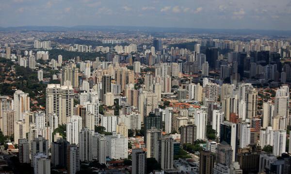
A striking fact in the Southeast is its population. The region is the most populous in Brazil, with more than 90% of the population living in urban areas, being also the most urbanized. Furthermore, its economic indices are high, as is the rate of industrialization. In the not too distant past, in the 20th century, it was the territory that most attracted migrants in search of better living conditions and work opportunities.
Read more: Regions of Brazil - groupings of states with similar characteristics
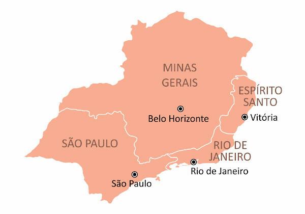
States of rSoutheast region
The states in the Southeast region have a diversified economy, with many opportunities in the third and fourth economic sectors. In total there are four states that make up this region. Look at them, in alphabetical order, with their respective capitals.
States |
capitals |
Gentiles |
Holy Spirit |
Victory |
Capixaba or Espírito Santo |
Minas Gerais |
Belo Horizonte |
miner |
Rio de Janeiro |
Rio de Janeiro |
Fluminense |
São Paulo |
São Paulo |
Paulista |
General data for the Southeast region
See now some statistical data from this region, according to the Brazilian Institute of Geography and Statistics, the IBGE. These data are from 2019.
Territorial area: approximately 925 thousand km², which represents 12% of the Brazilian territory.
Population: 88,371,433 inhabitants
household income per capita (in reais): 1666,75
Demographic density: 95.13 inhabitants per km²
Human development Index: 0,753
Elementary school enrollment: 10,384,771 students
Gross Domestic Product (in reais)|1|: 2.4 trillion
Infant mortality rate|1|: 12,6
Brief history of the Southeast region
One of the reasons for the beginning of the occupation of Southeastern Brazil was the gold discovery in the region, in the 17th century, around 1690, and of other precious stones, such as diamonds. Such ores were found, at first, in Minas Gerais, which gave rise to several villages that later became large cities.
The population needs of those living in the mine region led to the emergence of agricultural and commercial activities. Interest in gemstones was so great that it attracted countless migrants in the 18th century. Due to these factors, and a few more, such as the decline in the Northeast, the Portuguese government decided, in 1763, to transfer the capital from Salvador to Rio de Janeiro. With that, the center of the colonial economy became the Southeast.
Throughout the 19th century, other economic activities emerged in the region, such as the coffee growing. Initially, this crop was introduced in the state of Rio de Janeiro, in the beginning of the 19th century, in the region of the Paraíba do Sul river. Over the years, production expanded to other states in the Southeast, mainly in São Paulo.
At that time, most production was turned to the foreign market, with African slave labor. Due to the rugged terrain, Rio de Janeiro soon saw production moved to São Paulo, on relatively flat terrain.
Deforestation on the slopes of Rio de Janeiro and the accentuated erosion process contributed to the coffee gain strength in the flat lands of São Paulo. Thus, the state of São Paulo began to dominate coffee production in Brazil in the second half of the 19th century.
With the abolition of slavery, in 1888, and the strong immigration from northeastern and european, the Southeast developed a high population contingent and vast workforce, in addition to capital from coffee for the development of industrial activities. These facts led to the beginning of Brazilian industrialization in the region, at the end of the 19th century, which is currently the most industrialized in the country.
See too: How was the life of ex-slaves after the Golden Law?
Southeast region climate
O weather in ssoutheast is basically ttropical due to its geographic location. It is a region located between the tropics, with high temperatures in most states. However, some factors change its climate, such as altitude, maritime (influence of air masses coming from the ocean) and latitude.
O relief (altitude) exerts a great influence on rainfall distribution and temperature differences. In the city of Rio de Janeiro and in Santos, there are higher rainfall rates than in Belo Horizonte, for example. This is because the first ones are coastal, receiving a lot of moisture from the ocean (maritime). The capital of Minas Gerais is located in an elevated area of 852 m above sea level, with neighborhoods that reach more than 1500 m in altitude.
In general, higher cities have lower temperatures. In Serra da Mantiqueira, temperatures are low on the border between Minas Gerais and São Paulo. The highlight of this area is the city of Campos do Jordão (SP), which attracts numerous tourists due to its cold climate and high altitude (more than 1600 m above sea level). In these regions, the climate is the ttypical of Theattitude, with low temperatures, presence of frost in the Winter and 1500 mm annual rainfall.

On the coast, we have the weather tropical coastal, with high temperatures and high rainfall.
Another climate present in the region is the ttropical semiarid, located in the north of Minas Gerais, in the region of Vale do Jequitinhonha. In this area, temperatures are quite high, and rainfall is scarce and poorly distributed throughout the year.
Southeast region relief
The Southeast region has the highest relief. We can highlight three relief units in this region: plateaus (most), depressions and plains.
You plateaus can be divided into three groups, according to the classification of Jurandyr Ross:
Plateaus and mountains of TheAtlantic thereThis one-ssoutheast: area that goes from the eastern part of Minas Gerais and Espírito Santo and reaches the eastern part of São Paulo. In this group, Serra do Mar and Serra da Mantiqueira stand out.
Plateaus and plateaus of Bacia do Paraná: located in the west of São Paulo and in part of the Minas triangle. Area of fertile soil, known as terra roxa, which made it possible to grow coffee in the high and flat plateaus.
Plateaus and mountains of Goiás-Minas: the highlight is the Serra da Canastra, located in the southwest of Minas.
At depressions are located in São Paulo, between the plateaus of the east-southeast and the plateaus of the Paraná basin. This area in the interior of São Paulo was also useful for growing coffee, as its erosive process is less accentuated.
already the plains they are located on the Southeast coast and also on some riverbanks (these smaller than the coastal ones). In some regions, the mountainous relief gives rise to cliffs that can be found on the southern coast of the state of Rio de Janeiro.
Southeast region hydrography
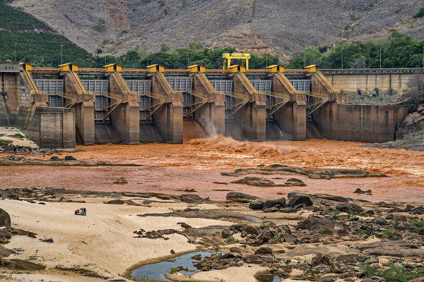
The rugged relief of the Southeast region provides a wide distribution of river water to other regions of the country. Because of this, there are two large hydrographic basins in the region — Paraná basin and São Francisco basin —, in addition to three hydrographic regions — South, Southeast and East Atlantic.
THE Paraná basin is present in the states of Minas Gerais and São Paulo, with important rivers that contribute to the water supply and the electric power generation for the population. As a highlight, we mention the Tietê, Grande and Paraná rivers. There are also hydroelectric plants in this basin, such as the Furnas plant, in Minas Gerais.
already the San Francisco basin it is fundamental for Minas Gerais, the only state present in it. The river San Francisco born in the Serra da Canastra and is essential for supplying the metropolitan region of the capital of Minas Gerais, Belo Horizonte. This river runs from south to north, having its mouth in the Northeast region.
THE hydrographic region TheAtlantic sul is present in the extreme southeast of São Paulo, having its greatest importance in the southern region of the country. already the region TheAtlantic ssoutheast it is present in the four states, with the following rivers as a highlight: Rio Doce, which originates in Minas Gerais, passes through Espírito Santo and flows into the Atlantic Ocean; Paraíba do Sul river, which runs through an important industrial area in São Paulo; and the Ribeira de Iguape river, which originates in Paraná and has its mouth in the state of São Paulo.
Also access: Disruption of the dam in Brumadinho
Southeast region vegetation
Of the five Brazilian regions, the Southeast is the one that but presents a difference in natural landscapes if we compare with native vegetation. High industrialization and urbanization had a contribution in this, having destroyed large areas of forests for the construction of cities, railways and industrial parks. Currently there are few remnants of green areas in the region.
In the Southeast we can find, basically, four types of vegetationAttractions: Caatinga, Cerrado, tropical forest (Atlantic Forest) and coastal vegetation (Mangroves).
THE Çhit is common in the north of Minas Gerais due to the semiarid climate. It is a landscape similar to that of the Northeast region, mainly in the Jequitinhonha valley region.
already the Çwrong, vegetation very common in tropical climates, is found in São Paulo and in much of Minas Gerais. It is a vegetation with tortuous branches, of low and medium size, but with deep roots, capable of fetching water underground in the dry season.
THE Mok THEtlantic it has a great biodiversity and can be found in the four states. Due to this biodiversity, was heavily deforested for commercial and urban planning purposes, leaving little original vegetation.
On the coast there are Mangels and Rslings, vegetation typical of this area. In the Southeast, however, real estate speculation affects this vegetation, which impairs the ecosystem and life present in these biomes.
Southeast region demographics
The Southeast region has almost 90 million people, according to IBGE data from 2019, being the most populous in the country, with the highest urbanization rate (93%). However, its population grew significantly only in the late nineteenth and last centuries. the strong European immigration (late 19th century) and Brazilians from other regions, such as those from the Northeast (mid-1940s-50s), contributed to this growth.
As it has the best economic and social indicators, migration was quite accentuated in this region. However, in recent decades, migrants have preferred other regions, such as the Midwest, to seek better conditions. That's because there is a big urban swelling, resulting in serious social problems, such as homelessness, unemployment and underemployment.
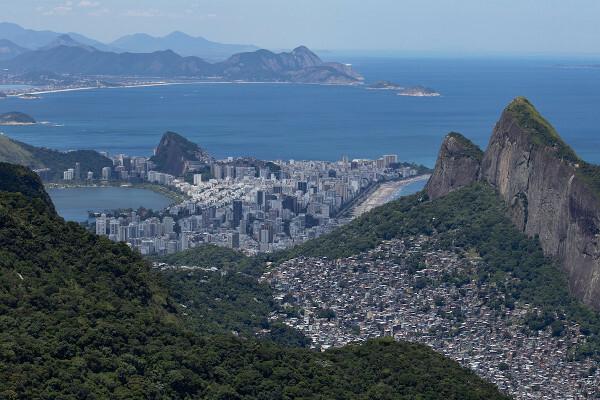
In the Southeast are located the two largest metropolitan regions in Brazil, São Paulo and Rio de Janeiro. Together, the two regions concentrate more than 30 million inhabitants, according to the Institute for Applied Economic Research (IPEA) in 2019. As a result, there is a large concentration of commercial, industrial and technological activities in these two areas of the Southeast.
Main economic activities in the Southeast region
THE economic strength from the Southeast is explained by history, from the times of gold extraction, through the cultivation coffee, and currently with the concentration of various industries, both national and transnational corporations.
Brazilian industrialization reached its peak in the 1950s, starting decades earlier in the Southeast region. This peak reached the Southeast in a positive way, as it was in this region that the best infrastructure conditions for the installation of factories and industrial clusters.
Currently, the territory has a large industrial park, mainly in São Paulo, in the region metropolitan area (ABC Paulista: Santo André, São Bernardo do Campo and São Caetano, industrial cities), and in Rio de January, withThe oil industry.
There is an ongoing strong industrial deconcentration of large metropolises due to several factors, such as expensive land, urban swelling and tax incentives on the part of smaller cities. As a result, some areas in the interior of the Southeast became industrial centers, such as Contagem, in Minas Gerais. In addition, the road network in the region contributes for industries to depart for the interior, but without losing the large consumer market existing in large cities.
The Southeast has important mineral resources, such as iron and manganese, found in Minas Gerais, in the whatquadrilateral ferroneous. These minerals are exported around the world via the Port of Tubarão, in Espírito Santo.
Petroleum and sea salt they are also present in the region's economy. Today, the state of Rio de Janeiro is the country's largest oil producer, followed by Espírito Santo, and the second largest in terms of salt.
The region is also strong in livestock. According to IBGE, with data from 2018, the Southeast comprises the third largest cattle herd in Brazil, with more than 37 million heads of cattle. The highlight in the region for this production is the state of Minas Gerais, with strength for the dairy industries. The swine herd is also present in the economy, which concentrates the second largest herd of this species in the country, with more than seven million pigs.
See too:What are the differences between export and import?
Cultural aspects of the Southeast region
with the strong migration occurred to the Southeast in past centuries, the cultural manifestations present in this region have indigenous, black and European influence, in addition to the Asian influence.
One of the most famous parties in the world takes place in the city of Rio de Janeiro and also in São Paulo: the Carnival. The carnival festivities in these two cities are famous for their large gatherings and parades of andschools of sboth, attracting people from all over Brazil and from various corners of the world. Also, in Rio de Janeiro, there is the famous rNew Year in Copacabana, a party that brings together two million people on the beachfront.

There are also, in Espírito Santo, the Byou walk from çongo, of indigenous origin. They are folk bands, with simple dances and rhythms, in which the congueiros sit on drums forming a circle. In addition to beating the drums, there are other musical instruments that enhance the dance, such as the coat, which looks like a reco-reco.
In Minas Gerais we have the çong, a kind of dance and music born from the fusion of African rites with the Catholic religion, with stories that pay homage to Our Lady of the Rosary.
Grades
|1| 2010 IBGE census data.
Image credit
[1] Joa Souza / Shutterstock
By Attila Matthias
Geography teacher
